|
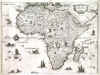
AFRICA (CONTINENT):90. Hondius, J. ‘NOVA AFRICAE TABULA. Auctore Jodoco Hondio’. Genuine antique map of the continent of Africa, over 400 years old. Large cartouche, sailing ships and sea monsters. Published in Amsterdam 1606 [30867] 38 x 50 cm. Full contemporary original
colour. Light even overall age toning. Excellent condition. £750
Based on Mercator, but with considerably altered coast line and changed Cape area, this antique map of the continent of Africa by Hondius is a stunning example of 17th-century cartography. The map is detailed and carefully crafted, featuring the entire continent of Africa, with its various regions and countries clearly delineated. The map is filled with intricate details, such as cities, rivers, mountains, and other geographical features. Norwich/Maps of Africa #27. |
 |
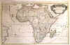
AFRICA (CONTINENT):91. Merian, Matthaeus. ‘NOVA DESCRIPTIO AFRICAE’. Map of the continent of Africa with small cartouche, sea monsters, sailing ships and compass rose. Numerous wild animals on the continent. Engraved by Merian and published by Johann Ludwig Gottfried in Frankfurt 1646 [20175] 27 x 36 cm. Left and right margins extended and neatlines redrawn, otherwise very good condition. £200
Uncoloured as originally published. |
 |
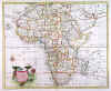
AFRICA (CONTINENT):92. Sanson, N. ‘L’AFRIQUE DIVISEE SUIVANT L’ESTENDUE DE SES PRINCIPLES PARTIES ......’. Large map of Africa, printed on two sheets and joined. Elaborate title cartouche. Published by Hubert Jaillot from the plate by Nicolas Sanson 1692 [22158] 54 x 87 cm. Decorative title cartouche and scale of miles uncoloured, the map in original outline colour. Excellent condition. £450
Norwich 4. |
 |
|
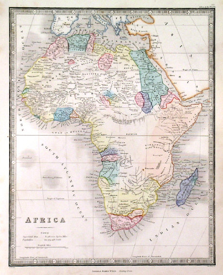
AFRICA (CONTINENT):93. Bowen, E. ‘A NEW AND ACCURATE MAP OF AFRICA...’. Antique map of Africa with pictorial cartouche. Emanuel Bowen ca. 1766 [26913] 34 x 42 cm. Recent outline colour. Excellent condition. £200
|
 |
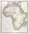
AFRICA (CONTINENT):94. Reinecke, J. C. M. ‘CHARTE VON AFRICA...’. Antique map of Africa. Johann Christoph Matthias Reinecke for Verlag des Geograph. Instituts Weimar 1812 [25842] 49 x 57 cm. Original outline colour. Excellent condition. £120
|
 |
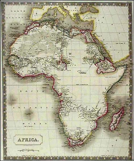
AFRICA (CONTINENT):95. Hall, S. ‘AFRICA’. Sidney Hall 1829 [19254] 51 x 41 cm. Original outline Colour. £150
|
 |
AFRICA (CONTINENT):96. Bell, A. ‘AFRICA’. Antique map of Africa. Allan Bell 1837 [18097] 33 x 29 cm. Full original colour. Excellent condition. £100
|
 |
AFRICA (CONTINENT):97. Wyld, J. ‘AFRICA’. Antique map of Africa. James Wyld ca. 1849 [26387] 27 x 23 cm. Full original colour. Excellent condition. £75
|
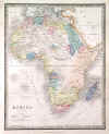 |
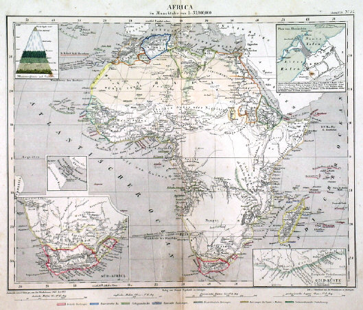
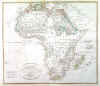
AFRICA (CONTINENT):99. Völter, D. ‘AFRICA’. Antique map of Africa with inset maps of South Africa, Gold Coast in Ghana, Port of Alexandria, and Bab al Mandab straights between Africa and Arabia. Small botanical diagram of the vegetation zones of Mount Teide on Tenerife. Daniel Völter for Weychart in Esslingen ca. 1855 [17371] 25 x 32 cm. Original outline colour. Excellent condition. £100
Uncommon. |
 |
|
|