AMERICA (CONTINENT):138. Ortelius, A. ĹAMERICAE SIVE NOVI
ORBIS, NOVA DESCRIPTIOĺ. Map of the Western Hemisphere with North and South America and the Pacific islands incl. ĹNova Guineaĺ and ĹTerra Australisĺ. Dated 1587, published in the Latin text edition of the Theatrum Orbis Terrarum by Abraham Ortelius 1592 [23730] 35áxá48ácm. Full original
colour. Excellent condition. £3250
van den Broecke 11. - Burden 64/state 1. |
 |
AMERICA (CONTINENT):142. Macquart, D. ĹLĺAMERIQUE SUIVANT LES DERNIERES OBSERVATIONS...ĺ. Antique map of North and South America. California is shown as an island. Denise Macquart for Buffier ca. 1714 [20574] 18áx 14ácm. Recent outline
colour. Excellent condition. £180
|
 |
AMERICA (CONTINENT):143. Bowen, E. ĹA NEW AND ACCURATE MAP OF AMERICA...ĺ. American hemisphere. West Coast above California largely undefined. Emanuel Bowen for Harris/Navigantium 1748 [19614] 35áxá45ácm. Figurative cartouche showing natives and alligator.
Uncoloured. Excellent condition. £350
|
 |
|
NORTH AMERICA:155. Bourgoin, P. ĹCARTE DE LĺAMERIQUE SEPTENTRIONALEĺ. Antique map of North America with cartouche and scale of miles. P. Bourgoin ca. 1766 [23555] 34áxá42ácm. Original outline
colour. Faint waterstaining to lower blank white corners, not affecting image, otherwise very good condition. £350
Uncommon. |
 |
|
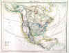
NORTH AMERICA:156. Cary, J. ĹA NEW MAP OF NORTH AMERICA...ĺ. Antique map of North America, West Indies and Central America. John Cary 1806 [26167] 46áxá51ácm. Full original
colour. Excellent condition. £350
|
 |
NORTH AMERICA:158. Hall, S. ĹNORTH AMERICAĺ. Sidney Hall 1829 [19256] 51áxá42ácm. Original outline
colour. Very good condition. £250
|
 |
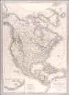
NORTH AMERICA:159. Lapie, P. ĹCARTE DE LĺAMÉRIQUE SEPTENTRIONALEĺ. North and Central America with a small inset map of the Aleutian islands. Texas is shown as an independent Republic. Pierre Lapie 1838 [16624] 54áxá39ácm. Original outline
colour. Excellent condition. £350
|
 |
NORTH AMERICA:160. Duvotenay, Th. ĹAMÉRIQUE SEPTENRIONALEĺ. Antique map of North America, showing Texas as an independent Republic. Engraved by Dyonnet after Benard for Thunot Duvotenay ca. 1840 [20765] 52 xá35ácm. Recent outline
colour. Excellent condition. £150
Few old marginal annotations in ink reaching into left neat line. |
 |
|
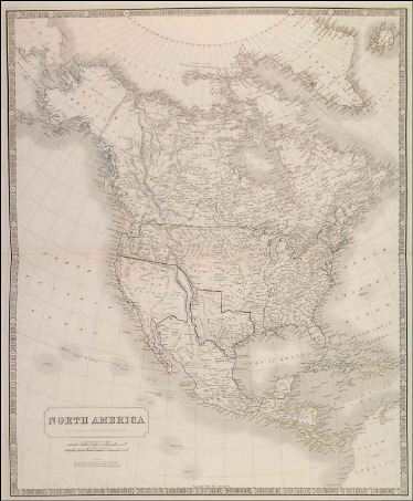
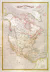
NORTH AMERICA:161. Johnston, A. K. ĹNORTH AMERICAĺ. Texas is shown as an independent Republic with the Pan-handle. There is a Ĺnoteĺ stating that the whole of the territory, to the west of the Rocky Mountains, between the Mexican and the Russian boundaries, is claimed by both Gt. Britain & the United States. A. K. Johnston 1843 [21081] 60áxá50ácm. Recent outline
colour. Excellent condition. £650
|
 |
NORTH AMERICA:164. Völter, D. ĹNORD AMERICAĺ. North America and West Indies. Texas is shown as an independent Republic in the shape of a heart. D. Völter for Dannheimer in Esslingen ca. 1845 [17263] 25áxá32ácm. Original outline
colour. Excellent condition. £120
Uncommon.
|  |
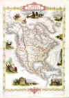
NORTH AMERICA:167. Tallis, J. 'NORTH AMERICA'. Antique map of North America with several vignettes showing wildlife, natives, settlers and scenery. John Tallis ca. 1851 [26467] 34áxá25ácm. All vignettes and border recent
colour. Excellent condition. £195
|
 |
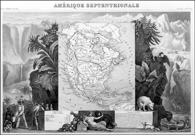
NORTH AMERICA:168. Levasseur, V. ĹAMERIQUE SEPTENTRIONALEĺ. Antique map of North America, showing Texas as a Republic. Very decorative pictorial scenic surround of natives, animals and allegorical figures. Laguillermie for Levasseurĺs Atlas Universel Illustré ca. 1852 [15628]
28 x 43 cms overall. The map in original outline colour. Excellent condition. £150
|
 |
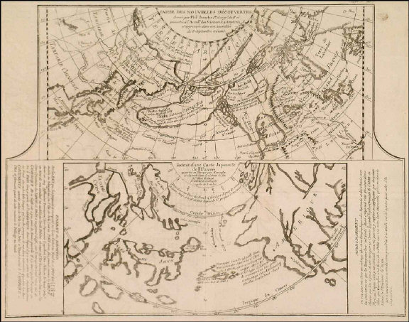
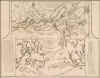
NORTH AMERICA and NORTH PACIFIC:170. De Vaugondy, R. ĹCARTE DES NOUVELLES DÉCOUVERTES DRESSÉE PAR PHIL. BUACHE ...ĺ and ĹEXTRAIT DĺUNE CARTE JAPONOISE DE LĺUNIVERS...ĺ. Two different maps on one sheet, one showing arctic North America with an oddly shaped Alaska, North Pacific, northeast Asia and a large Bay of the West (ĹMer de lĺOuestĺ) after a map by Philippe Buache of 1752, the other showing North Pacific, Japan, Korea and California after a map by
Kaempfer. Published in Diderotĺs Encyclopaedia ca. 1770 [17840] 29áxá37ácm.
Uncoloured. Excellent condition. £150
Pedley 452. |
 |