|
|
 |
|
 |
|
 |
|
 |
|
 |
|
 |
|
 |
|
 |
|
Phone: 01732 460025 /
international: +44 1732 460025
GV@garwood-voigt.com
Payment by credit card after receipt of our invoice or by bank transfer
(Pound Sterling or EURO). Within the same title all maps are listed chronologically. Measurements are given in centimetres, height by width, excluding margins.
We guarantee all items to be genuine, in good condition and returnable within
thirty (trade: eight) days for a full refund (excl. postage) if not satisfactory for whatever reason. For our full Terms and Conditions click the link on our Catalogues page.
Antique Maps and Prints of Austria, Salzburg, Vienna
Exchange rate (approximately): £ 1.00 = EUR 1.15 = US-$ 1.25
AUSTRIA: 846. Homann, J. B. ëARCHIDUCATUS AUSTRIAE SUPERIORIS...í. Antique map of Ober-Österreich between Inn, Donau and Enns, reaching from Passau along the Danube to Ybbs, and south to Salzburg and Rottenmann. After Nicolaas Visscher published by Johann Baptist Homann ca. 1720 [22486] 49†x†58†cm. The map in full original colour. Excellent condition. £150
AUSTRIA: 847. Cary, J. ëA NEW MAP OF THE CIRCLE OF AUSTRIA ...í. Antique map of Austria and Slowenia. John Cary 1801 [26185] 45†x†51†cm. Full original colour. Excellent condition. £100
KÄRNTEN - KLAGENFURT: 850. Homann, J. B. ëNOVA ET ACCURATA CARINTHIAE DUCATUS TABULA GEOGRAPHICA, IN SUPERIOREM ET INFERIOREM DIVISA....í. Antique map of the Carinthia / Kärnten region in Austria with small cartouche, scale of miles and panorama of the city of Klagenfurt below, flanked by two historical/topographical pictures. Johann Baptist Homann ca. 1720 [22483] 49†x†58†cm. Cartouche and panorama uncoloured, the map in full original colour. Excellent condition. £200
KÄRNTEN - KLAGENFURT: 851. Seutter, M. ëCARINTHIA DUCATUS DISTINCTA IN SUPERIOREM ET INFERIOR. ...í. Antique map of Kärnten / Carinthia in Austria with large pictorial cartouche and prospect of the town of Klagenfurt above. Matthaeus Seutter in Augsburg ca. 1750 [23824] 49†x†58†cm Full original colour, incl. cartouches. The panorama uncoloured. Excellent condition. £200
OBER-ÖSTERREICH: 852. Seutter, M. ëNOVA MAPPA ARCHIDUCATUS AUSTRIAE SUPERIORIS...í. Antique map of Upper Austria, the area mostly south of the Danube between Ybbs and Passau, reaching to the River Enns in the south. Wels in the centre. Decorative cartouche. Matthaeus Seutter in Augsburg ca. 1750 [23829] 49†x†57†cm. Full original colour, incl. cartouches. Excellent condition. £150
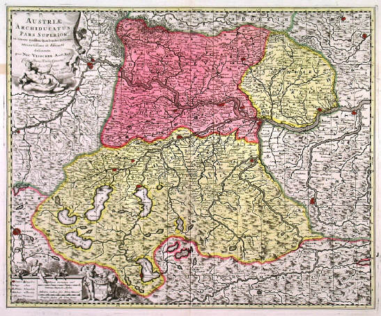
OBERÖSTERREICH: 853. Visscher, N. / Schenk, P. ëAUSTRIAE ARCHIDUCATUS PARS SUPERIOR...í. Antique map of Upper Austria / Oberösterreich between Passau, Ybbs and Hallstätter See with figurative cartouche and scale of miles with cherubs. Published by Pieter Schenk junior from the plate by Nicolaas Visscher ca. 1720 [22488] 46†x†56†cm. The map in full original colour. Excellent condition. £150
SALZBURG: 854. Homann, J. B. ëS.R.I. PRINCIPATUS ET ARCHIEPISCOPATUS SALISBURGENSIS...í. Antique map of the Salzburg region in Austria with very large pictorial cartouches, small table of explanations and small inset map. Johann Baptist Homann ca. 1720 [23298] 48†x†58†cm. The map in full original colour. Excellent condition. £350
WIEN: 858. Sanson, N. / Jaillot, H. ëPLAN DE LA VILLE DE VIENNE ET SES ENVIRONSí. Antique map of Vienna and its environs about 20km around with cartouche, small table of explanations and scale of miles. Printed on two sheets and joined and published by Hubert Jaillot after Nicolas Sanson 1692 [24167] 47†x†65†cm. Uncoloured. Excellent condition. £200
WIEN: 861. Illustrated London News. ëVIENNAí. Panorama of Vienna, showing the International Exhibition Buildings. Illustrated London News 1873 [21522] 32 x 75 cm. Uncoloured. Previously folded. Excellent condition. £120
<Back to Catalogues>