POLAND:884. Merian, Matthaeus. ‘POLONIA REGNUM, ET SILESIA DUCATUS’. Map of Poland as in its present borders with title cartouche and two heraldic shields. Engraved by Merian and published by Johann Ludwig Gottfried in Frankfurt 1646 [20139] 27 x 35 cm. Excellent condition. £250
Uncoloured as originally published. |
 |
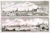
TALLINN / NARVA:885. Merian, Matthaeus. ‘REVALIA. REVELN’ / ‘NERVA’. 2 panoramic views of Tallinn (formerly ‘Reval’) and Narva in Estonia. Explanations from A - L and A - E respectively, one above the other on one double page. Engraved by Merian and published by Johann Ludwig Gottfried in Frankfurt 1646 [20018] 10 x 32 cm each. Excellent condition. The two together £200
Uncoloured as originally published. |
 |
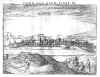
RIGA:886. Merian, Matthaeus. ‘RIGA’. Birds-eye view/plan of Riga in Latvia with the fortifications and numerous sailing ships in the
harbour. Explanations from A - O. Engraved by Merian and published by Johann Ludwig Gottfried in Frankfurt 1646 [20017] 22 x 26 cm. Excellent condition. £200
Uncoloured as originally published. |
 |
ELBLAG / POLAND:886A. Merian, Matthaeus. ‘WAHRE CONTRAFACTUR DER STATT
ELBING...’. Half birds-eye view/plan of Elblag in Poland with its fortifications and explanations from A - S below. Engraved by Merian and published by Johann Ludwig Gottfried in Frankfurt 1646 [20016] 23 x 32 cm. Excellent condition. £120
Uncoloured as originally published. |
 |
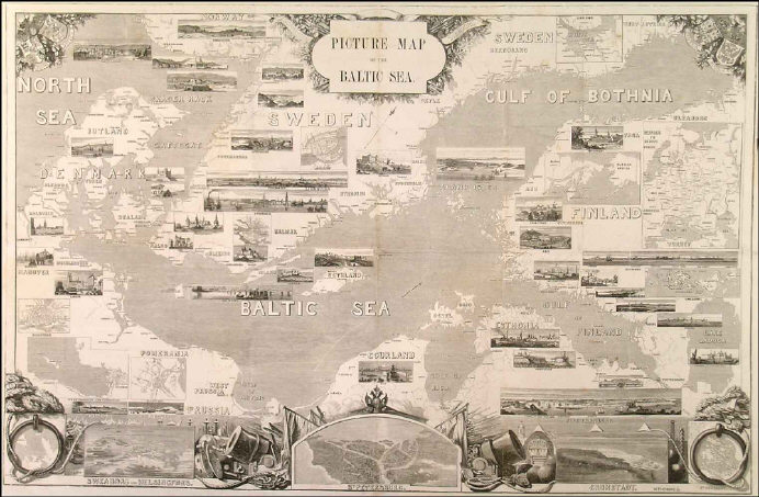
BALTIC SEA:887. Johnson, E. K. ‘PICTURE MAP OF THE BALTIC SEA’. Large map of the Baltic Sea and adjacent countries (Denmark, Sweden, Finland, Estonia, Latvia, Lithuania, Poland, Germany) with numerous vignettes to illustrate the respective capitals and major ports
(Lubeck, Riga, Reval, Helsinki, Stockholm, Copenhagen, etc), some inset town plans and small maps, and decorative cartouches, coats of arms, and naval related artwork. Woodengraved supplement by E. K. Johnson for the Illustrated London News 1856 [21411] 49 x 76 cm.
Uncoloured. Previously folded. Excellent condition. £150
|
 |
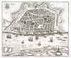
DANZIG - GDANSK:888. Bertius, P. ‘DANTZIG’. Panoramic view. Pieter Bertius ca. 1632 [26534] 14 x 19 cm. Uncoloured copper engraving. Excellent condition. £90
|
 |
DANZIG - GDANSK:889. Hulsius, Fr. ‘DANTZIG’. Small panoramic view of
Danzig. Friedrich Hulsius ca. 1632 [26536] 7 x 13 cm. Printed copper engraving,
uncoloured, on full folio text page. Slight overall agetoning. Excellent condition. £90
|
 |
ESTONIA - LATVIA:890. Blaeu, W. & J. ‘LIVONIA, VULGO LYEFLAND’. Antique map of Estonia
and Latvia with cartouche and sailing ships. Willem & Joan Blaeu 1639 [24959] 38 x 49 cm. Latin text verso. Original outline
colour. Excellent condition. £450
|
 |
ESTONIA - LATVIA:892. Letts, Son & Co. ‘RUSSIA’. Sheet No. 3 of Lett’s nine sheet map of Russia, showing Estonia, Latvia and parts of northern Lithuania. Letts’s Popular Atlas ca. 1884 [26834] 32 x 39 cm. Printed in
colours. Excellent condition. £150
|
 |
POLAND:893. Janssonius, J. / Schenk, P. & Valk, G. ‘MARCHIA NOVA VULGO NEW MARCK IN MARCH. BRANDENBURG’. Antique map of a small region in northwest Poland between
Stettin, Kalisz and Frankfurt/Oder with pictorial cartouche and scale of miles. North orientated to the left. Published by Pieter Schenk and Gerard Valk from the plate by Joannes Janssonius ca. 1700 [23301] 39 x 51 cm. The map in full original
colour. Excellent condition. £250
|
 |
POLAND:897. Letts, Son & Co. ‘RUSSIA (POLAND)’. Antique map of Poland, Warsaw in the
centre. Letts’s Popular Atlas ca. 1884 [26334] 38 x 31 cm. Printed in
colours. Excellent condition. £150
|
 |
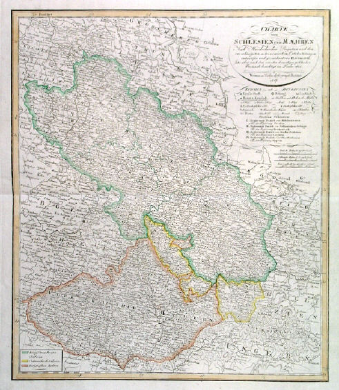
POLAND - SILESIA - CZECHIA:899. Geograph. Institut Weimar. ‘CHARTE VON SCHLESIEN UND
MAEHREN...’. Antique map of southwest Poland (Silesia) and Moravia. Verlag des Geograph. Instituts Weimar 1817 [25853] 54 x 46 cm. Original outline
colour. Excellent condition. £100
|
 |
|