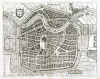
AMSTERDAM:899. Merian, Matthaeus. ĎAMSTERDAMí. Birds-eye view/plan of Amsterdam with numerous sailing ships in the harbour and two heraldic shields. Engraved by Merian and published by Johann Ludwig Gottfried in Frankfurt 1646 [20036] 27†x†35†cm. Excellent condition. £250
Uncoloured as originally published. |
 |
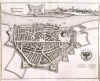
ANTWERPEN:900. Merian, Matthaeus.
ĎANTVERPIAí. Birds-eye view/plan of Antwerpen in Belgium with the fortifications. Explanations from 1 - 32. Engraved by Merian and published by Johann Ludwig Gottfried in Frankfurt 1646 [20007] 27†x†36†cm. Excellent condition. £150
Uncoloured as originally published. |
 |
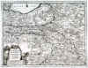
BENELUX:901. Merian, Matthaeus. ĎBELGII SIVE GERMANIA
INFERIORIS. NIDER TEUTSCHLANDTí. Map of Belgium, Netherlands, Luxembourg and parts of northwest Germany. North orientated to the right. Engraved by Merian and published by Johann Ludwig Gottfried in Frankfurt 1646 [20143] 28†x†36†cm. Excellent condition. £150
Uncoloured as originally published. |
 |
KAMPEN:902. Merian, Matthaeus. ĎCAMPIA. CAMPENí. Half birds-eye view/plan of Kampen in Holland. Engraved by Merian and published by Johann Ludwig Gottfried in Frankfurt 1646 [20034] 21†x†33†cm. Excellent condition. £120
Uncoloured as originally published. |
 |
DORDRECHT / BRIELLE:903. Merian, Matthaeus. ĎDORDRACUMí / ĎBRIELAí. 2 birds-eye views/plans of Dordrecht and Brielle in Holland, one above the other on one double page. Engraved by Merian and published by Johann Ludwig Gottfried in Frankfurt 1646 [20009] 15†x†25†cm and 13†x†25†cm respectively. Excellent condition. The two together £100
Uncoloured as originally published. |
 |
ENKHUIZEN:904. Merian, Matthaeus. ĎENCKHUYSENí. Birds-eye view/plan of Enkhuizen in Holland with the fortifications and sailing ships. Johann Ludwig Gottfried in Frankfurt 1646 [20011] 25†x†28†cm. Excellent condition. £120
Uncoloured as originally published. |
 |
GRONINGEN:905. Merian, Matthaeus. ĎGRONINGAí. Birds-eye view/plan of Groningen in Holland with the fortifications. Engraved by Merian and published by Johann Ludwig Gottfried in Frankfurt 1646 [20006] 28†x†34†cm. Excellent condition. £150
Uncoloured as originally published. |
 |
HAARLEM:906. Merian, Matthaeus. ĎHAERLEMAí. Birds-eye view/plan of Haarlem in Holland with the fortifications. Engraved by Merian and published by Johann Ludwig Gottfried in Frankfurt 1646 [20008] 21†x†26†cm. Excellent condition. £150
Uncoloured as originally published. |
 |
LEIDEN:907. Merian, Matthaeus. ĎLEYDAí. Birds-eye view/plan of Leiden in Holland with the fortifications. Engraved by Merian and published by Johann Ludwig Gottfried in Frankfurt 1646 [20012] 21 x†32†cm. Excellent condition. £150
Uncoloured as originally published. |
 |
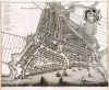
NIJMEGEN:908. Merian, Matthaeus. ĎNEOMAGUM. NÜMMEGENí. Birds-eye view/plan of Nijmegen in Holland with its fortifications and a small prospect of the town above. Engraved by Merian and published by Johann Ludwig Gottfried in Frankfurt 1646 [20035] 28 x†36†cm. Excellent condition. £175
Uncoloured as originally published. |
 |
ROTTERDAM:909. Merian, Matthaeus. ĎROTTERDAMí. Birds-eye view of Rotterdam in Holland with numerous sailing ships in the foreground and armorial cartouche. Engraved by Merian and published by Johann Ludwig Gottfried in Frankfurt 1646 [20145] 28†x†35†cm. Excellent condition. £250
Uncoloured as originally published. |
 |
ZUTPHEN:910. Merian, Matthaeus. ĎZUTPHANIAí. Birds-eye view/plan of Zutphen in Holland with the fortifications. Engraved by Merian and published by Johann Ludwig Gottfried in Frankfurt 1646 [20013] 25†x†29†cm. Excellent condition. £120
Uncoloured as originally published. |
 |
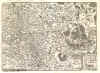
BELGIUM:912. Quad, M. ĎNAMURCUM ADIACENTIBUS REGIONIBUS
DESR. NAMENí. Antique map of the Belgian region of Namur. Johann Bussemacher for Matthias Quad 1589 [21278] 20†x†27†cm. Title cartouche. Excellent condition. £100
|
 |
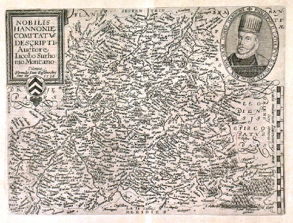
BELGIUM:913. Quad, M. ĎNOBILIS HANNONIE
COMITATUS...í. Region of Hainot in the Belgian - French border area around
Tournai, Charleroi and Valenciennes. Johann Bussemacher for Matthias Quad 1596 [21279] 23 x†30 cm. Title cartouche, oval portrait of Philipp II, and scale of miles. Excellent condition. £100
|
 |
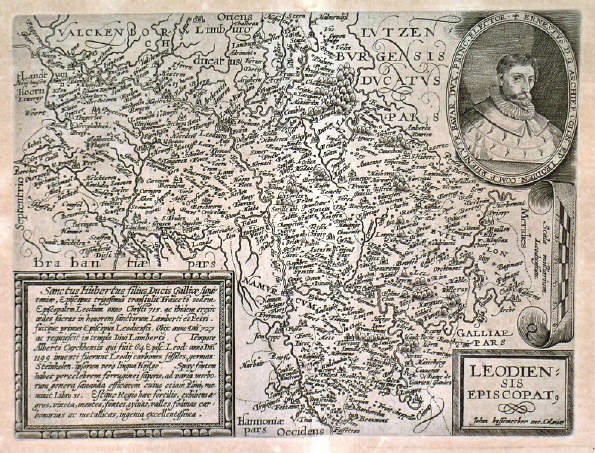
BELGIUM:914. Quad, M. ĎLEODIENSIS EPISCOPAT.í. Antique map of southeastern Belgium around Liege. Johann Bussemacher for Matthias Quad ca. 1600 [21282] 20†x†26†cm. Title cartouche, table of explanations, oval portrait, and scale of miles. Overall slight age toning. £100
|
 |
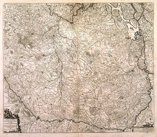
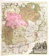
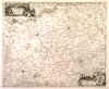
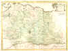
BRABANT:923. Visscher, N. ĎTABULA DUCATUS
BRABANTIAE....í. Antique map of Brabant, the part Belgian, part Dutch region between Brussels,
Dordrecht, Venlo and Liege, north orientated to the right. Small cartouche and scale of miles. Nicolaas Visscher ca. 1685 [21862] 47†x†55†cm.
Uncoloured. slight browning in the white margins. Very good condition. £100
|
 |
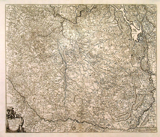
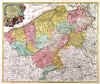
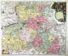
BRABANT:924. De Wit, F. ĎTABULA DUCATUS BRABANTIAE CONTINENS MARCHIONATUM SACRI IMPERII ET DOMINIUM MECHLINIENSEí. Antique map of the whole region of Brabant, partly in Holland and partly in Belgium, reaching as far as
Breda, Hertogenbosch, Venlo, Liege and Brussels. North orientated to the right. Small cartouche. Frederic De Wit ca. 1690 [21902] 46†x†54†cm.
Uncoloured. Central papercrease flattened, otherwise very good condition. £100
|
 |
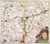
BRABANT:925. Schenk, P. ĎBRABANTIAE DUCATUSí. Antique map of Brabant, a province now partly in the Netherlands and partly in Belgium, including towns like Brussels, Antwerp,
Breda, Venlo, Maastricht and Namur. Figurative dedication cartouche. Pieter Schenk ca. 1705 [21919] 56†x†48†cm. The map in full original
colour. Excellent condition. £100
|
 |
BRUGES:927. Coney, J. ĎCLOTH HALL - BRUGESí. A busy market scene in front of the Cloth Hall, Bruges. Etched and engraved by John Coney, London ca. 1840 [24896] 47 x 39 cm.
Full hand colour. Excellent condition. £100
|
 |
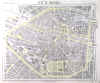
BRUXELLES:929. Letts, Son & Co. ĎCITY OF BRUSSELSí. Plan of Brussels. Lettsís Popular Atlas ca. 1884 [26327] 31†x†38†cm. Printed in
colours. Excellent condition. £50
|
 |
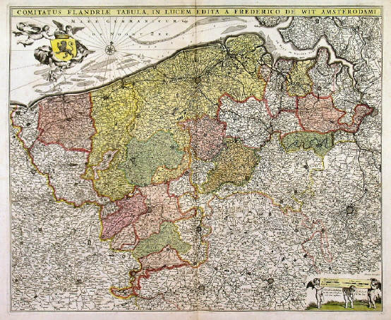
FLANDERS:932. De Wit, F. ĎCOMITATUS FLANDRIAE TABULAí. Antique map of Flanders, the whole Belgian region northwest of Brussels, confined by Antwerp, Brussels,
Valenciennes, Arras, St. Omer and the Channel. Title heading above the map, coat of arms supported by cherubs, and scale of miles. Frederic De Wit ca. 1690 [21903] 45†x†55†cm. Full original
colour. Excellent condition. £150
|
 |
FLANDERS:935. Visscher, N. ĎFLANDRIAE COMITATUS PARS MEDIA.....í. Antique map of central Flanders, the Belgian region between Gent,
Oudenaarde, Kortrijk, Ieper and Diksmuide. Title heading above the map. Nicolaas Visscher ca. 1700 [21871] 46†x†56†cm. Full original
colour. Excellent condition. £150
|
 |
FLANDERS:938. Homann, J. B. ĎCOMITATUS FLANDRIAEí. Antique map of Flanders, the whole Belgian region northwest of Brussels, confined by Antwerp, Brussels,
Valenciennes, Arras, St. Omer and the Channel. Pictorial cartouche with coat of arms and cherubs. Johann Baptist Homann ca. 1720 [23871] 48†x†57†cm. Full original
colour, incl. cartouche. Excellent condition. £150
|
 |
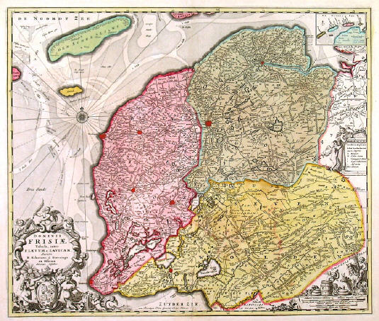
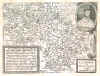
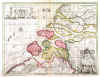
FRIESLAND - GRONINGEN - DRENTHE:939. Visscher, N. ĎDOMINII FRISIAE
TABULA, INTER FLEVUM ET LAVICAMí. Detailed map of Friesland, Groningen and
Drenthe, the northeastern provinces of the Netherlands, with three figurative cartouches with numerous cherubs, compass rose, and small inset map of the islands of
Vlieland, Terschelling, Ameland and Schiermonnikoog. Nicolaas Visscher ca. 1685 [21878] 47†x†56†cm. The map in full original
colour. Short split and few paper cracks to lower centrefold expertly repaired, otherwise very good condition. £150
|
 |
FRIESLAND - GRONINGEN - DRENTHE:941. Güssefeld, F. L. / Homann Heirs. ĎCHARTE VON FRIESLANDí. Antique map of
Friesland, Groningen and Drenthe, provinces in northern Holland. Published by Homann Heirs after Franz Ludwig Güssefeld 1786 [21936] 47†x†57†cm. The map in full original
colour. Overall agetoning, otherwise good condition. £100
|
 |
GELDERLAND:942. Quad, M. (GELDRIA). Antique map of Gelderland in eastern Holland between
Kampen, Wesel, Roermond, Eindhoven and Utrecht. Johann Bussemacher for Matthias Quad ca. 1600 [21271] 28†x†27†cm. Table of explanations. North orientated to the right. Excellent condition. £125
|
 |
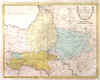
GELDERLAND:944. De Wit, F. ĎDUCATUS GELDRIAE ET COMITATUS ZUTPHANIAE TABULAí. Antique map of the Dutch region of Gelderland between
Ijsselmeer, Hertogenbosch and Wesel. Armorial cartouche and scale of miles, title heading aove the map. North orientated to the right. Frederic De Wit ca. 1690 [21901] 46†x†54†cm.
Uncoloured. Excellent condition. £150
|
 |
GELDERLAND:945. Aa, P. v. d. ĎLA GUELDRE, SUIVANT LES NOUVELLES OBSERVATIONSí. Antique map of
Gelderland, the Dutch province, with pictorial cartouche. Pieter van der Aa, Leiden 1714 [25096] 23†x†30†cm.
Uncoloured. Excellent condition. £120
Folio edition - no
centrefolds. |
 |
|
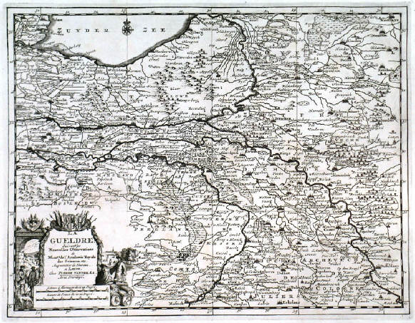
GELDERLAND:946. Ottens, J. ĎDUCATUS GELDRIAE NOVA TABULA ....í. Antique map of
Gelderland, the central Dutch province, reaching from the Ijsselmeer to Roermond. Figurative cartouche. Joachim Ottens ca. 1725 [21911] 59†x†49†cm. The map in full original
colour. Excellent condition. £150
|
 |
GELDERLAND:947. Güssefeld, F. L. / Homann Heirs. ĎCHARTE VON GELDERLAND UND DER DAZUGEHÖRIGEN GRAFSCHAFT ZUTPHENí. Antique map of Gelderland and
Zutphen, provinces in eastern Holland, reaching from Kampen to Enschede,
Emmerich, Bommel and Utrecht. Published by Homann Heirs after Franz Ludwig Güssefeld 1787 [21935] 45†x†58†cm. The map in full original
colour. Overall agetoning, otherwise good condition. £100
|
 |
GRONINGEN:949. Aa, P. v. d. ĎLA GRONINGUE, SUIVANT LES NOUVELLES OBSERVATIONSí. Antique map of
Groningen, the Dutch province, with pictorial cartouche. Pieter van der Aa, Leiden 1714 [25099] 23†x†30†cm.
Uncoloured. Excellent condition. £100
Folio edition - no
centrefolds. |
 |
|
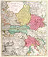
HOLLAND:952. Homann Heirs. ĎTABULA COMITATUS
HOLLANDIAE...í. Antique map of Holland, the northwest province of The Netherlands between North Sea, Zuyder Sea and the
Waal, with Amsterdam in the centre. Large pictorial cartouche. Homann Heirs 1733 [24031] 57†x†49†cm. Full original
colour, incl. cartouche. Excellent condition. £350
|
 |
LIMBURG:956. Visscher, N. ĎLIMBURGI DUCATUS ET COMITATUS VALCKENBURGI NOVA DESCRIPTIOí. Detailed map of the close Belgian area between Liege,
Maastricht, Aachen and Verviers, north orientated to the right. Pictorial cartouche and scale of miles. Nicolaas Visscher ca. 1685 [21863] 47†x†56†cm.
Uncoloured. Excellent condition. £100
|
 |
MAASTRICHT:962. Aa, P. v. d. ĎLE DUCHÉ DE
LIMBOURG, SUIVANT LES NOUVELLES OBSERVATIONSí. Antique map of the area around Maastricht in the Netherlands, reaching east to
Aachen/Germany and south to Limbourg/Belgium, with pictorial cartouche. Pieter van der Aa, Leiden 1714 [25104] 23†x†30†cm.
Uncoloured. Excellent condition. £100
Folio edition - no
centrefolds. |
 |
|
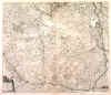
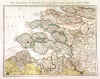
MONS:964. Visscher, N. ĎCOMITATUS HANNONIAE
TABULA....í. Antique map of the area around the Belgian city of Mons in the southwest of Brussels, including
Tournai, Charleroi, Maubeuge and Valenciennes. Figurative cartouche and scale of miles. Nicolaas Visscher ca. 1685 [21866] 46†x†58†cm.
Uncoloured. Excellent condition. £100
|
 |
MONS - TOURNAI:965. Seutter, M. ĎACCURATA
DELINEAT. COMITATUS HANOVIAE BELGII AUSTRIACI PROVINC. ...í. Detailed map of the Belgian / French border area around
Mons, Tournai, Ath, Charleroi (Belgium) and Valenciennes, Cambrai, Maubeuge (France) with figurative cartouche. Matthaeus Seutter ca. 1730 [25912] 48†x†57†cm. Full original
colour, incl. cartouches. Excellent condition. £100
|
 |
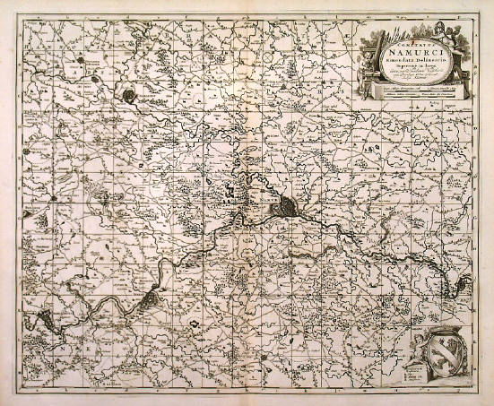
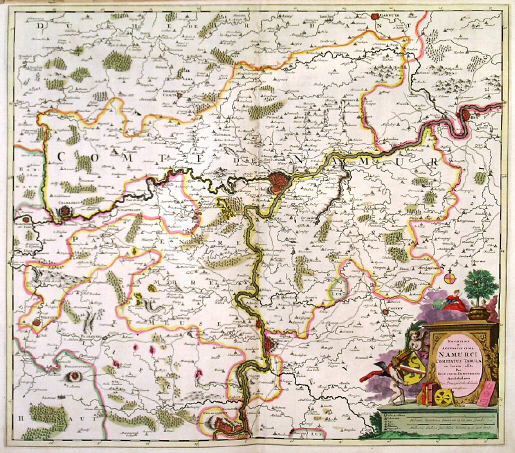
NAMUR:966. Visscher, N. ĎCOMITATUS NAMURCI EMENDATA
DELINEATIO....í. Antique map of the area around the Belgian city of Namur, reaching to Charleroi, Huy and
Charlemont. Decorative cartouche and coat of arms. Nicolaas Visscher ca. 1685 [21865] 46†x†56†cm.
Uncoloured. Small rust spot in the title cartouche. Very good condition. £100
|
 |
NAMUR:967. Danckerts, J. ĎNOVISSIMA ET ACCURATISSIMA NAMURCI COMITATUS
TABULA...í. Detailed map of the area around Namur in Belgium, reaching to Charleroi, Huy and
Dinant, with decorative cartouche. Justinus Danckerts ca. 1690 [21905] 51†x†57†cm. Full original
colour, incl. cartouche. Excellent condition. £100
|
 |
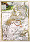
NETHERLANDS:969. Bowen, E. ĎA NEW AND ACCURATE MAP OF THE SEVEN UNITED PROVINCES..í. Antique map of the Netherlands with pictorial cartouche and a smaller map below of the North Sea / The Channel between Zeeland and the Thames Estuary, showing the sands, soundings, bearings etc. Emanuel Bowen ca. 1766 [26907] 31†x†22†cm. Recent outline
colour. Excellent condition. £125
|
 |
NETHERLANDS:970. Cary, J. ĎA NEW MAP OF THE UNITED PROVINCES, COMPREHENDING HOLLAND, ZEALAND, UTRECHT,
GELDERS, OVER YSSEL, FRIESLAND AND GRONINGEN...í. Antique map of The Netherlands. John Cary 1799 [26154] 46†x†52†cm. Full original
colour. Excellent condition. £100
|
 |
NETHERLANDS:971. Thomson, J. ĎHOLLANDí. Doublepage map of The Netherlands. John Thomson 1814 [19352] 59†x†50†cm. Full original
colour. Excellent condition. £90
|
 |
NETHERLANDS:972. Weiland, C. F. ĎGENERAL CHARTE VON DEM KÖNIGREICHE DER NIEDERLANDE NEBST DEM GROSSHERZOGTHUME LUXEMBURG...í. Antique map of The Netherlands and Luxembourg, divided into provinces. Carl Ferdinand Weiland for Verlag des Geograph. Instituts Weimar 1817 [25827] 56†x†44†cm. Original outline
colour. Excellent condition. £100
|
 |
UTRECHT:977. Güssefeld, F. L. / Homann Heirs. ĎCARTE VON UTRECHTí. Detailed map of the area 25 km around Utrecht, reaching to
Bunschoten, Wageningen, Schoonhoven and Amsterdam. Published by Homann Heirs after Franz Ludwig Güssefeld 1787 [21934] 42†x†57†cm. The map in full original
colour. Excellent condition. £100
|
 |
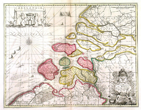
ZEELAND:978. Pitt, M. ĎZEELANDIA COMITATUSí. Antique map of Zeeland, the southwestern part of The Netherlands. Figurative title and dedication cartouches, compass rose, sailing ships. Published after the map by Joannes Janssonius by Moses Pitt ca. 1681 [21912] 38†x†49†cm. The map in full original
colour. Excellent condition. £150
|
 |
ZEELAND:980. Weigel, C. u. Schneider, A. G. ĎNEUE
SPECIAL-CHARTE VON ZEELAND UND DER OST- UND WESTER-SCHELDEí. Detailed map of Zeeland, the southwestern part of The Netherlands. Christoph Weigel and Adam Gottlieb Schneider 1785 [21913] 31†x†41†cm. Original outline
colour. Excellent condition. £150
Separately published. Rare. - Weigel and Schneider, publishers in Nürnberg. |
 |
|
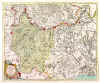
ZUTPHEN:981. Visscher, N. ĎNOVISSIMA COMITATUS ZUTPHANIAE TOTIUSQE FLUMINUS ISULAE DESCRIPTIOí. Antique map of the central Dutch region of
Zutphen, confined by the towns of Kampen, Coevorden, Enschede and Nijmegen. North orientated to the right. Decorative cartouche and scale of miles with coat of arms supported by cherubs above. Nicolaas Visscher ca. 1685 [21882] 46†x†56†cm. Full original
colour. Excellent condition. £150
|
 |