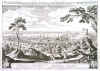
BRATISLAVA:996. Merian, Matthaeus. ‘TOPOGRAPHIA REGIAE LIBERAEQUE CIVITATIS POSONIENSIS VULGO PRESSBURG HUNGARIAE SUPERIORIS AD DANUBIUM
SITA...’. Highly decorative panoramic view of Bratislava in Slovakia. Explanations from 1 - 8 below. Engraved by Merian and published by Johann Ludwig Gottfried in Frankfurt 1646 [20020] 24 x 35 cm. Excellent condition. £175
Uncoloured as originally published. |
 |
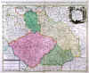
CZECHIA:997. Homann, J. B. ‘MARCHIONATUS MORAVIAE CIRCULUS
HRADISTIENSIS...’. Detailed map of Moravia, the southeastern part of the Czech Republic. Large pictorial cartouche, showing some trades and produce of the region. Published after Johann Christian Müller by Johann Baptist Homann ca. 1720 [22522] 49 x 58 cm. The map in Full original
colour. Occasional spotting and discoloration around the major places indicated in red, otherwise in very good condition. £150
|
 |
CZECHIA - SILESIA:998. Sanson, N. / Schenk, P. ‘ESTATS DE LA COURONNE DE
BOHEME... / LE ROYAUME DE BOHEME, DUCHÉ DE SILESIE, LES MARQUISAT DE MORAVIE ET DE LUSACE’. Antique map of the Czech Republic with Moravia and Silesia in southern Poland. Figurative cartouche and scale of miles. Published by Pieter Schenk from the plate by Nicolas Sanson ca. 1720 [23302] 48 x 58 cm. The map in full original
colour. Excellent condition. £100
|
 |
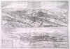
PRAGUE:999. Braun, G. & F. Hogenberg. ‘PRAGA, BOHEMIAE METROPOLIS ACCURATISSIME EXPRESSA’.
Panoramic view of Prague in the Czech Republic. Latin text verso. Published by Georg Braun and Frans Hogenberg in Civitates Orbis Terrarum
in Cologne ca. 1575 [29732] 18 x 47 cm. Full
recent colour. Excellent condition. £375
Prospect of Prague
(Praha) and Eger (Cheb), published in the first volume of Braun & Hogenberg's
'Civitates Orbis Terrarum', the first systematic series of printed townplans. |
 |
|


