CANADIAN RAILWAYS:1584. Anonymous. ‘MAP OF THE CANADIAN PACIFIC RAILWAY, THE MINNEAPOLIS, ST.PAUL & SAULT STE. MARIE RAILWAY, THE SPOKANE INTERNATIONAL RAILWAY AND CONNECTIONS’. Large comprehensive railroad map showing the main routes with inset of connections to Steamship Lines. Poole Bros. Chicago 1926 [25025] 46 x 101 cm. Full original
colour. Some slight damage to one or two folds, but still in good condition. £140
|

 |
EAST CANADA:1585. Bellin, N. / Homann Heirs. ‘PARTIE ORIENTALE DE LA NOUVELLE FRANCE OU DU CANADA’. Map of East Canada, New Brunswick, Nova Scotia, Newfoundland and the US State of Maine. Published by Homann Heirs after Nicolas Bellin 1755 [29139] 43 x 54 cm. Original outline
colour. Excellent condition. £300
|
 |
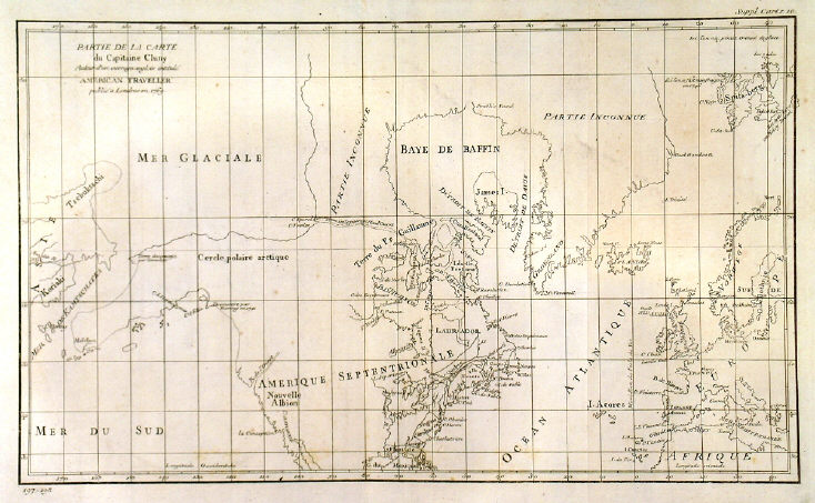
NORTH-WEST PASSAGE:1591. (De Vaugondy, R.). ‘PARTIE DE LA CARTE DU CAPITAINE CLUNY AUTEUR D’UN OUVRAGE ANGLOIS INTITULÉ AMERICAN TRAVELLER PUBLIÉE À LONDRES EN 1769’. Northern Western hemisphere on Mercator’s projection showing North America and Europe and the supposed North-West passage between Hudson and Baffin Bay and the Arctic Ocean. A short ‘R. de l’Ouest’ is indicated from the Californian coast inland. Robert de Vaugondy after Cluny’s map of 1769,
publ. in Diderot’s Encyclopaedia ca. 1773 [17836] 21 x 41 cm.
Uncoloured. Left margin trimmed to neatline. £140
Smaller version of Pedley 460. |
 |
|
NORTH-WEST PASSAGE:1592. (De Vaugondy, R.). ‘PARTIE DE LA CARTE DU CAPITAINE CLUNY AUTEUR D’UN OUVRAGE ANGLOIS INTITULÉ AMERICAN TRAVELLER PUBLIÉE À LONDRES EN 1769’. Northern Western hemisphere on Mercator’s projection showing North America and Europe and the supposed North-West passage between Hudson and Baffin Bay and the Arctic Ocean. A short ‘R. de l’Ouest’ (River) is indicated from the Californian coast inland. Robert de Vaugondy after Cluny’s map of 1769,
publ. in Diderot’s Encyclopaedia ca. 1773 [21378] 29 x 49 cm.
Uncoloured. Excellent condition. £175
Pedley 460. |
 |
|
QUEBEC:1595. London Magazine. ‘A PLAN OF THE RIVER ST. LAWRENCE, FROM THE FALLS OF MONTMORENCI TO
SILLERY; WITH THE OPERATIONS OF THE SIEGE OF QUEBEC’. Detailed plan with numerous war ships and small inset plan of the ‘Action gained by the English near Quebec, Sep. 13, 1759’. London Magazine 1760 [19803] 18 x 24 cm. Large cartouche.
Uncoloured. Excellent condition. £125
|
 |
QUEEN CHARLOTTE ISLANDS:1596. Admiralty Charts. ‘ENGLEFIELD BAY AND APPROACHES’, ‘HOUSTON STEWART CHANNEL’, ‘CUMSHEWA INLET’, and four other sea charts of other Queen Charlotte Islands (off the Canadian West coast) on one double map sheet. Compiled from earlier Canadian Government Charts under the Superintendence of Rear Admiral A. Day at the Admiralty 1952 [26434] 97 x 65 cm.
Uncoloured. Excellent condition. £120
|
 |