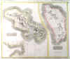
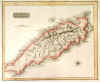
BARBADOS:313. Homann Heirs. ĹINSULA BARBADOES IN SUAS PAROCHIAS
DISTINCTA...ĺ. Detailed map of Barbados, north orientated to the left. Homann Heirs ca. 1740 [24553] 22áxá28ácm. Left, lower and upper border trimmed to neatline as issued and margins extended. Original outline
colour. Excellent condition. £150
|
 |
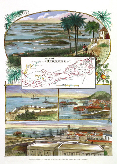
BERMUDA:315. Anonymous. ĹVIEWS IN BERMUDA...ĺ. Small map of Bermuda, surrounded by four views of Grassy Bay Fort, St. Georgeĺs Town, Dockyard Hulks, and View of Islands from Gibbs Hill (the latter in oval pictorial framework). Full page woodengraved illustration from the Illustrated London News 1890 [21410] 32áxá23ácm.
Full hand colour. Excellent condition. £150
|
 |
BERMUDA - JAMAICA:317. Crépy, J. ĹLA BERMUDE AUX ANGLOISĺ and ĹLA JAMAIQUE AUX
ANGLOIS...ĺ. Two maps on one sheet. Crepy in Paris 1767 [17850] 21áxá28ácm. Original outline
colour, the border line in a crude yellow, the seas in faint contemporary green. Occasional browning and
agetoning, otherwise very good condition. £130
This is a close copy of Le Rougeĺs map of 1746, but more uncommon. |
 |
|
CENTRAL AMERICA:320. Tallis, J. 'CENTRAL AMERICA'. Antique map of Guatemala, Honduras and Nicaragua. John Tallis ca. 1851 [14656] 25áxá35ácm. Original outline
Colour. Excellent condition. £60
|
 |
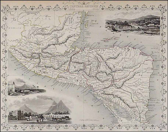
CENTRAL AMERICA:322. Macnab, J. ĹCENTRAL AMERICA, NAMELY THE (LATE) CONFEDERATED STATES OF CENTRAL AMERICA; THE MEXICAN STATES OF
CHIAPA, TABASCO & YUCATAN; AND BRITISH HONDURASĺ. Antique map of Central America. Engraved by John Bartholomew and published by Archibald Fullarton after John Macnab ca. 1872 [25908] 52áxá40ácm.
Full hand colour. Excellent condition. £220
|
 |
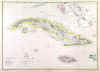
CUBA:325. Ettling, T. ĹCUBA AND JAMAICAĺ. Detailed map of Cuba, reaching as far as Cayman Islands, Jamaica, parts of the Bahama Islands, and the Florida Keys. Theodor Ettling for Weekly Dispatch Atlas ca. 1860 [17185] 30áxá43ácm. Original outline
colour. Excellent condition. £60
|
 |
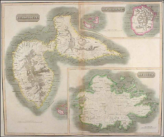
GUADELOUPE, ANTIGUA and MARIE GALANTE:326. Thomson, J. ĹGUADELOUPEĺ / ĹANTIGUAĺ / ĹMARIEGALANTEĺ. 3 detailed maps on one sheet. Kirkwood for Thomson ca. 1816 [19316] 50áxá59ácm. Original outline
colour. Excellent condition. £120
|
 |
JAMAICA:329. Thomson, J. ĹJAMAICAĺ. Detailed map with two large insets of ĹThe Harbour of Bluefieldsĺ and ĹThe Harbours of Kingston and Port Royalĺ. Engraved by Thomas Clerk for John Thomson ca. 1814 [25974] 43áxá60ácm. Full later
colour. Excellent condition. £160
|
 |
MARTINIQUE and DOMINICA:331. Thomson, J. ĹMARTINICOĺ / ĹDOMINICAĺ. Two detailed maps of Martinique and Dominica on one sheet, inset map of the bay of Fort de France. Engraved by Kirkwood & Son for John Thomson ca. 1816 [19315] 50áxá59ácm. Original outline colour with some recent additions. Excellent condition. £120
|
 |
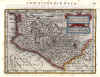
MEXICO:332. Quad, M. ĹHISPANIAE NOVAE SIVE MAGNAE VERA DESCRIPTIOĺ. Antique map of central Mexico. Johann Bussemacher for Matthias Quad ca. 1600 [21300] 21 xá29ácm. Title cartouche and two large tables of explanations.
Full hand colour. Excellent condition. £350
|
 |
MEXICO:333. Mercator, G. / Janssonius, J. 'HISPANIAE NOVAE NOVA
DESCRIPTIO'. Central Mexico with Mexico City and Guadalajara. Petrus Kaerius for Mercator/Janssonius 1648 [23750] 14áxá19ácm. Recent outline
colour. Excellent condition. £280
|
 |
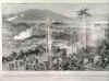
SPANISH - AMERICAN WAR:343. The Graphic. ĹPANORAMIC VIEW OF THE GREAT BATTLE OF THE SPANISH - AMERICAN WAR: The general assault on Santiago de Cuba on July 1st.Ĺ From a sketch by D.
Macpherson. Drawn by J. Gulich, R. I. & C. J. Staniland, R.I. The Graphic 1898 [21530] 33 x 105 cm. Uncoloured as issued. Folded. very good condition. £75
|
 |
ST. KITTS:344. Edwards, B. ĹMAP OF THE ISLAND OF ST. CHRISTOPHERĺS for the History of the West Indies by Bryan Edwardsĺ published by John Stockdale 1794 [26390] 18áxá23ácm. Full original
colour. Few vertical folds flattened, otherwise very good condition. £120
|
 |
TOBAGO:346. Thomson, J. ĹTOBAGOĺ. Antique map of the island of Tobago. John Thomson 1816 [19295] 25áxá30ácm. Original outline
colour. Excellent condition. 2áborders extended (remargined). £75
|
 |
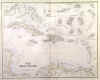
WEST INDIES:353. Swanston, G. H. ĹTHE WEST INDIESĺ. Doublepage map with numerous insets of the Ĺmost important of the Lesser British islandsĺ (Bermuda, Virgin Islands, Grenada,
Barbadoes, Tobago, St. Kitts, Antigua. St. Vincent, St. Lucie, etc). Engraved by George H. Swanston and published by Archibald Fullarton ca. 1850 [25596] 41áxá51ácm. Original outline
colour. Excellent condition. £175
|
 |
WEST INDIES:354. Letts, Son & Co. ĹTHE ANTILLES, OR WEST INDIESĺ. Antique map of the West Indies with southern Florida, the Bahamas and parts of Central America, showing the warm and cold currents, submarine cables, lighthouses, and (mostly extinct) volcanoes. Lettsĺs Popular Atlas ca. 1884 [26321] 30áxá38ácm. Printed in
colours. Excellent condition. £50
|
 |
|