ASTRONOMY:53. Johnston, A. K. [EXPLANATION OF ASTRONOMICAL PLATES]. Set of six large astronomical plates, printed on three leaves, with corresponding text pages, showing the celestial sphere and refraction, the solar system, the comets, the seasons, the eclipses of the sun, and the eclipses of the moon. Engraved and printed for The Cosmographic Atlas by W. & A. K. Johnston 1891 [25603] 32 x 42 cm each, with three pages of text. Printed in full
colours. Excellent condition. The complete set of six plates (printed double sided on three leaves) plus text £180
|
 |
CARICATURE MAPS: |
|
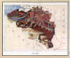
56E. Lancaster [Tennant], L. ‘BELGIUM’. Caricature map of Belgium, showing the horse Bayard saving the sons of
Aymon. Lilian Lancaster [Tennant] ca. 1910 [26341] 14 x 18 cm. Printed in full
colours. Excellent condition. £75
Lilian Lancaster (1852-1939), designer of humorous and unusual maps, attributing human and other living creatures’ forms and characteristics to maps, worked under her married name Lilian Tennant. |
 |
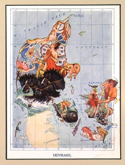
56F. Lancaster [Tennant], L. ‘DENMARK’. Caricature map of Denmark, showing the Elf King guarding the Danish coasts. Lilian Lancaster [Tennant] ca. 1910 [26342] 18 x 14 cm. Printed in full
colours. Excellent condition. £60
Lilian Lancaster (1852-1939), designer of humorous and unusual maps, attributing human and other living creatures’ forms and characteristics to maps, worked under her married name Lilian Tennant. |
 |
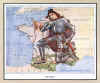
56G. Lancaster [Tennant], L. ‘FRANCE’. Caricature map of France, showing Jeanne d’Arc hearing the heavenly voices. Lilian Lancaster [Tennant] ca. 1910 [26343] 14 x 18 cm. Printed in full
colours. Excellent condition. £60
Lilian Lancaster (1852-1939), designer of humorous and unusual maps, attributing human and other living creatures’ forms and characteristics to maps, worked under her married name Lilian Tennant. |
 |
56H. Lancaster [Tennant], L. ‘GERMANY’. Caricature map of Germany, showing children following the Pied Piper of
Hamelin. Lilian Lancaster [Tennant] ca. 1910 [26344] 14 x 18 cm. Printed in full
colours. Excellent condition. £60
Lilian Lancaster (1852-1939), designer of humorous and unusual maps, attributing human and other living creatures’ forms and characteristics to maps, worked under her married name Lilian Tennant. |
 |
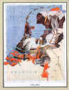
56J. Lancaster [Tennant], L. ‘HOLLAND’. Caricature map of The Netherlands, showing a stork mother sheltering her little ones in the burning city. Lilian Lancaster [Tennant] ca. 1910 [26345] 18 x 14 cm. Printed in full
colours. Excellent condition. £60
Lilian Lancaster (1852-1939), designer of humorous and unusual maps, attributing human and other living creatures’ forms and characteristics to maps, worked under her married name Lilian Tennant. |
 |
56K. Lancaster [Tennant], L. ‘ICELAND’. Caricature map of Iceland, showing a raven guiding Floke the viking across the Great Sea. Lilian Lancaster [Tennant] ca. 1910 [26346] 14 x 18 cm. Printed in full
colours. Excellent condition. £60
Lilian Lancaster (1852-1939), designer of humorous and unusual maps, attributing human and other living creatures’ forms and characteristics to maps, worked under her married name Lilian Tennant. |
 |
56L. Lancaster [Tennant], L. ‘RUSSIA’. Caricature map of Russia, showing little Tsar Peter being protected by his mother. Lilian Lancaster [Tennant] ca. 1910 [26347] 18 x 14 cm. Printed in full
colours. Excellent condition. £80
Lilian Lancaster (1852-1939), designer of humorous and unusual maps, attributing human and other living creatures’ forms and characteristics to maps, worked under her married name Lilian Tennant. |
 |
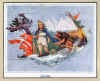
56M. Lancaster [Tennant], L. ‘SCANDINAVIA’. Caricature map of Scandinavia, showing Thor hurling his hammer at the sleeping giant. Lilian Lancaster [Tennant] ca. 1910 [26348] 18 x 14 cm. Printed in full
colours. Excellent condition. £80
Lilian Lancaster (1852-1939), designer of humorous and unusual maps, attributing human and other living creatures’ forms and characteristics to maps, worked under her married name Lilian Tennant. |
 |
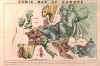
CARICATURE MAP OF EUROPE:56R. Anonymous. ‘COMIC MAP OF EUROPE’. Caricature map of Europe at the beginning of the Franco-Prussian War 1870. Subtitle: ‘England enraged forgets Ireland but still keeps it in her power. Spain & Portugal smoke away lazily. France tries to overthrow Prussia who advances one hand on Holland & knee over Austria. Italy advises Bismark to keep off. Corsica & Sardinia laugh on at all. Denmark hopes to recover Holstein. Turkey is drowsily awaking from smoke. Sweeden (sic!) crouching like a panther. Russia as a begger trying for anything to fill his basket’. Anonymous ca. 1870 [27774] 27 x 38 cm. Full original
colour. Previously folded. Despite some overall light roughness still in very good condition. £500
Besides being an example of a rare political caricature map, this map is also a document of postal history: It had been originally folded six times into a postcard size shape and posted from
Burnopfield, Co. Durham, to an address in Plymouth on October 24, 1870, where it arrived the next day. It still bears the half penny red stamp which was used. The folds have now been flattened and verso strengthened, almost invisible when viewed from the front. |
 |
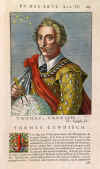
CAVENDISH:57. Bullart, I. ‘THOMAS CANDISCH’. Head and shoulder portrait of Thomas Cavendish, British circumnavigator, holding globe and dividers. From Isaac Bullart/Academie des Sciences et des Arts 1682 [22594] 17 x 13 cm, on folio text page with decorative initial J.
Full recent colour. Excellent condition. £120
|
 |
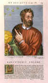
COLUMBUS:58. Bullart, I. ‘CHRISTOPHLE COLOMB’. Head and shoulder portrait of Christoph Columbus, holding a compass. From Isaac Bullart/Academie des Sciences et des Arts 1682 [22587] 17 x 13 cm, on folio text page with decorative initial L.
Full recent colour. Excellent condition. £150
|
 |
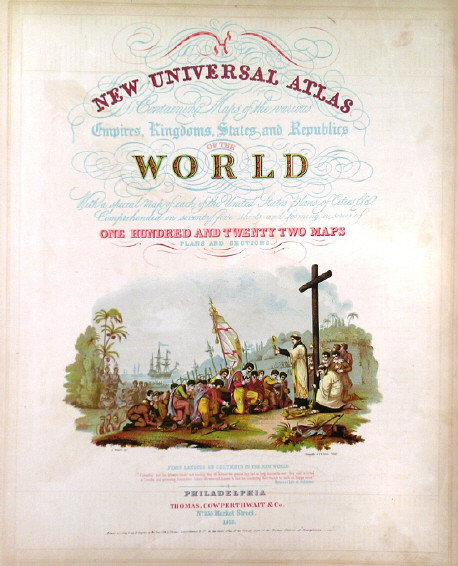
COLUMBUS:60. Thomas, Cowperthwait & Co. “NEW UNIVERSAL ATLAS CONTAINING MAPS OF THE VARIOUS EMPIRES, KINGDOMS, STATES AND REPUBLICS OF THE WORLD”. Title page only of this atlas with beautiful coloured illustration of the first landing of Columbus in the New World. Thomas, Cowperthwait & Co. 1852 - 1855 [25879] 39 x 30 cm. Coloured lithograph. Excellent condition. £60
|
 |
CURIOUSITY:61. Anonymous. ‘DURCHREIST DIE GANTZE WELT...’. A very strange group of ‘artiste’ performing odd activities, one of them holding a trumpet with a map of the West Indies, Central and South America attached. Anonymous ca. 1770 [20962] 20 x 31 cm. Full original
colour. Side and top margins closely trimmed to platemark. £150
The German text below this separately published caricature
says that you can travel the whole world without finding a similar group of ‘artists’ again, acting so proficiently that ‘you have to admit, it is truly here where the arts and graces have their home’. |
 |
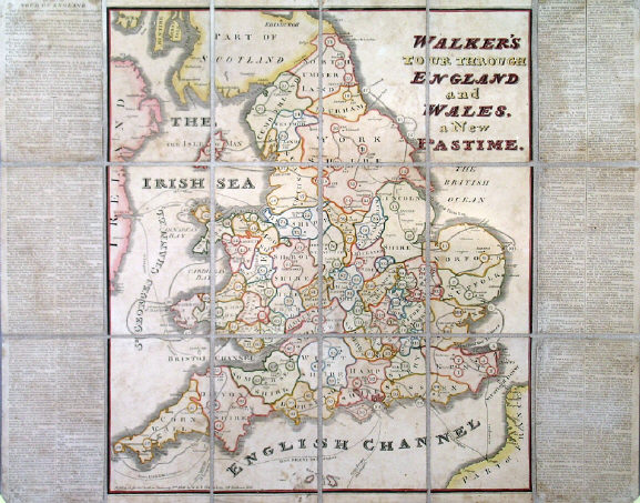
EDUCATIONAL GEOGRAPHICAL GAME:62. Darton, W. & T. ‘WALKER’S TOUR THROUGH ENGLAND AND WALES, A NEW PASTIME’. Folding map of England and Wales with rules and explanations printed in double coumns down each side, published to accompany a set of ‘pyramids’ and ‘counters’ and a dice (accessories here not present), to proceed from starting point Maidstone in Kent via 118 possible stops to the final point London, by W. & T. Darton in London 1809 [24936] 50 x 44 cm (50 x 64 cm including the printed text columns). Re-laid on recent linen. Original outline
colour. Occasional browning and soiling. £200
|
 |
|
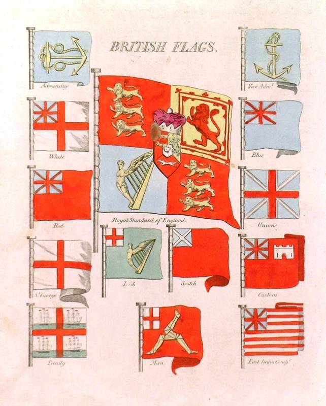
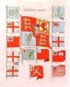
FLAGS & EMBLEMS:64. Anonymous. ‘BRITISH FLAGS’. Flag of the Royal Standard of England surrounded by thirteen other British Flags. Anonymous ca. 1810 [26365] Hand coloured copper engraving, 20 x 20 cm. £80
|
 |
FLAGS & EMBLEMS:67. Anonymous. ‘FLAGS OF ALL NATIONS’. Fifty two different flags headed by the ‘United States’ and ‘Cuba’ flags. On the reverse is a superb collage of ‘THE FLAGS OF THE UNION’ including the original ‘Stars and Stripes’. George F. Cram ca. 1903 [26370] Full colour illustrations on front and verso of one page, 35 x 27 cm. £120
|
 |
GEOGRAPHY / ASTRONOMY:68. Hinton, J. ‘THE FIRST LECTURE IN THE SCIENCES OF GEOGRAPHY AND ASTRONOMY’. Teacher explains globes, spheres and astronomical diagrams to four students. Engraved for the Universal Magazine for J. Hinton 1748 [20111] 19 x 23 cm.
Uncoloured. Excellent condition. £125
|
 |
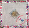
(HAND-) KERCHIEF MAP BOER WAR:68A. Anonymous. ‘THE ABSENT-MINDED BEGGAR’. Map of the South African Republic, the Orange Free State and Natal, printed in blue on large white handkerchief linen, with two portraits (of Lord Roberts and Queen Victoria), music by Arthur Sullivan and a patriotic poem by Rudyard
Kipling. Published by The Daily Mail ca. 1899 [27427] 47 x 47 cm. Excellent condition. £160
Part of an appeal by The Daily Mail, this item was one of a large quantity of merchandise sold to raise money for soldiers fighting in the South African War and their families. The fund was the first charitable effort in Britain for a war. |
 |
|
(HAND-) KERCHIEF MAP EGYPT:68B. Anonymous. ‘EGYPT. SOUVENIR - LONG MAY HE WAVE’. Small map of the Egypt, printed in colours on silk with an embroidered seaman waving a British and a French flag, the borders embellished with various flags and heraldic shields, all printed in
colours. ca. 1900 [27428] 37 x 39 cm. The thin silk material needs flattening, otherwise in very good condition. £200
|
 |
(HAND-) KERCHIEF MAP EUROPE:68C. Anonymous. [CENTRAL EUROPE]. Untitled map, of Central and Eastern Europe (excl. Spain), printed in black on handkerchief type beige linen with brown border. No place, probably UK, ca. 1910 [27429] 33 x 34 cm. Excellent condition. £75
|
 |
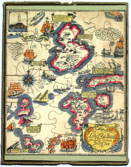
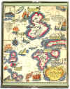
JIGSAW MAP PUZZLE:69. Shurtleff, E. ‘MAP OF THE ISLES OF SHOALS, FORMERLY KNOWN AS SMITHS ILES’. Pictorial jigsaw puzzle map of the Isles of Shoals off the US East coast between Maine and New Hampshire, after a larger map designed and drawn by Elizabeth Shurtleff 1927. In original mailing box with mailing instructions, produced by Jig-Joy Greeting ca. 1930 [26841] 15 x 12 cm. Printed in full
colours. Mailing box slightly worn and lid stained, unused mailing label faded, but the jigsaw map in excellent condition. £150
In addition to historical facts about the isles, the map features poems by Celia
Thaxter. |
 |
|
MILITARY FORTIFICATIONS:74. Steinberger, L. M. ‘TAB. VI. ARCHITECTURA MILITARIS ODER KRIEGS-BAU-KUNST’. Instructive chart showing numerous military instruments of warfare in attack and defence of fortifications. Engraved for Johann Huebner’s Reales
Staats-Zeitungs- und Conversations-Lexicon by Leonhard Michael Steinberger ca. 1782 [24951] 18 x 22 cm.
Uncoloured. Excellent condition. £120
|
 |
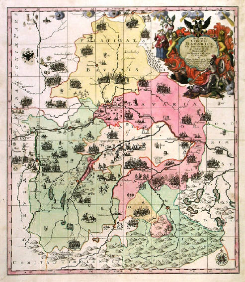
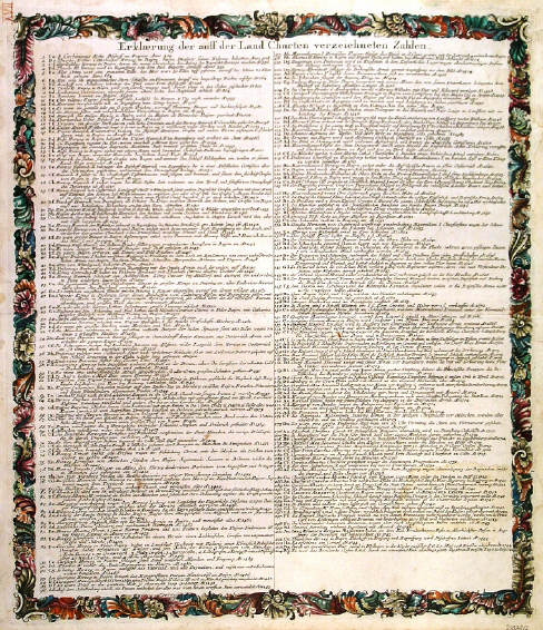
MILITARY HISTORY - BAVARIA:75. Seutter, M. ‘HISTORIA CIRCULI
BAVARICI...’. Antique map of Bavaria in southern Germany, showing over 200 historical and military events from the year 424 up to 1744 with large decorative cartouche and allegorical figures. Separate double sheet with floral surrounds included, listing all events chronologically. Matthaeus Seutter in Augsburg ca. 1750 [23878] 55 x 48 cm and 58 x 49 cm
resp. Full original colour, incl. cartouche. Excellent condition. The set of two sheets £175
|

 |
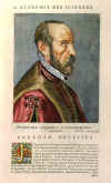
ORTELIUS:78. Bullart, I. ‘ABRAHAM ORTELIUS’. Head and shoulder portrait of Abraham
Ortelius. From Isaac Bullart/Academie des Sciences et des Arts 1682 [22585] 17 x 13 cm, on folio text page with decorative initial J.
Full recent colour. Excellent condition. Ł150 |
 |