|
CHINA:445. Ortelius, A. ‘CHINAE, OLIM SINARUM REGIONIS, NOVA DESCRIPTIO AUCTORE LUDOVICO GEORGIO’. Highly decorative map of China with title cartouche and scale of miles. North orientated to the right. Dated 1584, but published in the Latin text edition by Abraham Ortelius 1592 [25424] 37 x 47 cm. Latin text verso. Very strong, dark printing impression. Superb full original
colour. Excellent condition. £3250
van den Broecke 164. |
 |
CHINA and JAPAN:446. Merian, Matthaeus. ‘CHINA VETERIBUS SINARUM REGIO NUNC INCOLIS TAME DICTA’. Map of China and Japan with large figurative cartouche. Korea is shown as an island. Engraved by Merian and published by Johann Ludwig Gottfried in Frankfurt 1646 [14778] 27 x 34 cm. Excellent condition. £400
Uncoloured as originally published. |
 |
QUINZAY [Hangzhou]:447. Merian, Matthaeus. ‘XUNTIEN ALIAS QUINZAY’. Half birds-eye view of the Chinese city of Quinzay or
Hangchow, one of the eight historic capitals of China. Engraved by Merian and published by Johann Ludwig Gottfried in Frankfurt 1646 [20033] 18 x 26 cm. Excellent condition. £175
Uncoloured as originally published. |
 |
CHINA:448. Janssonius, J. / Schenk, P. & Valk, G. ‘IUNNAN,
QUEICHEU, QUANGSI, ET QUANTUNG ....’. Antique map of the southeast provinces of China, incl. the island of Hainan and the region of Hong Kong and
Macau, with two cartouches, table of explanations and sailing ships. Published by Pieter Schenk and Gerard Valk from the plate by Joannes Janssonius ca. 1700 [22059] 46 x 52 cm. The map in full original
colour. Excellent condition. £450
|
 |
CHINA:449. Janssonius, J. / Schenk, P. & Valk, G. ‘HUQUANG,
KIANGSI, CHEKIANG, AC FOKIEN...’. Antique map of the middle and eastern Chinese provinces between Tropic of Cancer and 35° latitude incl. the area around Shanghai, with northern parts of Formosa just showing. Figurative cartouche, scale of miles and table of explanations. Published by Pieter Schenk and Gerard Valk from the plate by Joannes Janssonius ca. 1700 [22060] 46 x 52 cm. Cartouche, scale of miles and table
uncoloured, the map in full original colour. Short split in centrefold old rebacked. Very good condition. £450
|
 |
|
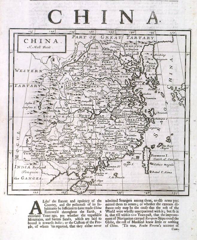
CHINA:450. Moll, H. ‘CHINA’. Map of China. Korea is shown as an island. Hermann Moll ca. 1739 [29673]
17 x 19 cm. Uncoloured copper engraving. £180
|
 |
CHINA and JAPAN:454. Bonne, R. 'CARTE DE L'EMPIRE DE LA CHINE, DE LA TARTARIE
CHINOISE, ET DU ROYAUME DE COREE: AVEC LES ISLES DU JAPON'. Antique map of China, Korea and Japan. Rigobert Bonne ca. 1778 [23553] 32 x 21 cm. Full later
colour. Excellent condition. £150
|
 |
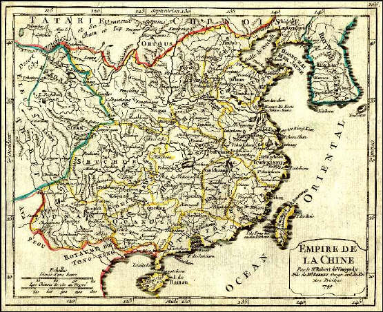
CHINA and KOREA:457. De Vaugondy, R. ‘EMPIRE DE LA CHINE’. China and Korea. Robert de Vaugondy 1749 [18777] 16 x 20 cm. Original outline
colour. Excellent condition. £100
|
 |
CHINA and KOREA:458. Lizars, W. ‘CHINA’. Map of China, Korea and the islands of Hainan and Formosa. William Lizars ca. 1845 [18971] 38 x 45 cm. Original outline
colour. Excellent condition. £120
|
 |
EAST INDIES - MALAYSIA:459. Merian, Matthaeus. ‘INDIA ORIENTALIS ET INSULAE ADIECENTES’. Map of India, Malaysia, East India islands incl. Java, Sumatra, Borneo and Philippines. Engraved by Merian and published by Johann Ludwig Gottfried in Frankfurt 1646 [20075] 27 x 36 cm. Figurative cartouche, many sailing ships. Excellent condition. £400
Uncoloured as originally published. |
 |
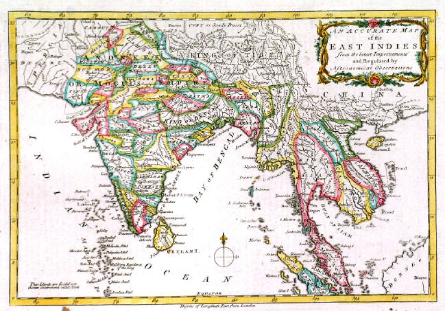
EAST INDIES:463. Anonymous. ‘AN ACCURATE MAP OF THE EAST INDIES FROM THE LATEST IMPROVEMENTS AND REGULATED BY ASTRONOMICAL OBSERVATIONS’. Antique map of India, and East India with pictorial cartouche, probably engraved after Bowen by R. Reynolds ca. 1765 [25636] 20 x 29 cm. Recent outline
colour. Excellent condition. £150
Engraved for Mountague’s History of England. |
 |
HONG KONG:464. Anonymous. ‘HONG KONG RACES, 1876 - A SKETCH IN THE CROWD’. Mixed nationality crowds opposite the grandstand, playing a game of skill and luck. The Graphic 1876 [28966] 30 x 42 cm. Full coloured wood engraving. Excellent condition. £180
|
 |
|
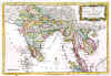
INDIA & EAST INDIA:467. Giraldon. ‘INDE EN DEÇA ET AU DELA DU GANGE’. Antique map of India and East India
(Burmah, Thailand, Malaysia) with pictorial cartouche featuring an elephant. Chamouin after Giraldon ca. 1805 [25806] 22 x 30 cm. Original outline
colour. Some spotting in white top margin outside the image, otherwise very good condition. £80
|
 |
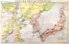
JAPAN and KOREA:474. Schenk, P. & Valk, G. ‘NOVA ET ACCURATA JAPONIAE TERRAE
ESONIS, AC INSULARUM ADJACENTIUM’. Antique map of Japan, Korea (shown as an island) and “Landt van Eso”. Pieter Schenk & Gerard Valk ca. 1700 [22056] 45 x 54 cm. Figurativ cartouche and scale of miles (both
uncoloured), the map in full original colour. Excellent condition. £1250
|
 |
JAPAN and KOREA:475. Bellin, N. ‘CARTE DES ISLES DU JAPON ET LA PRESQU’ISLE DE COREE AVEC LES COSTES DE LA CHINE’. Japan, Korea and the Chinese coast incl. the island of Formosa. Bellin ca. 1750 [17496] 21 x 29 cm. Large cartouche.
Uncoloured. Excellent condition. £180
|
 |
JAPAN and KOREA:479. Philip, G. ‘THE “DAILY MAIL” SPECIAL MAP OF THE FAR EAST’. Antique map of Japan, Korea and parts of eastern China (incl. Shanghai, Peking and
Mukden), with two inset maps of Asia and of the Far East (incl. Philippines, Formosa, Mongolia and Sakhalin). Published by George Philip & Son ca. 1910 [24939] Printed in full
colours. Previously folded, folds flattened. Very good condition. £175
|
 |
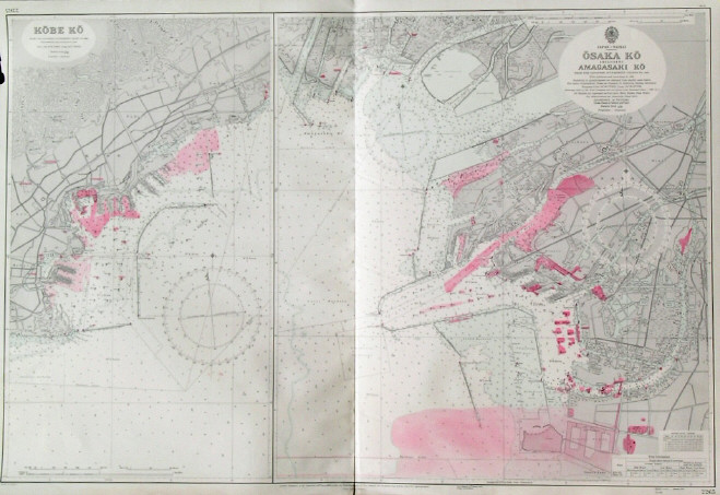
KOBE - OSAKA:481. Admiralty Charts. ‘KOBE KO’ and ‘OSAKA KO INCLUDING AMAGASAKI KO’. Two detailed sea charts of Kobe and Osaka harbours in Japan from Japanese Goernment Charts of 1939 and 1953 respectively. First published at the Admiralty 1955 under the Superintendence of Vice-Admiral Archibald Day, and now with corrections by the Admiralty 1957 [26440] 66 x 99 cm. Uncoloured with red tinted highlights. Excellent condition. £150
|
 |
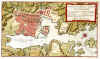
KYOTO:482. Dheulland, G. ‘PLAN DE LA VILLE DE MEACO’. Plan of Kyoto in Japan. Dheulland for Prévost ca. 1750 [17441] 19 x 28 cm.
Full hand colour. Excellent condition. £150
|
 |
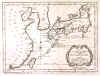
NAGASAKI:484. Bellin, N. 'GRUNDRISS VON DEM HAFEN UND DER STADT
NANGASAKI'. Plan of Nagasaki in Japan and the harbour. Bellin for Prévost ca. 1750 [22898] 19 x 34 cm.
Full hand colour. Excellent condition. £150
|
 |
SUMATRA:489. D’Après de Mannevillette. ‘PLAN DE LA RADE D’ACHEM ET DES ISLES CIRCONVOISINES SITUÉES A LA PARTIE DU NORD-OUEST DE SUMATRA’. Sea chart of the port of Banda Aceh and several adjoining islands on the north tip of Sumatra. G. Delahaye after D’Après de Mannevillette for Neptune Oriental ca. 1775 [19700] 48 x 33 cm. £120
|
 |
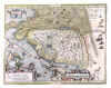
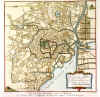
TOKYO:490. Schley, J. v. ‘PLAN DE JEDO’. Plan of Tokyo. Schley for Prévost ca. 1750 [17440] 25 x 25 cm.
Full hand colour. Excellent condition. £150
|
 |
TOKYO:491. Bellin, N. 'GRUNDRISS VON JEDO'. Plan of Tokyo. Bellin for Prévost ca. 1750 [24098] 25 x 25 cm.
Full hand colour. Excellent condition. £150
|
 |
|