|
CARICATURE MAP OF EUROPE:823. Anonymous. ‘COMIC MAP OF EUROPE’. Caricature map of Europe at the beginning of the Franco-Prussian War 1870. Subtitle: ‘England enraged forgets Ireland but still keeps it in her power. Spain & Portugal smoke away lazily. France tries to overthrow Prussia who advances one hand on Holland & knee over Austria. Italy advises Bismark to keep off. Corsica & Sardinia laugh on at all. Denmark hopes to recover Holstein. Turkey is drowsily awaking from smoke. Sweeden (sic!) crouching like a panther. Russia as a begger trying for anything to fill his basket’. Anonymous ca. 1870 [27774] 27 x 38 cm. Full original
colour. Previously folded. Despite some overall light roughness still in very good condition.
£500
Besides being an example of a rare political caricature map, this map is also a document of postal history: It had been originally folded six times into a postcard size shape and posted from
Burnopfield, Co. Durham, to an address in Plymouth on October 24, 1870, where it arrived the next day. It still bears the half penny red stamp which was used. The folds have now been flattened and verso strengthened, almost invisible when viewed from the front. |
 |
|
EUROPE (CONTINENT):824. De Fer, N. ‘L’EUROPE SUIVANT LES NOUVELLES OBSERVATIONS...’. Antique map of the continent of Europe. Nicolas de Fer 1717 [23996] 23 x 33 cm. Two cartouches.
Full hand colour. Excellent condition. £225
|
 |
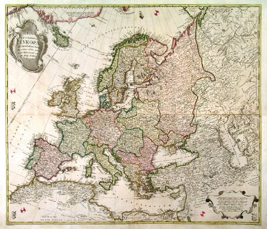
EUROPE (CONTINENT):826. Euler, L. ‘TABULA GEOGRAPHICA EUROPAE AD EMENDATIORA EXEMPLA ADHUC
EDITA...’. Large map of Europe, printed on 4 map sheets and joined. Large title cartouche and smaller cartouche of scale of miles. Leonhard Euler for the Acad. Reg. scient. et litt. eleg. Boruss. (Royal Prussian Academy of Sciences) ca. 1753 [16556] 60 x 69 cm. Full original
colour, the two cartouches uncoloured. Excellent condition. Uncommon. £350
Leonhard Euler (Basel 1707 - St. Petersburg 1783), cartographer, physician and mathematician. Published ‘Atlas Geographicus’ for the Prussian Royal Academy of Sciences and Literature in Berlin between 1753 and 1760. - Small printed original Prussian tax/privilege seal as always. |
 |
EUROPE (CONTINENT):827. Bowen, T. ‘A NEW & ACCURATE MAP OF EUROPE FROM THE LATEST IMPROVEMENTS AND REGULATED BY ASTRONOMICAL OBSERVATIONS’. Antique map of Europe with pictorial cartouche. Thomas Bowen ca. 1765 [25639] 20 x 28 cm. Recent outline
colour. Excellent condition. £125
Engraved for Mountague’s History of England. |
 |
|
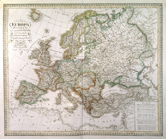
EUROPE (CONTINENT):830. Weiland, C. F. ‘EUROPA...’. Antique map of Europe. Carl Ferdinand Weiland for Verlag des Geograph. Instituts Weimar 1817 [25812] 47 x 56 cm. Original outline
colour. Excellent condition. £150
|
 |
EUROPE (CONTINENT):831. Hall, S. ‘EUROPE’. Sidney Hall 1828 [19265] 41 x 51 cm. Original outline
Colour. £100
|
 |
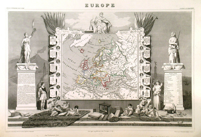
EUROPE (CONTINENT):834. Levasseur, V. ‘EUROPE’. Antique map of Europe with two side borders of heraldic shields, set within very decorative pictorial scenic surround of statues,
putti, allegorical figures and implements. Laguillermie for Levasseur’s Atlas Universel Illustré ca. 1852 [18343] 29 x 44 cm. The map in original outline
colour, the pictorial surrounds uncoloured as issued. Excellent condition. £75
|
 |
EUROPE (CONTINENT):835. Cowperthwait, Desilver & Butler. ‘MAP OF EUROPE COMPILED FROM THE LATEST AUTHORITIES’. Doublepage map of Europe with tables of general statistics down both sides. Drawn by J. H. Young for Cowperthwait, Desilver & Butler in Philadelphia ca. 1854 [26557] 41 x 66 cm. Full original
colour. Excellent condition. £60
|
 |
|
EUROPEAN ATLANTIC ISLANDS:837. Thomson, J. ‘ATLANTIC ISLANDS’. ‘CAPE VERD’ / ‘CANARY’ / ‘AZORE’ / ‘MADEIRA’. Four maps on one sheet, in the centre a view of ‘The Peak of Teneriffe’ from Santa Cruz. Thomson 1814 [19299] 50 x 59 cm. Original outline
colour. Excellent condition. £180
|
 |
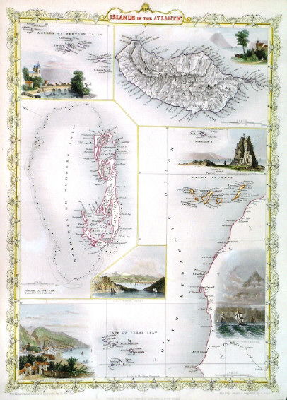
EUROPEAN ATLANTIC ISLANDS:838. Tallis, J. 'ISLANDS IN THE ATLANTIC'. Maps of the Azores, Madeira, Cape Verde, Canary and Bermuda Islands on one sheet, surrounded by decorative border. John Tallis ca. 1851 [26460] 34 x 25 cm. Original outline
colour, all vignettes and border recent colour. Excellent condition. Folio edition - no
centrefold. £90
|
 |
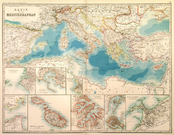
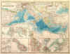
MEDITERRANEAN:839. Johnston, A. K. ‘BASIN OF THE MEDITERRANEAN’. A detailed map, towards the end of the 19th century, with insets of Marseille, Genoa, Trieste, Gibraltar, Maltese Islands, Valletta (Malta), Venice & Alexandria. W. & A. K. Johnston 1892 [25306] Original
colour. 44 x 57 cm. Excellent condition. £125
|
 |
NORTHERN EUROPE - GREENLAND - ICELAND:840. Bellin, N. ‘CARTE REDUITE DES MERS DU NORD’. Antique map of Scandinavia, British Isles, Greenland, Labrador, and Iceland in the
centre. Defined coastlines, but without much inland detail, in the manner of a sea chart. Nicolas Bellin 1758 [21409] 33 x 45 cm. Large cartouche.Full
hand
colour. Excellent condition. £150
|
 |
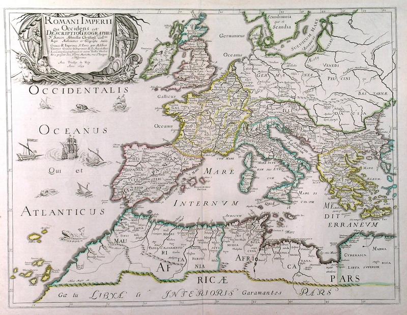
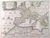
ROMAN EMPIRE:841. Sanson, N. ‘ROMANI IMPERII QUA OCCIDENS EST DESCRIPTIO
GEOGRAPHICA../ ROMANI IMPERII QUA ORIENS EST DESCRIPTIO GEOGRAPHICA...’. Map of the Roman Empire in Europe and Asia Minor, printed on two sheets, not joined. Engraved and printed in Paris by Melchior Tavernier after Nicolas Sanson 1637 [28512] 39 x 52 cm and 39 x 56 cm, or 39 x 86 cm when joined. Original outline
colour, the two cartouches uncoloured. Excellent condition. £375
|
 |