CEYLON:432. Janssonius, J. / P. Schenk et G. Valk. ‘INSULA
ZEILAN, OLIM TAPROBANA, NUNC INCOLIS TENARISIM’. Map of Ceylon with large figurative cartouche and scale of miles, compass roses and sailing ships. Published by Peter Schenk and Gerard Valk after Janssonius ca. 1702 [29742] 41 x 51 cm. North orientated to the left. Full contemporary hand
colour. Excellent. £350
|
 |
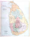
CEYLON:433. Stanford, E. ‘CEYLON’. Large map of Ceylon. Edward Stanford ca, 1894 [24423] 49 x 60 cm. Full original
colour. Excellent condition. £120
|
 |
GOA:434. Merian, Matthaeus. ‘GOA’. Half birds-eye view/plan of Goa in India with table of explanations from 1 - 43, heraldic shield and numerous sailing ship. Engraved by Merian and published by Johann Ludwig Gottfried in Frankfurt 1646 [20060] 27 x 35 cm. Excellent condition. £200
Uncoloured as originally published. |
 |
INDIA:435. Faden, W. ‘A MAP OF THE PENINSULA OF INDIA FROM THE 19TH DEGREE LATITUDE TO CAPE COMORIN’. Large (wall) map of India, printed on two double sheets, not joined, showing the acquisitioins of Great Britain and her Allies by the Partition Treaties in 1792 and 1799. Printed for William Faden 1800 [27782] 99 x 82 cm, when joined. Full original
colour. Excellent condition. £450
|

 |
INDIA:436. Lizars, W. ‘HINDOSTAN’. Map of India with small inset map of Ceylon. William Lizars ca. 1845 [27837] 38 x 49 cm. Original outline
colour. Excellent condition. £80
|
 |
INDIAN OCEAN:437. Tallis, J. 'ISLANDS IN THE INDIAN OCEAN'. Antique map of the Indian Ocean with Madagascar, Mauritius, etc. John Tallis ca. 1851 [26477] 34 x 25 cm. Original outline
colour, all vignettes and border recent colour. Excellent condition. Folio edition - no
centrefold. £90
|
 |