|
624. Mallet, A. M. ‘DIE STADT LONDEN / LONDRES’. View of London from the South with title banner in the sky and figures in the foreground. Alain Manesson Mallet ca. 1719 [24170] 14 x 10 cm.
Full hand colour. Excellent condition. £150 |
 |
|
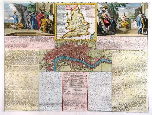
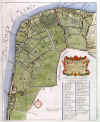
625A. Chatelain, H. A. 'NOUVELLE CARTE DU GOUVERNEMENT CIVIL D'ANGLETERRE ET DE CELUY DE LA VILLE DE
LONDRES'. Small plan of London (PLAN DE LA VILLE DE LONDRES...) surrounded by extensive text, two large allegorical illustrations and a map of England and Wales. Henry Abraham Chatelain ca. 1720 [7799] 35 x 46 cm.
Full hand colour. Excellent condition. £140 Howgego 47. |
 |
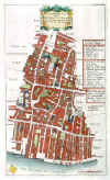
626A. Stow, J. / Strype, J. ‘BREADSTREET WARD AND CORDWAINER WARD...’. Detailed plan with table of references, featuring Watling Street, Bread Street,
Cheapside, Bow Lane, Queen Street. John Strype ca. 1720 [26945] 30 x 18 cm. Full hand
colour. Excellent condition. £90
|
 |
626E. Stow, J. / Strype, J. ‘WALBROOK WARD AND DOWGATE WARD...’. Detailed plan with table of references, featuring Upper Thames Street, Cannon Street,
Walbrook, ‘The Stocks Market’ (= site of Mansion House). John Strype ca. 1720 [28514] 31 x 18 cm. Full hand
colour. Some faint browning, otherwise good condition. £100
|
 |
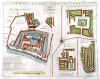
627. Stow, J. / Strype, J. ‘A MAP OF THE TOWER LIBERTY...’. 4 plans on one sheet, showing the Tower, Marine (=
Wellclose) Square, Little Minories, and Spitalfields with Steward, Artillery and Duke Street. John Strype ca. 1720 [28516] 28 x 35 cm.
Uncoloured. Excellent condition. £90
|
 |
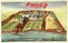
629. Stow, J. / Strype, J. ‘LAMBETH AND CHRIST CHURCH PARISH, SOUTHWARK...’. Detailed plan with table of references, featuring Lambeth Palace, Christ Church, sites of National Theatre, Royal Festival Hall and St. Thomas’ Hospital. John Strype ca. 1720 [28519] 35 x 28 cm. Full hand
colour. Laid down on linen. Excellent condition. £120
|
 |
|
641. Stow, J. / Strype, J. ‘A MAP OF THE TOWER LIBERTY...’. 4 plans on one sheet, showing the Tower, Marine (=
Wellclose) Square, Little Minories, and Spitalfields with Steward, Artillery and Duke Street. John Strype ca. 1720 [26953] 28 x 35 cm.
Full hand colour. Excellent condition. £120 |
 |
|
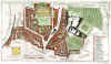
649. Stow, J. / Strype, J. ‘A MAPP OF THE PARISHES OF ST. SAVIOURS SOUTHWARK AND ST. GEORGES...’. Detailed plan with table of references, featuring London Bridge, Southwark Cathedral, St. Thomas Hospital / Guy’s Hospital, Blackmans Street / St. Margarets Hill (= Borough High Street), Gravel / Dirty Lane (= Great Suffolk Street). John Strype ca. 1720 [26961] 29 x 36 cm.
Full hand colour. Excellent condition. £180 |
 |
|
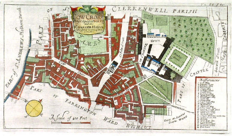
664. Stow, J. / Strype, J. ‘COWCROSS BEING ST. SEPULCHER PARISH AND THE CHARTER HOUSE...’. Detailed plan with table of references, featuring Cowcross Street, St. John Street, Charterhouse. John Strype ca. 1720 [26977] 16 x 30 cm.
Full hand colour. Excellent condition. £100 |
 |
|
665. Stow, J. / Strype, J. ‘QUEEN HITH WARD AND VINTRY WARD...’. Detailed plan with table of references, featuring Upper Thames Street, Queen Street, Vintners Hall, Old Fish Street (= Queen Victoria Street), Garlick Hill. John Strype ca. 1720 [26978] 18 x 30 cm.
Full hand colour. Excellent condition. £100 |
 |
|
666. Stow, J. / Strype, J. ‘WALBROOK WARD AND DOWGATE WARD...’. Detailed plan with table of references, featuring Upper Thames Street, Cannon Street,
Walbrook, ‘The Stocks Market’ (= site of Mansion House). John Strype ca. 1720 [26979] 31 x 18 cm.
Full hand colour. Excellent condition. £90 |
 |
|
676. Stow, J. / Strype, J. ‘THE TEMPLE’. Copper engraving by John Strype ca. 1720 [26989] 20 x 33 cm.
Full hand colour. Excellent condition. £80 |
 |
|
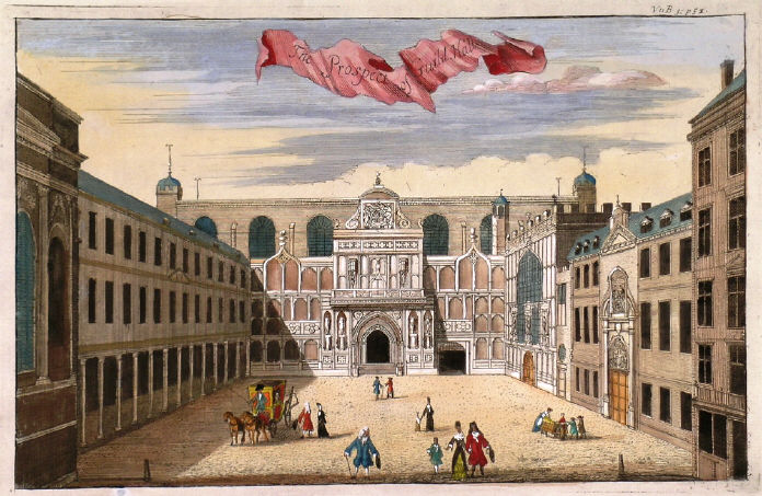
677. Stow, J. / Strype, J. ‘THE PROSPECT OF GUILD HALL’. Copper engraving by John Strype ca. 1720 [26990] 20 x 32 cm.
Full hand colour. Excellent condition. £125 |
 |
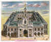
678. Stow, J. / Strype, J. ‘THE HOSPITALL AT GREENWICH’. Half-birds-eye view of the now Royal Navy College and Palace in Greenwich. Copper engraving by John Kip ca. 1720 [26995] 24 x 33 cm. Full hand
colour. Excellent condition. £140
|
 |
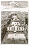
679. Stow, J. / Strype, J. ‘THE ROYALL EXCHANGE OF LONDON’. Half-birds-eye view of the Royal Exchange. Copper engraving by John Strype ca. 1720 [26996] 24 x 29 cm. Full hand
colour. Excellent condition. £120
|
 |
680. Kip, J. ‘CHELSEY COLLEDGE’. Half-birds-eye view of Chelsea Hospital from the North. Copper engraving by John Kip ca. 1720 [26997] 24 x 33 cm. Full hand
colour. Excellent condition. £140
|
 |
|
681. Stow, J. / Strype, J. ‘ST. BARTHOLOMEWS HOSPITALL IN SMITHFIELD’. Copper engraving. John Strype ca. 1720 [27007] 20 x 32 cm.
Uncoloured. Excellent condition. £90 |
 |
|
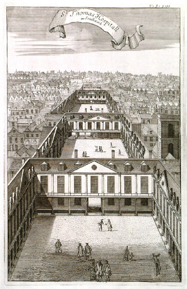
682. Stow, J. / Strype, J. ‘ST THOMAS HOSPITALL IN SOUTHWARK’. Copper engraving. John Strype ca. 1720 [27009] 32 x 20 cm.
Uncoloured. Excellent condition. £90 |
 |
|
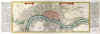
684. Bodenehr, G. ‘LONDEN, WESTMUNSTER U: SOUDWARK’. Plan of London with two title banners in the sky and table of explanations in German to both sides. Extent:
Shoreditch, Stepney, Newington, Hyde Park. Published in ‘Force d’Europe...’ by Gabriel Bodenehr in Augsburg ca. 1725 [28525] 16 x 39 cm (16 x 48 incl. side tables of explanations). Recent hand
colour. Excellent condition. £350
An extended printed key to numerous landmarks and buildings has been pasted to the right (16 x 23 cm). Howgego 57. |
 |
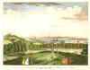
688. Anonymous. ‘VIEW OF LONDON FROM GREENWICH PARK’. Anonymous ca. 1740 [19835] 20 x 30 cm.
Full hand colour. Excellent condition. £120 |
 |
|
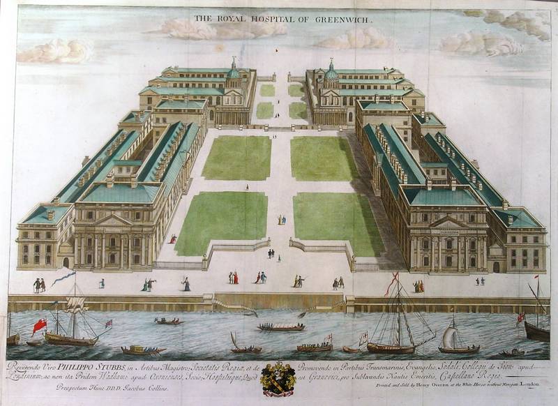
690. Collins, J. / H. Overton. ‘THE ROYAL HOSPITAL OF GREENWICH’. Large half-birds-eye view of the now Royal Navy College and Palace in Greenwich. Copper engraving by Jacobus Collins, printed by Henry Overton ca. 1750 [29873]
48 x 66 cm. Full recent hand
colour. Small area of thinning paper below title, small section on lower left outside image re-margined, otherwise excellent condition. £300 |
 |
|
691. Cole, B. ‘A NEW AND ACCURATE PLAN OF THE CITY OF WESTMINSTER, THE DUTCHY OF LANCASTER AND PLACES ADJACENT’. Plan of Westminster with title cartouche. North orientated to the left. Engraved for Maitland’s Survey of London by Benjamin Cole ca. 1754 [23846] 23 x 36 cm.
Full hand colour. Excellent condition. £125 |
 |
|
692. Anonymous. ‘VIEW OF LONDON FROM ONE-TREE-HILL IN GREENWICH PARK’. London in the distance, Greenwich in the foreground. Printed and engraved for Gentleman’s Magazine January 1754 [25772] 18 x 24 cm.
Full hand colour. Excellent condition. £90 |
 |
|
695. Farington, J. ‘VIEW OF LONDON FROM LAMBETH’. Large double page panoramic view of London from the south, aquatinted by Joseph Constantine Stadler after Joseph
Farington, and published by J. & J. Boydell 1795 [26930] 33 x 55 cm. Uncoloured sepia aquatint engraving. Excellent condition. £350 Abbey
432.
Joseph Farington R.A. (1747-1821), landscape painter, etcher and aquatint engraver of landscapes. - The engraving is dated 1795 in the plate, but in fact from a later re-issue around 1828. |
 |
|
696. Farington, J. ‘VIEW OF LONDON FROM GREENWICH PARK’. Large double
page panoramic view of London from the south, aquatinted by Joseph Constantine Stadler after Joseph
Farington, and published by J. & J. Boydell 1795 [27890] 33 x 55 cm. Uncoloured sepia aquatint engraving. Excellent condition. £350 Abbey
432.
Joseph Farington R.A. (1747-1821), landscape painter, etcher and aquatint engraver of landscapes. - The engraving is dated 1795 in the plate, but in fact from a later re-issue around 1828. |

|
|
698. Farington, J. ‘VIEW OF GREENWICH FROM DEPTFORD YARD’. View of Greenwich across the Thames with sailing ships and boats. Sepia aquatint engraving by Joseph Constantine Stadler after Joseph Farrington, published by J. & J. Boydell 1795 [26998] 21 x 32 cm.
Uncoloured. Excellent condition. £60 Abbey
432.
Joseph Farington R.A. (1747-1821), landscape painter, etcher and aquatint engraver of landscapes. - The engraving is dated 1795 in the plate, but in fact from a later re-issue around 1828. |
 |
|
700. Farington, J. ‘VIEW OF GREENWICH, AND DOWN THE RIVER’. View of Greenwich from the South. Sepia aquatint engraving by Joseph Constantine Stadler after Joseph Farrington, published by J. & J. Boydell 1795 [27000] 21 x 33 cm.
Uncoloured. Excellent condition. £60 Abbey
432.
Joseph Farington R.A. (1747-1821), landscape painter, etcher and aquatint engraver of landscapes. - The engraving is dated 1795 in the plate, but in fact from a later re-issue around 1828. |
 |
|
701. Farington, J. ‘VIEW OF GREENWICH, AND UP THE RIVER’. View of Greenwich from the East towards London. Sepia aquatint engraving by Joseph Constantine Stadler after Joseph Farrington, published by J. & J. Boydell 1795 [27001] 21 x 33 cm.
Uncoloured. Excellent condition. £60 Abbey
432.
Joseph Farington R.A. (1747-1821), landscape painter, etcher and aquatint engraver of landscapes. - The engraving is dated 1795 in the plate, but in fact from a later re-issue around 1828. |
 |
|
702. Farington, J. ‘VIEW OF SOMERSET PLACE, THE ADELPHI, ETC. FROM THE TEMPLE GARDEN’. View of Somerset House and the
Adelphi, with the Thames and boats. Sepia aquatint engraving by Joseph Constantine Stadler after Joseph Farrington, published by J. & J. Boydell 1795 [27002] 21 x 33 cm.
Uncoloured. Excellent condition. £60 Abbey
432.
Joseph Farington R.A. (1747-1821), landscape painter, etcher and aquatint engraver of landscapes. - The engraving is dated 1795 in the plate, but in fact from a later re-issue around 1828. |
 |
|
703. Farington, J. ‘LONDON BRIDGE’. View of London Bridge from the Southwest towards the Monument. Sepia aquatint engraving by Joseph Constantine Stadler after Joseph Farrington, published by J. & J. Boydell 1795 [27003] 21 x 33 cm.
Uncoloured. Excellent condition. £80 Abbey
432.
Joseph Farington R.A. (1747-1821), landscape painter, etcher and aquatint engraver of landscapes. - The engraving is dated 1795 in the plate, but in fact from a later re-issue around 1828. |
 |
|
704. Farington, J. ‘VIEW OF LAMBETH FROM MILLBANK’. View of Lambeth Palace across the Thames. Sepia aquatint engraving by Joseph Constantine Stadler after Joseph Farrington, published by J. & J. Boydell 1795 [27004] 21 x 33 cm.
Uncoloured. Excellent condition. £60 Abbey
432.
Joseph Farington R.A. (1747-1821), landscape painter, etcher and aquatint engraver of landscapes. - The engraving is dated 1795 in the plate, but in fact from a later re-issue around 1828. |
 |