| 708. Turner, Ch. ĹJAMES THE FIRST, KING OF GREAT BRITAINĺ. Full length portrait of James I on a prancing horse, with view of London, Southwark and London Bridge behind. Mezzotint engraving after Delaram. Charles Turner ca. 1810 [19053] 32áxá23ácm. Uncoloured. Excellent condition. £120 |
 |
|
712. Walker, J. & C. / Lewis, S. 'A PLAN OF LONDON AND ITS ENVIRONS'. Plan of London with Arms of Westminster, London and Southwark set in top border. Extent: Hyde Park, Regents Park, Victoria Park,
Peckham. Engraved by J. & C. Walker after R. Creighton for Lewis's Topographical Dictionary 1834 [29674] |
 |
| 713. Anonymous. ĹGUIDE FOR EXCURSIONS ON THE RIVER THAMES, FROM ETON TO THE NOREĺ. Strip panorama of the Thames in three vertical parts from Eton to Rochester, the central part dedicated to London. Wood engraving 1849 [24706]
52áxá37ácm. Full hand colour. Excellent condition. £450 |
 |
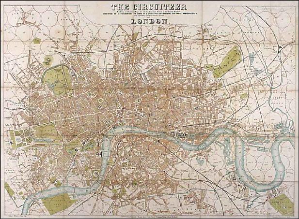
| 715. Friederichs, J. ĹTHE CIRCUITEERĺ. Unusual folding Ĺdistance mapĺ of London Ĺto serve as a guide for ascertaining cab fares, porterage & &. With explanations in English, French & Germanĺ. The map is covered with circles 4ácm in diameter (to represent half a mile each). With small 32-page booklet of explanations and abstracts of laws, and a list of principal streets and squares. Lithographed by D. Levy Elkan in Cöln and published by Joachim Friederichs ca. 1851 [21004] 50áxá69ácm. Printed in colours. Previously folded, all folds flattened, rather worn and folds browned. Uncommon. £450 |
 |
| 716. Dower, J. ĹENVIRONS OF LONDONĺ - WINDSOR CASTLE TO GRAVESENDĺ. Plan of the environs of London with small vignette views of important and interesting places. Designed, drawn and engraved by John Dower for Illustrated London News ca. 1851 [23587] 51 x 77 cm. Previously folded. Full colour. Excellent condition. £150 |
 |
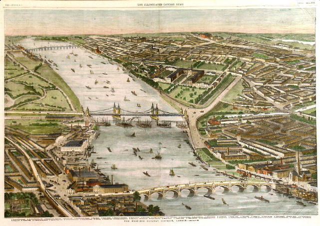
| 718. Anonymous. ĹTHE WEST-END RAILWAY DISTRICT, LONDONĺ. Half birds-eye view of the Westend of London with the Thames and Vauxhall Bridge and Victoria Bridge in the centre, Battersea Park to Vauxhall Gardens on the South Bank, and the area from Chelsea to Pimlico via Kings Road and Cheyne Walk, reaching to the Oratory and Hyde Park, on the North Bank. Woodengraving 1859 [24701] 36áxá52ácm. Full hand colour. Excellent condition. £180 |
 |
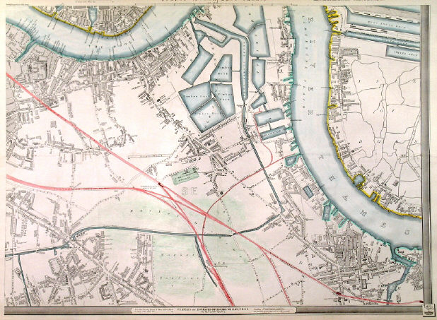
| 724. Weller, E. ĹISLE OF DOGS, DEPTFORD, POOL OF LONDONĺ. South-eastern sheet of the large nine sheet MAP OF LONDON. Scale: 9áinches to the mile. Extent: Wapping Basin, West India Dock (Isle of Dogs), Peckham New Town. South Eastern Railway indicated. Edward Weller ca. 1861 [25954] 45 x 63 cm. Recent outline colour. Excellent condition. £150 |
 |
725. Anonymous. ĹAN ARCHITECTURAL GROUP IN WESTMINSTERĺ. Image of Westminster Abbey, with the Houses of Parliament and Elizabeth Tower (Big Ben) in the background. Illustrated London News 1862 [29874] |
 |
728. Wyld, J. ĹWYLDĺS NEW PLAN OF LONDON FOR 1864ĺ. Folding map of London, dissected into 24 segments and laid down on linen. Extent: Kilburn,
Highgate, Isle of Dogs, Camberwell. James Wyld 1864 [30017] 58áxá73ácm. Original outline
colour. Map in excellent condition. £750 |
 |
|
729. Anonymous. ĹNORTH BANK OF THE THAMES, FROM THE PALACE OF WESTMINSTER TO LONDON BRIDGE...ĺ. Panorama in two parts arranged above each other, showing the Embankment in course of construction, with lively boat and ship scenes on the Thames and St. Paulĺs in the background. Wood engraving 1865 [24703] 33áxá52ácm. Full hand colour. Excellent condition. £100 |
 |
730. Anonymous. ĹGOLFĺ. Five scenes on one page in the grounds of the
Royal Blackheath Golf Club, set within a decorative border: Striking from the Tee / A Bunker / The Putting Green / A Stimy / The Fore Caddie. The first Ĺgolfĺ print issued with Volume I of The Graphic 1869 [30996]
30 x 23 cm. Genuine antique wood engraving. Full recent hand colour. Excellent condition. £225 |
 |
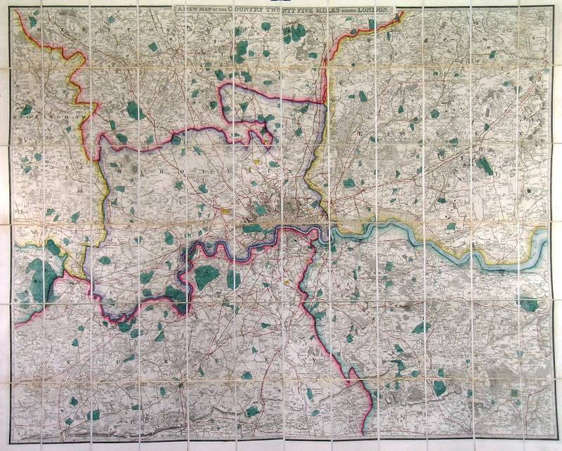
| 731. Wyld, J. ĹA NEW MAP OF THE COUNTRY TWENTY-FIVE MILES ROUND LONDONĺ. Folding map of London and its environs, extending to
Amersham, Hertford and Chelmsford in the north, and to Guildford, Reigate and Tonbridge in the south, dissected into 72ásegments and laid down on linen. James Wyld ca. 1870 [15807] 103áxá128ácm. Original outline
colour. £450 Hyde/App. I/188. |
 |
|
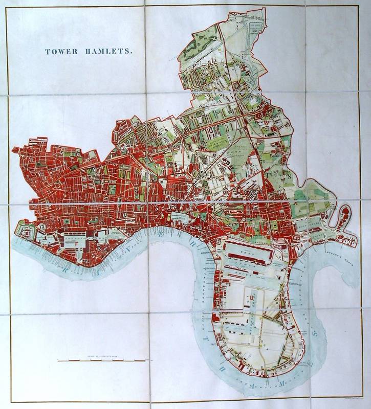
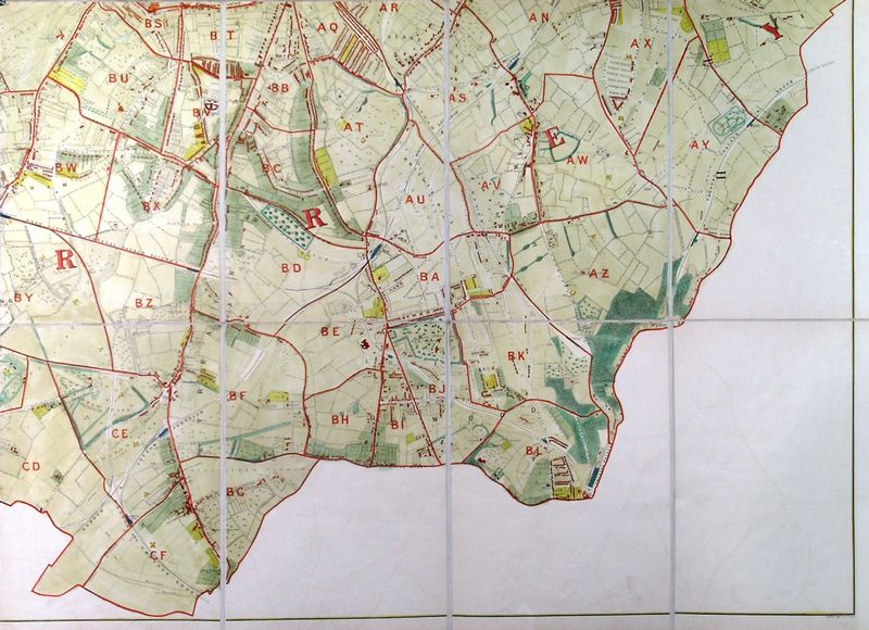
732A. Stanford, E. ĹTOWER HAMLETSĺ. Large and highly detailed folding map, dissected into 12 segments and laid down on linen. Reaching far beyond Tower Hamlets from Whitechapel and Wapping via Limehouse to Bow, the Isle of Dogs and Canary Wharf. Edward Stanfordĺs Geographical Establishment ca. 1875 [28528] 67áxá60ácm. Full hand
colour. Excellent condition. Six inches to a mile. £650 |
 |
|
732B. Stanford, E. ĹSOUTHWARKĺ. Highly detailed folding map, dissected into 4 segments and laid down on linen. Reaching on the southside of the Thames from Blackfriars Bridge via Bermondsey to
Rotherhithe. Edward Stanfordĺs Geographical Establishment ca. 1875 [28529] 29áxá52ácm. Full hand colour. Excellent condition. Six inches to a mile. £280 |
 |
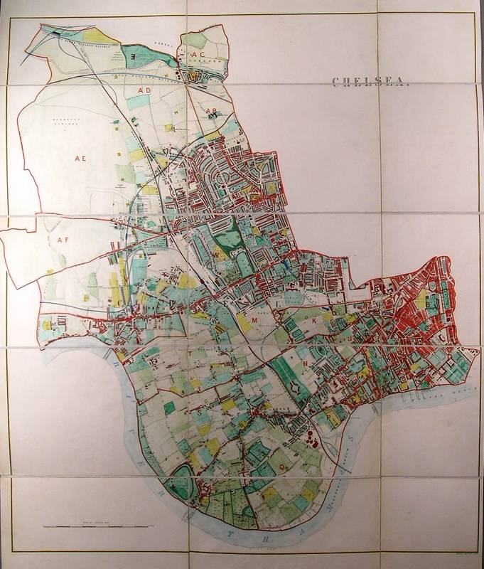
| 732C. Stanford, E. ĹCHELSEAĺ. Large and highly detailed folding map, dissected into 12 segments and laid down on linen. Covering the whole
West London area north of the Thames between Sloane Street,
Fulham, Hammersmith, Brompton, Kensington, Notting Hill and Kensal Green. Edward Stanfordĺs Geographical Establishment ca. 1875 [28530] 66áxá67ácm. Full hand
colour. Excellent condition. Six inches to a mile. £1950 Hyde 168. |
 |
|
732G. Stanford, E. ĹCITY OF LONDONĺ. Small folding map of the City of London, dissected into 2 segments and laid down on linen. Edward Stanfordĺs Geographical Establishment ca. 1875 [28532] 18áxá29ácm.
Full hand colour. Excellent condition. Six inches to a mile. £250 |
 |
|
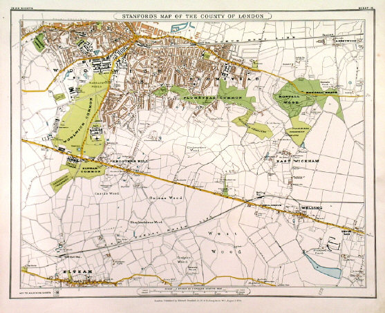
732L. Stanford, E. ĹGREENWICHĺ. Very large and highly detailed folding (wall) map, dissected into 32 segments and laid down on linen. Covering Greenwich, Woolwich,
Plumstead, reaching South to Sydenham, Southend and Eltham. Blackheath in the
centre. Edward Stanfordĺs Geographical Establishment ca. 1875 [28538] 104áxá145ácm. Full hand colour. Excellent condition. £850 |
  |
|
Howgego 168. |
    |
| 735. Stanford, E. ĹSTANFORDĺS MAP OF THE BRITISH METROPOLIS AND SUBURBSĺ. Folding map of London, dissected into 28 segments and laid down on linen, folding into original boards. Extent: Hammersmith - Holloway - West India Docks - Dulwich (radius of 4ámiles from Charing Cross). Published by Letts, Son & Co. 1880 [29434] 66áxá79ácm. Original
colour. Excellent condition. £850 |
 |
| 737. Smith & Son, W. H. ĹENVIRONS OF LONDONĺ. Folding map of London and its environs, not dissected. Extent: Windsor, Potters Bar, Barking, Epsom. W. H. Smith & Son ca. 1880 [26222] 71áxá84ácm, folding into original boards. Full original colour. Excellent condition. £250 |
 |
738. Braun, G. / Hogenberg, F. / London Topographical Society. ĹLONDINUM FERACISSIMI ANGLIAE REGNI METROPOLISĺ. Birds-eye plan of London with decorative title cartouche, two large coats of arms, two tables of explanations, and four figures in the foreground. Early
re-etching of the famous Braun & Hogenberg plan, engraved by The Typographic Etching Company and published by London Topographical Society 1882- 1883 [28374] 33áxá49ácm. Full recent hand
colour. Excellent condition. £500 |
 |
739. Read, S. ĹST. PAULĺS CATHEDRAL, LONDONĺ. View of the Cathedral with numerous people and carriages in the front. For the Illustrated London News drawn by S. Read 1883 [25909] |
 |
740. Braun, G. / Hogenberg, F. / Topographical Society of London. ĹLONDINUM FERACISSIMI ANGLIAE REGNI METROPOLISĺ. Birds-eye plan of London with decorative title cartouche, two large coats of arms, two tables of explanations, and four figures in the foreground. 19th century re-etching of the famous Braun & Hogenberg plan, engraved by the Typographic Etching Society and published by The London Topographical Society 1882- 1883 [29745] |
 |
| 741. Letts, Son & Co. ĹGEOLOGICAL MAP OF THE ENVIRONS OF LONDONĺ. Scale: 3/4 Inch to the Mile. Extent: Southgate, Barking, Norwood, Hanwell. Lettsĺs Popular Atlas ca. 1884 [25593] 31áxá39ácm. Printed in colours. Excellent condition. £80 |
 |
| 742. Letts, Son & Co. ĹLONDON (WEST)ĺ and ĹLONDON (EAST)ĺ. Two interesting plans of London, laid on linen, not joined, showing the high water marks in feet above Trinity. Extent: Islington, Isle of Dogs, Camberwell, Kensington Gardens. Lettsĺs Popular Atlas ca. 1884 [25597] 39áxá66ácm when joined. Printed in colours. Excellent condition. £90 |
 |
|
743. Overend, W. H. ĹTHE TOWER BRIDGE, TO BE ERECTED OVER THE THAMES: ...ĺ. Lively artistĺs impression of Tower Bridge with barges and steamship passing. For the Illustrated London News drawn by the Marine painter William Heysham Overend 1886 [24702] |
 |
| 747. Bacon, G. W. [CENTRAL LONDON. Extent: HYDE PARK, REGENTS PARK, SHOREDITCH, TOWER, LAMBETH PALACE]. Detailed map from Baconĺs ĹNew Large-scale Atlas of London and Suburbsĺ. G. W. Bacon 1886 [26454] 31áxá49ácm. Original colour. Excellent condition. £120 4-inch scale. |
 |
748. Brewer, H. W. ĹTHE ROYAL ROUTE FROM BUCKINGHAM PALACE TO WESTMINSTER ABBEY ON JUBILEE DAY JUNE 21ĺ. A superb birdĺs-eye view of Westminster, Green Park, Pall Mall, Buckingham Palace and Piccadilly. The Graphic 1887 [29875] |
 |
|
749. Bacon, G. W. ĹBACONĺS NEW MAP OF LONDON DIVIDED INTO HALF MILE SQUARES & CIRCLESĺ. Antique map of Central London. Extent: Holland Park, Hampstead, West India Docks, Brixton. G. W. Bacon ca. 1888 [27700] 65áxá82ácm. Previously folded. Original outline
colour. Very good condition. £250 |
 |
750. Williamson. 'A BOOK-SALE AT SOTHEBYĺS AUCTION-ROOMĺ. Book sale at Sothebyĺs London, auctioneer Mr. Hodge. Attended by around 14 named London bookdealers, Quaritch, Reeves, Walford, Molini, etc. Wood engraving by Williamson for The Graphic 1888 [25442] 31áxá45ácm. Full hand colour. Excellent condition. £225 |
 |
| 757. Stanford, E. ĹCENTRAL LONDON, SOUTH EASTĺ. The South East part of Central London. Extent: Vauxhall, St Katherine Docks, Limehouse Reach and Peckham Rye. Edward Stanford ca. 1894 [23111] 33áxá48 cm. Full original colour. Excellent condition. £150 |
 |
| 758. Stanford, E. ĹCENTRAL LONDON, NORTH EASTĺ. The North East part of Central London. Extent: Victoria Park, Limehouse, Tower Bridge, Charing Cross, Kings Cross, Islington, The City. Edward Stanford ca. 1894 [23112] 33áxá48 cm. Full original colour. Excellent condition. £150 |
 |
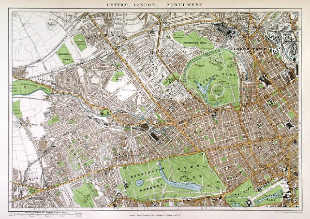
| 759. Stanford, E. ĹCENTRAL LONDON, NORTH WESTĺ The North West part of Central London. Extent: Shepherds Bush, Primrose Hill, Bloomsbury, Kensington Gardens/Hyde Park. Edward Stanford ca. 1894 [23952] 33áxá48 cm. Printed in full colour. Excellent condition. £250 |
 |
| 761. Bartholomew, J. ĹLONDONĺ. Antique map of Central London. Extent: Hyde Park, St Catherineĺs Dock, Vauxhall and Kings Cross. John Bartholomew ca. 1896 [25608] 32áxá42ácm. Full original colour. Excellent condition. £80 |
 |
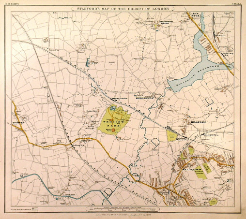
| 764. Stanford, E. (WEMBLEY, KINGSBURY, NEASDEN, WILLESDEN). Stanfordĺs map of the County of London. Sheet 1, Willesden, Hendon, The Hyde, Neasden, Wembley Park, Sudbury. Edward Stanford 1894 - 1901 [23094] 37 x 42 cm. Full original colour. Excellent condition. £100 |
 |
| 766. Stanford, E. (HACKNEY, WANSTEAD, EPPING, WEST HAM & FOREST GATE). Stanfordĺs map of the County of London. Sheet 4, Epping Forest, Hackney Marsh, Wanstead Flats, Stratford. Edward Stanford 1894 - 1901 [23097] 37 x 42 cm. Full original colour. Excellent condition. £100 |
 |
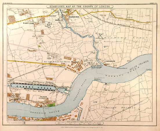
| 768. Stanford, E. (EAST HAM, BARKING, WOOLWICH, LONDON CITY AIRPORT, SITE OF OLYMPICS 2012). Stanfordĺs map of the county of London, Sheet 10. East Ham, Barking, Creekmouth, North Woolwich, the site of London City Airport and the Olympics 2012. Edward Stanford 1894 - 1901 [23100] 37áxá42ácm. Full original colour. Excellent condition. £100 |
 |
| 769. Stanford, E. (KENNINGTON, STOCKWELL, DULWICH & PECKHAM). Stanfordĺs map of the County of London. Sheet 13, Kennington, Stockwell, Dulwich, Peckham. Edward Stanford 1894 - 1901 [23103] 37 x 42 cm. Full original colour. Excellent condition. £120 |
 |
| 770. Stanford, E. (WOOLWICH, SHOOTERS HILL & PLUMSTEAD). Stanfordĺs map of the County of London. Sheet 15, Woolwich Common, Eltham, Plumstead, Welling. Edward Stanford 1894 - 1901 [23105] 37 x 42 cm. Full original colour. Excellent condition. £100 |
 |
| 772. Stanford, E. (SYDENHAM, BECKENHAM & BROMLEY). Stanfordĺs map of the County of London, Sheet 19 C. Edward Stanford 1894 - 1901 [23109] 37 x 42 cm. Full original colour. Excellent condition. £100 |
 |
773. Baker, Chas. ĹLONDON IN THE BEGINNING OF THE 20TH CENTURYĺ or ĹTHE PICTORIAL PLAN OF LONDONĺ. Large plan/birds-eye Millenium view of London in ornamental border, previously folded. Extent: Regents Park, London Docks, The Oval, Kensington Palace. Includes new section covering parts of the Fulham Road and Chelsea. Charles Baker & Co. ca. 1901 [26018]
42áxá78ácm. Printed in full original colour. Folds nicely flattened out and strengthened. Very good condition. £375 |
 |
| 777. Stanford, E. ĹSTANFORDĺS NEW MAP OF THE COUNTY OF LONDONĺ, here: [BARKING - WOOLWICH - ELTHAM - SIDCUP - CHISLEHURST]. Folding map of East London, reaching from Barking down to Woolwich with the (now) City Airport, Eltham, Sidcup and Chislehurst, being a large vertical part of Stanfordĺs monumental ĹNew Antique map of the County of London on the scale of four inches to one mileĺ. Dissected into 18 segments and laid down on linen. Edward Stanford ca. 1905 [25426] 97áxá40ácm, excluding large title box above. Original outline colour. Excellent condition. £120 |
  |
| 778. Philip, G. ĹPHILIPSĺ NEW MAP OF CENTRAL LONDONĺ. Antique map of London, printed on thin linen/silk. Extent: Kentish Town, London Docks, South Lambeth, Notting Hill. George Philip & Son ca. 1905 [25958] 40áxá56ácm, folding into original slipcase (12áxá9ácm). Uncoloured. Excellent condition. Uncommon. £120 Accompanied by 16-page booklet entitled ĹMiniature Guide to Londonĺ. |
 |
| 779A. Bacon, G. W. [FULHAM, PARSONS GREEN, WANDSWORTH, PUTNEY]. Detailed map from Baconĺs ĹNew Large-scale Atlas of London and Suburbsĺ. G. W. Bacon 1907 [26273] 30áxá48ácm. Original
colour. Excellent condition. £150 These 9-inch large scale Bacon maps are rarely offered for sale, showing smaller areas in much greater detail than the common 4-inch scale maps. |
 |
|
779H Bacon, G. W. [HOUNSLOW, SPRING GROVE, BRENTFORD, KEW, EAST SHEEN, RICHMOND,
ISLEWORTH]. Detailed map from Baconĺs ĹNew Large-scale Atlas of London and Suburbsĺ. G. W. Bacon 1908 [26247] 31áxá49ácm. Original
colour. Excellent condition. £60 |
 |
|
779J. Bacon, G. W. [KENSAL GREEN, KENSAL NEW TOWN, NORTH KENSINGTON, ST. QUINTIN PARK]. Detailed map from Baconĺs ĹNew Large-scale Atlas of London and Suburbsĺ. G. W. Bacon 1908 [26270] 30áxá48ácm. Original
colour. Excellent condition. £120 |
 |
|
779K. Bacon, G. W. [CHELSEA, BATTERSEA PARK, WALWORTH, CAMBERWELL, EAST
DULWICH, HERNE HILL, BRIXTON, CLAPHAM]. Detailed map from Baconĺs ĹNew Large-scale Atlas of London and Suburbsĺ. G. W. Bacon 1908 [26278] 31áxá49ácm. Original
colour. Excellent condition. £150 |
 |
|
779L. Bacon, G. W. [DARTMOUTH PARK, KENTISH TOWN, HAVERSTOCK HILL, PRIMROSE HILL, CAMDEN]. Detailed map from Baconĺs ĹNew Large-scale Atlas of London and Suburbsĺ. G. W. Bacon 1908 [26280] 46áxá32ácm. Original
colour. Excellent condition. 150 |
 |
| 780. Bacon, G. W. [HENDON, CHURCH END, FINCHLEY, WOODSIDE PARK, EAST END, MILL HILL]. Detailed map from Baconĺs ĹNew Large-scale Atlas of London and Suburbsĺ. G. W. Bacon 1908 [26234] 31áxá49ácm. Original colour. Excellent condition. £60 4-inch scale. |
 |
| 781. Bacon, G. W. [KINGSBURY, WILLESDEN, CRICKLEWOOD, GOLDERS GREEN, CHILDS HILL, HAMPSTEAD]. Detailed map from Baconĺs ĹNew Large-scale Atlas of London and Suburbsĺ. G. W. Bacon 1908 [26238] 31áxá49ácm. Original colour. Excellent condition. £80 4-inch scale. |
 |
| 782. Bacon, G. W. [HIGHGATE, FINSBURY PARK, HIGHBURY, CANONBURY, HOLLOWAY, KENTISH TOWN, HAMPSTEAD HEATH]. Detailed map from Baconĺs ĹNew Large-scale Atlas of London and Suburbsĺ. G. W. Bacon 1908 [26239] 31áxá49ácm. Original colour. Excellent condition. £80 4-inch scale. |
 |
| 787. Bacon, G. W. [PLAISTOW, BARKING, NORTH WOOLWICH, CITY AIRPORT]. Detailed map from Baconĺs ĹNew Large-scale Atlas of London and Suburbsĺ. G. W. Bacon 1908 [26246] 31áxá49ácm. Original colour. Excellent condition. £120 4-inch scale. |  |
| 788. Bacon, G. W. [HOUNSLOW, SPRING GROVE, BRENTFORD, KEW, EAST SHEEN, RICHMOND, ISLEWORTH]. Detailed map from Baconĺs ĹNew Large-scale Atlas of London and Suburbsĺ. G. W. Bacon 1908 [26247] 31áxá49ácm. Original colour. Excellent condition. £120 4-inch scale. |
|
| 790. Bacon, G. W. [PECKHAM, DEPTFORD, GREENWICH, BLACKHEATH, LEWISHAM, BROCKLEY, EAST DULWICH]. Detailed map from Baconĺs ĹNew Large-scale Atlas of London and Suburbsĺ. G. W. Bacon 1908 [26249] 31áxá49ácm. Original colour. Excellent condition. £120 4-inch scale. |
 |
| 791. Bacon, G. W. [TWICKENHAM, PETERSHAM, RICHMOND PARK, NORBITON, HAMPTON WICK, BUSHY PARK, TEDDINGTON, NEW HAMPTON]. Detailed map from Baconĺs ĹNew Large-scale Atlas of London and Suburbsĺ. G. W. Bacon 1908 [26251] 31áxá49ácm. Original colour. Excellent condition. £120 4-inch scale. |
 |
| 793. Bacon, G. W. [HAMPSTEAD HEATH, NORTH END, KENWOOD, HIGHGATE, NORTH HILL]. Detailed map from Baconĺs ĹNew Large-scale Atlas of London and Suburbsĺ. G. W. Bacon 1908 [26263] 30áxá48ácm. Original colour. Excellent condition. £120 These 9-inch large scale Bacon maps are rarely offered for sale, showing smaller areas in much greater detail than the common 4-inch scale maps. |
 |
| 797. Bacon, G. W. [WANDSWORTH BRIDGE ROAD, BATTERSEA, CLAPHAM JUNCTION, LAVENDER HILL]. Detailed map from Baconĺs ĹNew Large-scale Atlas of London and Suburbsĺ. G. W. Bacon 1908 [26274] 30áxá48ácm. Original colour. Excellent condition. £120 These 9-inch large scale Bacon maps are rarely offered for sale, showing smaller areas in much greater detail than the common 4-inch scale maps. |
 |
| 798. Bacon, G. W. [WANDSWORTH, CLAPHAM, STOCKWELL, BRIXTON]. Detailed map from Baconĺs ĹNew Large-scale Atlas of London and Suburbsĺ. G. W. Bacon 1908 [26275] 30áxá48ácm. Original colour. Excellent condition. £90 These 9-inch large scale Bacon maps are rarely offered for sale, showing smaller areas in much greater detail than the common 4-inch scale maps. |
 |
| 800. Bacon, G. W. [NEW PECKHAM, NEW CROSS, DEPTFORD NEW TOWN, BROCKLEY, NUNHEAD]. Detailed map from Baconĺs ĹNew Large-scale Atlas of London and Suburbsĺ. G. W. Bacon 1908 [26277] 30áxá48ácm. Original colour. Excellent condition. £80 These 9-inch large scale Bacon maps are rarely offered for sale, showing smaller areas in much greater detail than the common 4-inch scale maps. |
 |
| 802. Bacon, G. W. [HAMPSTEAD, FINCHLEY, WEST END, KILBURN, ST. JOHNS WOOD]. Detailed map from Baconĺs ĹNew Large-scale Atlas of London and Suburbsĺ. G. W. Bacon 1908 [26279] 46áxá32ácm. Original colour. Excellent condition. £120 These 9-inch large scale Bacon maps are rarely offered for sale, showing smaller areas in much greater detail than the common 4-inch scale maps. |
 |
| 804. Bacon, G. W. [TUFNELL PARK, UPPER and LOWER HOLLOWAY, BARNSBURY, CAMDEN TOWN] . Detailed map from Baconĺs ĹNew Large-scale Atlas of London and Suburbsĺ. G. W. Bacon 1908 [26281] 46áxá32ácm. Original colour. Excellent condition. £90 These 9-inch large scale Bacon maps are rarely offered for sale, showing smaller areas in much greater detail than the common 4-inch scale maps. |
 |
| 807. Bacon, G. W. [HACKNEY MARSHES, HACKNEY WICK, VICTORIA PARK, OLDFORD] . Detailed map from Baconĺs ĹNew Large-scale Atlas of London and Suburbsĺ. G. W. Bacon 1908 [26284] 46áxá32ácm. Original colour. Excellent condition. £90 These 9-inch large scale Bacon maps are rarely offered for sale, showing smaller areas in much greater detail than the common 4-inch scale maps. |
 |
| 808. Bacon, G. W. [LEYTON, STRATFORD, WEST HAM, Site of LONDON OLYMPICS 2012] . Detailed map from Baconĺs ĹNew Large-scale Atlas of London and Suburbsĺ. G. W. Bacon 1908 [26286] 46áxá32ácm. Original colour. Excellent condition. £90 These 9-inch large scale Bacon maps are rarely offered for sale, showing smaller areas in much greater detail than the common 4-inch scale maps. |
 |
| 809. Bacon, G. W. [KILBURN, WESTBOURNE PARK, PADDINGTON, BAYSWATER] . Detailed map from Baconĺs ĹNew Large-scale Atlas of London and Suburbsĺ. G. W. Bacon 1908 [26287] 46áxá32ácm. Original colour. Excellent condition. £150 These 9-inch large scale Bacon maps are rarely offered for sale, showing smaller areas in much greater detail than the common 4-inch scale maps. |
 |
| 811. Bacon, G. W. [SHOREDITCH, FINSBURY, THE CITY] . Detailed map from Baconĺs ĹNew Large-scale Atlas of London and Suburbsĺ. G. W. Bacon 1908 [26290] 46áxá32ácm. Original colour. Excellent condition. £150 These 9-inch large scale Bacon maps are rarely offered for sale, showing smaller areas in much greater detail than the common 4-inch scale maps. |
 |
| 813. Bacon, G. W. [MILE END, BOW, TOWER HAMLETS, LIMEHOUSE, POPLAR] . Detailed map from Baconĺs ĹNew Large-scale Atlas of London and Suburbsĺ. G. W. Bacon 1908 [26292] 46áxá32ácm. Original colour. Excellent condition. £90 These 9-inch large scale Bacon maps are rarely offered for sale, showing smaller areas in much greater detail than the common 4-inch scale maps. |
 |
| 816. Bacon, G. W. [WESTMINSTER, LAMBETH, KENNINGTON] . Detailed map from Baconĺs ĹNew Large-scale Atlas of London and Suburbsĺ. G. W. Bacon 1908 [26296] 46áxá32ácm. Original colour. Excellent condition. £150 These 9-inch large scale Bacon maps are rarely offered for sale, showing smaller areas in much greater detail than the common 4-inch scale maps. |
 |
|
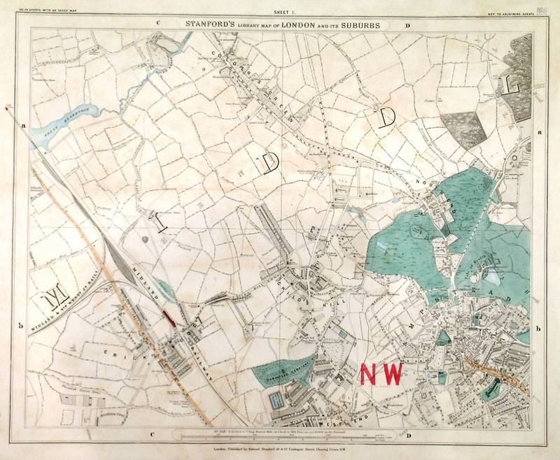
819. Stanford, E. ĹSTANFORDĺS LIBRARY MAP OF LONDON AND ITĺS SUBURBSĺ - ( Sheet 1).
Cricklewood, Golderĺs Green, Northend, Childs Hill, Hampstead. Edward Stanford c. 1890 [27461] 33 x 41 cm. Original coloured plan. £120 |
 |
|
821. Stanford, E. ĹSTANFORDĺS LIBRARY MAP OF LONDON AND ITĺS SUBURBSĺ - ( Sheet 4).
Walthamstow, Leyton, Lea Bridge Road. Edward Stanford c. 1890 [27464] 33 x 41 cm. Original coloured plan. £100 |
 |
|
822. Stanford, E. ĹSTANFORDĺS LIBRARY MAP OF LONDON AND ITĺS SUBURBSĺ - ( Sheet 5). Kensal Green,
Willesden, Kilburn, St Johnĺs Wood, Paddington. Edward Stanford c. 1890 [27465] 33 x 41 cm. Original coloured plan. £150 |
 |
|
824. Stanford, E. ĹSTANFORDĺS LIBRARY MAP OF LONDON AND ITĺS SUBURBSĺ - ( Sheet 7).
Clerkenwell, Islington, Canonbury, Dalston, Hackney, Bethnal Green,
Hoxton. Edward Stanford c. 1890 [27467] 33 x 41 cm. Original coloured plan. £150 |
 |
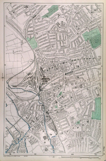
| 825. Stanford, E. ĹSTANFORDĺS LIBRARY MAP OF LONDON AND ITĺS SUBURBSĺ - ( Sheet 8). Old Ford, Victoria Park, Hackney Wick, Wanstead, Stratford New Town, West Ham, Bow. Site of 2012 Olympic Games. Edward Stanford c. 1890 [27468] 33 x 41 cm. Original coloured plan. £120 |  |
|
837. Stanford, E. ĹSTANFORDĺS LIBRARY MAP OF LONDON AND ITĺS SUBURBSĺ - ( Sheet 20). Brockley Hill Park,
Depford, Lewisham, Lee Green, Rush Green. Edward Stanford c. 1890 [27480] 33 x 41 cm. Original coloured plan. £120 |
 |
| 842. Norden, J. ĹLONDONĺ. Facsimile of John Nordenĺs famous London map of 1593 on a reduced scale. Published in London by A. & C. Black 1908 [26400] 18áxá24ácm. Full hand colour. Excellent condition. £70 | 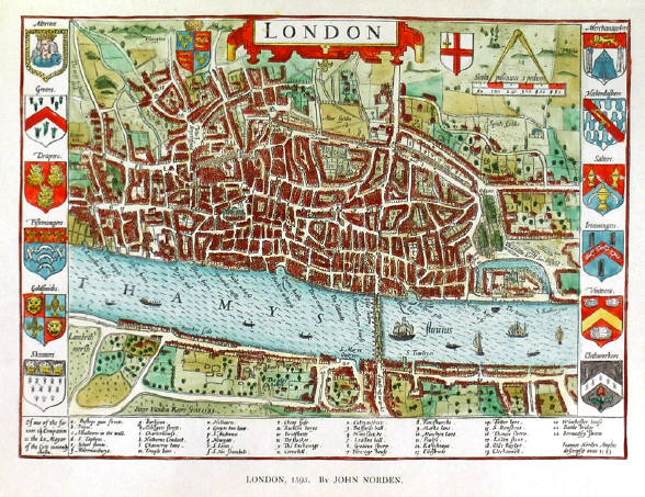 |
| 843. Braun, G. / Hogenberg, F. ĹLONDINUM FERACISSIMI ANGLIAE REGNI METROPOLISĺ. Facsimile map of Braun & Hogenbergĺs famous London map of 1572 on a much reduced scale. Published in London by A. & C. Black 1908 [26401] 14áxá21ácm. Full hand colour. Excellent condition. £60 |
 |
844. Hampton & Sons. ĹPLAN OF THE COVENT GARDEN ESTATE - FOR SALE BY HAMPTON & SONS, AUCTIONEERS & ESTATE AGENTS, 20 ST. JAMES SQUARE, LONDON. S.W.1ĺ. Estates Gazette, Kirby Street, ca. 1920 [29675] |
 |
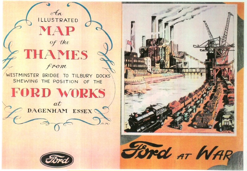
845. Ford Motor Works. ĹRIVER THAMES FROM WESTMINSTER TO TILBURYĺ. Pictorial map depicting numerous historical events and locations between Westminster and
Tilbury, including the Ford Works at Dagenham. Ford ca. 1940 [30932] 22áxá59ácm (map), 22áxá16ácm (brochure). Printed in
colours. Folding into original colour covers. Very slight wear to spine, otherwise excellent condition. £200 |
|
|