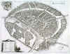
MOSCOW:1378. Merian, Matthaeus. ĎMOSCVAí. Half birds-eye view/plan of Moscow with small table of explanations from A - E and 1 - 12 and heraldic shield. North orientated to the right. Engraved by Merian and published by Johann Ludwig Gottfried in Frankfurt 1646 [20059] 27†x†35†cm. Excellent condition. £350
Uncoloured as originally published. |
 |
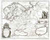
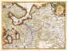
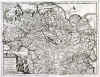
RUSSIA:1379. Merian, Matthaeus. ĎTABULA RUSSIAE ... ALIAS DICTA MOSCOVIAí. Map of Russia in Europe and the whole of Scandinavia. Large cartouche, inset view of
Archangelsk. Engraved by Merian and published by Johann Ludwig Gottfried in Frankfurt 1646 [20070] 28†x†35†cm. Excellent condition. £175
Uncoloured as originally published. |
 |
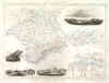
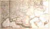
CRIMEA:1380. Tallis, J. 'THE CRIMEA'. Antique map of the Black Sea island Crimea with four vignettes and inset plan of Sebastopol
Harbour. John Tallis ca. 1851 [7851] 25†x†34†cm. Original outline
Colour. Excellent condition. £50
|
 |
MOSCOW:1381. Mallet, A. M. ĎDIE STADT MOSCAU / MOSCOVí. View of Moscow from a distance with title banner in the sky and figures in the foreground, and central inset of two Moscow squares with their churches S. Nicolas and S. Michel. Alain Manesson Mallet ca. 1719 [24171] 14†x†10†cm.
Full hand colour. Excellent condition. £150
|
 |
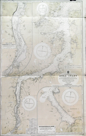
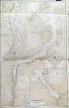
MURMANSK - RUSSIAN LAPLAND:1382. Admiralty Charts. ĎRUSSIAN LAPLAND - KOLA INLETí. Large sea chart of the Kola inlet, leading from the Barents Sea to the Russian harbour town of Murmansk (founded in 1916) and further to Kola. Two large inset charts of the Kola environs in detail and Port Alexandrovsk
(Ekateriniskaya). Published after Russian Government Charts under the Superintendence of Rear Admiral J. F. Parry at the Admiralty 1913 [26437] 106†x†66†cm. Uncoloured with overall olive tint. Excellent condition. £100
|
 |
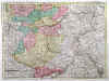
RUSSIA:1384. Sanson, N. ĎRUSSIE BLANCHE OU MOSCOVIEí. Antique map of Russia in Europe. A. díWinter for Nicolas Sanson ca. 1683 [20452] 18†x†24†cm. Original outline
colour. Excellent condition. £125
|
 |
RUSSIA:1385. Wit, F. de / Browne, Chr. ĎIMPERII RUSSICI SIVE MOSCOVIAE STATUS
GENERALIS...í. Antique map of European Russia after de Wit with figurative cartouche incorporating the Russian coat of arms supported by cherubs and scale of miles. Published by Christopher Browne in London ca. 1700 [21435] 45†x†55†cm.
Uncoloured. Excellent condition. £400
Separately published. - Christopher Browne, little known cartographer, globe maker and publisher of London. His name is is found on title pages and a few of de Witís maps. |
 |
|
RUSSIA:1386. Aa, P. v. d. ĎLA MOSCOVIE
SEPTENTRIONALE, SUIVANT LES NOUVELLES OBSERVATIONSí. Antique map of northern Russia (Europe) with pictorial cartouche. Pieter van der Aa, Leiden 1714 [25064] 23†x†30†cm.
Uncoloured. Excellent condition. £100
Folio edition - no
centrefolds. |
 |
|
RUSSIA:1387. Aa, P. v. d. ĎLA MOSCOVIE
MERIDIONALE, SUIVANT LES NOUVELLES OBSERVATIONSí. Antique map of southern Russia (Europe). Pieter van der Aa, Leiden 1714 [25065] 23†x†30†cm.
Uncoloured. Excellent condition. £100
Folio edition - no
centrefolds. |
 |
|
RUSSIA:1388. Aa, P. v. d. ĎLA MOSCOVIE
SEPTENTRIONALE, SUIVANT LES NOUVELLES OBSERVATIONSí. Antique map of northern Russia (Europe) with pictorial cartouche. Pieter van der Aa, Leiden 1714 [25619] 23†x†30†cm.
Full hand colour. Excellent condition. £120
|
 |
RUSSIA:1389A. Faden, W. / J. Nantiat. ĎTHE RUSSIAN DOMINIONS IN EUROPE drawn from the latest Maps, printed, by the Academy of Sciences, St. Petersburg; revised and corrected, withe POST ROADS & NEW GOVERNMENTS, from the Russian Atlas of 1806; by Jasper Nantiatí. Large (wall) map of Russia, printed on two double sheets, not joined. Published by William Faden 1808 [27827] 106†x†91†cm when joined. Original outline
colour. Excellent condition. £450
|

 |
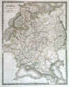
RUSSIA:1390. Hall, S. ĎRUSSIAí. Russia in Europe. Sidney Hall 1827 [19285] 51†x†41†cm. Original outline
colour. Excellent condition. £100
|
 |
RUSSIAN EMPIRE:1392. Aa, P. v. d. ĎLA GRANDE
TARTARIE, SUIVANT LES NOUVELLES OBSERVATIONSí. Antique map of the Russian Empire in Europe and Asia, reaching to Mongolia, northern China and Korea, with pictorial cartouche. Pieter van der Aa, Leiden 1714 [25135] 23†x†30†cm.
Uncoloured. Excellent condition. £120
Folio edition - no
centrefolds. |
 |
SOUTHERN RUSSIA:1397. De LíIsle, G. / Elwe, J. B. ĎPARTIE MERIDIONALE DE MOSCOVIEí. Antique map of southern Russia between Moscow and Black and Caspian Seas. Published in Amsterdam after Guillaume de LíIsle by Jan Barend Elwe ca. 1792 [24165] 41†x†55†cm. Full original
colour. Excellent condition. £200
|
 |
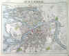
ST. PETERSBURG:1401. Letts, Son & Co. ĎCITY OF ST. PETERSBURGí. Plan of St. Petersburg. Lettsís Popular Atlas ca. 1884 [26329] 30†x†39†cm. Printed in
colours. Excellent condition. £120
|
 |
UKRAINE:1404. Letts, Son & Co. ĎRUSSIAí. Sheet No. 8 of Lettís nine sheet map of Russia, showing the Crimea and Ukraine up to almost Kiev. Lettsís Popular Atlas ca. 1884 [26833] 32†x†39†cm. Printed in
colours. Excellent condition. £100
|
 |