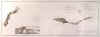
CAPE VERDE ISLANDS:1505. Janssonius, J. / Schenk, P. & Valk, G. ĹINSULAE DE CABO VERDE OLIM HESPERIDES SIVE
GORGADES...ĺ. Sea chart of the Cape Verde Islands with large decorative cartouche. Published by Pieter Schenk and Gerard Valk from the plate by Joannes Janssonius ca. 1700 [22073] 43áxá54ácm. The map in full original
colour. Excellent condition. £150
As issued, in its original state, no later colour added to cartouches etc. |
 |
|
ENGLISH CHANNEL:1507. Visscher, N. / Schenk, P. ĹMANICA, GALLIS LA
MANCHE, ET BELGIS HET CANAAL, PARS OCEANI INTER ANGLIAM ET GALLIAM...ĺ.Sea Chart of the English Channel, coastal areas and ports of southern England, Bretagne and
Normandie. Figurative cartouche and two compass roses. Published by Pieter Schenk junior from the plate by Nicolaas Visscher ca. 1720 [21844] 48áxá57ácm. The map in full original
colour. Excellent condition. £300
|
 |
ENGLISH CHANNEL:1509. Seutter, M. ĹLA PLUS GRANDE PARTIE DE LA
MANCHE...ĺ. Antique map of the eastern part of the English Channel from the Isle of Wight eastwards, including southeast England with Oxford and London, and the coastal areas of Normandy. Large pictorial cartouche. Matthaeus Seutter ca. 1730 [23557] 49áxá57ácm. The map in full original
colour. Excellent condition. £300
|
 |
NORTHERN EUROPE - GREENLAND - ICELAND:1512. Bellin, N. ĹCARTE REDUITE DES MERS DU NORDĺ. Antique map of Scandinavia, British Isles, Greenland, Labrador, and Iceland in the
centre. Defined coastlines, but without much inland detail, in the manner of a sea chart. Nicolas Bellin 1758 [21409] 33áxá45 cm. Large cartouche.
Full hand colour. Excellent condition. £150
|
 |
ENGLISH CHANNEL:1513. Lotter, T. C. ĹLA PLUS GRANDE PARTIE DE LA MANCHE QUI CONTIENT LES CÔTES DĺANGLETERRE ET CELLES DE FRANCE...ĺ. Southeast England, the Channel and parts of the French and Belgian coast. Tobias Conrad Lotter in Augsburg ca. 1770 [20108] 49áxá57ácm. Full original
colour, the large highly decorative cartouche uncoloured. Excellent condition. £300
|
 |
SUMATRA:1515. DĺAprès de Mannevillette. ĹPLAN DE LA RADE DĺACHEM ET DES ISLES CIRCONVOISINES SITUÉES A LA PARTIE DU NORD-OUEST DE SUMATRAĺ. Sea chart of the port of Banda Aceh and several adjoining islands on the north tip of Sumatra. G. Delahaye after DĺAprès de Mannevillette for Neptune Oriental ca. 1775 [19700] 48áxá33ácm. £120
|
 |
|
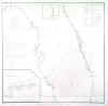
FLORIDA:1519. U.S. Coast Survey. [UNTITLED]. Coastal chart of the east and west coasts of Florida from Miami to St. Augustine and Gullivanĺs Bay to Apalachee Bay. Inset sketch of St. Johnĺs River off Jacksonville and another smaller coastal section above Jacksonville. U.S. Coast Survey 1856 [22841] 41áxá42ácm.
Uncoloured. Previously folded, but very good condition. £125
|
 |
|
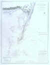
BALTIMORE:1524. U.S. Coast Survey. ĹPATAPSCO RIVER AND THE APPROACHESĺ. Large detailed chart of the mouth of the Patapsco River with soundings. Baltimore showing in the top left corner. U.S. Coast Survey 1856 [22850] 44áxá69ácm.
Uncoloured. Previously folded, but very good condition. £125
Under the direction of Superintendent A. D.
Bache. |
 |
|
MASSACHUSETTS - CAPE COD:1525. U.S. Coast Survey. Ĺ...MONOMOY SHOALS MASSACHUSETTSĺ. Large detailed chart of the Monomoy Shoals between Cape Cod and Nantucket with soundings. U.S. Coast Survey 1856 [22851] 61áxá46ácm.
Uncoloured. Previously folded, but very good condition. £125
Under the direction of Superintendent A. D.
Bache. |
 |
|
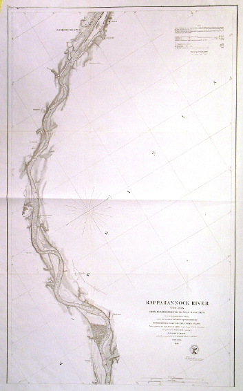
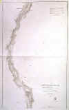
VIRGINIA - RAPPAHANNOCK RIVER:1526. U.S. Coast Survey. ĹRAPPAHANNOCK RIVER VIRGINIA FROM FREDERICKSBURG TO MOSS NECKĺ. Detailed chart with soundings of the River Rappahannock between Moss Neck and Fredericksburg. U.S. Coast Survey 1856 [22854] 73áxá45ácm.
Uncoloured. Previously folded, but very good condition. £100
Under the direction of Superintendent A. D.
Bache. |
 |
|
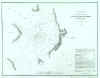
WASHINGTON TERRITORY:1528. U.S. Coast Survey. ĹOLYMPIA HARBOURĺ. Chart with soundings of Olympia
Harbour. U.S. Coast Survey 1856 [22900] 32áxá26ácm. Uncoloured. Very good condition. £80
|
 |
WASHINGTON TERRITORY:1529. U.S. Coast Survey. ĹSTEILACOOM HARBOURĺ. Chart with soundings of Steilacoom
Harbour. U.S. Coast Survey 1856 [22901] 30áxá40ácm. Uncoloured. Very good condition. £80
|
 |
CALIFORNIA:1530. U.S. Coast Survey. ĹRECONNAISSANCE OF THE S.E.END OF SAN CLEMENTE ISLANDĺ. U.S. Coast Survey 1856 [26777] 30 x 43ácm.
Uncoloured. Very good condition. £100
|
 |
CALIFORNIA:1531. U.S. Coast Survey. ĹPRELIMINARY SURVEY OF ANACAPA ISLAND AND EAST END OF SANTA CRUZ ISLANDĺ. U.S. Coast Survey 1856 [26778] 23 x 65ácm.
Uncoloured. Very good condition. £125
|
 |
HONGKONG and FORMOSA:1534. Weller, E. ĹCOAST OF CHINA FROM HAINAN
ISLD. TO HIE-CHE-CHIN BAYĺ and ĹCOAST OF CHINA FROM HIE-CHE-CHIN BAY TO SAN MOON BAYĺ. 2ácoastal maps (sea charts) on one sheet, from Hainan to Hong Kong, and from Shantou on the coast opposite Formosa to almost Ningbo south of Shanghai, showing the northern part of Formosa as well, giving soundings in fathoms. For Weekly Dispatch Atlas engraved by Edward Weller ca. 1863 [17138] 43áxá30ácm. Original one-tone
colour. Excellent condition. £90
|
 |
HAMPSHIRE - SUSSEX COAST:1535. Depot de la Marine. ĹANGLETERRE (CÔTE
SUD) DE PORTSMOUTH A BEACHY HEADĺ. Doublepage detailed seachart of the Hampshire / Sussex coast between Portsmouth / Isle of Wight, Brighton, and Eastbourne
(Beachy Head), the soundings given in metres and the position of various lighthouses indicated in yellow/red. Engraved by L. Grenier after Vialard for Depot des Cartes et Plans de la Marine 1865 [26396] 44áxá65ácm.
Uncoloured, except for surrounds and lighthouses. Small paper cut-out to top white margin (not affecting image), otherwise very good condition. £200
|
 |
ASTAKOS - DRAGAMESTI:1536. Admiralty Charts. ĹDRAGAMESTI BAY AND APPROACHESĺ. Detailed large sea chart of Dragamesti Bay on the Greek West coast, surveyed by Lieut. Morris H. Smyth. Published under the Superintendenceof Captain W. J. L. Wharton by the Admiralty 1893 [26436] 98áxá65ácm.
Uncoloured. Excellent condition. £100
|
 |
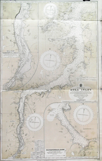
MURMANSK - RUSSIAN LAPLAND:1538. Admiralty Charts. ĹRUSSIAN LAPLAND - KOLA INLETĺ. Large sea chart of the Kola inlet, leading from the Barents Sea to the Russian harbour town of Murmansk (founded in 1916) and further to Kola. Two large inset charts of the Kola environs in detail and Port Alexandrovsk
(Ekateriniskaya). Published after Russian Government Charts under the Superintendence of Rear Admiral J. F. Parry at the Admiralty 1913 [26437] 106áxá66ácm. Uncoloured with overall olive tint. Excellent condition. £100
|
 |
PERU:1539. Admiralty Charts. ĹSOUTH AMERICA WEST COAST SHEET XII / PERU AND CHILE / CABO LOBOS TO PUNTA PESCADORESĺ. Sea chart of the south Peruvian coastline to the Chilean border at
Arica, with 3 inset harbour plans of Puerto de Ilo, Puerto Mollendo and Caleta
Ocona. First published at the Admiralty 1840, and now with a few corrections by the Admiralty 1940 [26435] 48áxá62ácm.
Uncoloured. Excellent condition. £100
|
 |
KHOR MUSA / IRAN:1540. Admiralty Charts. ĹPERSIAN GULF - KHOR MUSAĺ. Deatiled sea chart of the bay of Khor Musa on the Iran - Iraq border with three inset charts of Khor
Mashur, The Bar at Khor Musa and Bandar Shapur, from the latest information in the Hydrographic Department to 1948. Published under the Superintendence of Rear Admiral A. G. N. Wyatt by the Admiralty 1948 [26439] 99áxá66ácm. Uncoloured with overall olive tint. Excellent condition. £100
|
 |
CORSICA:1542. Admiralty Charts. ĹGULF OF ST. FLORENT (SAN
FIORENZO)ĺ. Sea chart of the Gulf of Florent on the north coast of Corsica from a French Government plan published in 1894. First published at the Admiralty 1895 under the Superintendence of Rear Admiral W. J. L. Wharton, and now with small correctionsby the Admiralty 1950 [26823] 37áxá49ácm.
Uncoloured. Folded once, otherwise excellent condition. £100
|
 |
QUEEN CHARLOTTE ISLANDS:1543. Admiralty Charts. ĹENGLEFIELD BAY AND APPROACHESĺ, ĹHOUSTON STEWART CHANNELĺ, ĹCUMSHEWA INLETĺ, and four other sea charts of other Queen Charlotte Islands (off the Canadian West coast) on one double map sheet. Compiled from earlier Canadian Government Charts under the Superintendence of Rear Admiral A. Day at the Admiralty 1952 [26434] 97áxá65ácm.
Uncoloured. Excellent condition. £120
|
 |
CHERBOURG:1544. Admiralty Charts. ĹCAPE FLAMANVILLE TO ST. MARCOUF IS.ĺ. Detailed sea chart of Cherbourg harbour on the French north coast and its environs, compiled from the latest French Government Charts to 1921. First published by the Admiralty 1888 under the Superintendence of Captain W. J. L. Wharton, and now with small corrections by the Admiralty 1953 [26438] 65áxá98ácm.
Uncoloured. Excellent condition. £100
|
 |
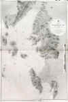
FIJI ISLANDS:1547. Admiralty Charts. ĹKANDAVU ISLAND. NGALOA BAYĺ and ĹVITI
LEVU. MBAU ROADSĺ. Two sea charts of Fiji Island bays in the South Pacific on one sheet. Published under the Superintendence of
Captn. G. H. Richards 1868 at the Admiralty 1956 [26433] 42áxá65ácm.
Uncoloured. Two small marginal tears closed, otherwise excellent condition. £120
|
 |
LISBON:1550. Admiralty Charts. ĹENTRANCE OF THE RIVER TAGUS WITH THE HARBOUR OF LISBONĺ. Large sea chart compiled from various Portuguese Government Surveys to 1879. First published by the Admiralty under the Superintendence of Rear Admiral G. H. Richards 1871, and now with latest corrections by the Admiralty 1956 [26812] 64áxá124ácm.
Uncoloured. Excellent condition. £150
|
 |
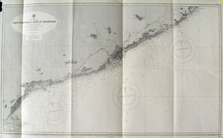
BARCELONA:1552. Admiralty Charts. ĹCAPE TORTOSA TO CAPE ST. SEBASTIANĺ. Large sea chart of the Spanish Costa Dorada and Costa Brava between the mouth of the Ebro and
Palamos, Barcelona in the centre, compiled from Spanish Government Charts to 1890. First published at the Admiralty 1892 under the Superintendence of Captain W. J. L. Wharton, and now with small corrections by the Admiralty 1956 [26825] 66áxá110ácm.
Uncoloured. Folded twice, otherwise excellent condition. £100
|
 |
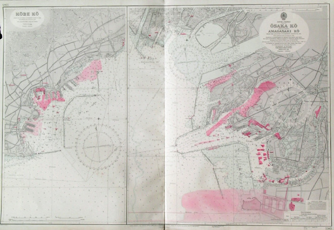
KOBE - OSAKA:1553. Admiralty Charts. ĹKOBE KOĺ and ĹOSAKA KO INCLUDING AMAGASAKI KOĺ. Two detailed sea charts of Kobe and Osaka harbours in Japan from Japanese Goernment Charts of 1939 and 1953 respectively. First published at the Admiralty 1955 under the Superintendence of Vice-Admiral Archibald Day, and now with corrections by the Admiralty 1957 [26440] 66áxá99ácm. Uncoloured with red tinted highlights. Excellent condition. £150
|
 |
BAY OF BISCAY:1554. Admiralty Charts. ĹBAY OF BISCAYĺ. Sea chart of the Bay of Biscay. First published 1953 under the Superintendence of Vice-Admiral A. Day, and now with some additions by the Admiralty 1957 [26807] 66áxá98ácm.
Uncoloured. Previously folded twice, overall soiling. £100
|
 |
ENGLISH CHANNEL:1555. Admiralty Charts. ĹENGLISH CHANNEL - WESTERN PORTIONĺ. Sea chart of the English Channel from the Isle of Wight and Cherbourg to the West, from the latest information in the Hydrographic Department to 1955 published under the Superintendence of Commodore K. St. B. Collins, and now with latest corrections by the Admiralty 1957 [26810] 66áxá99ácm.
Uncoloured. Occasional slight browning, otherwise excellent condition. £100
|
 |
GIBRALTAR - ALICANTE:1556. Admiralty Charts. ĹGIBRALTAR TO ALICANTE / CAPE SPARTEL TO CAPE FERRATĺ. Large sea chart from Spanish and French Government Charts to 1877. 15 small inset charts of Spanish
harbours. First published at the Admiralty 1878 under the Superintendence of Captain F. J. Evans, and now with latest corrections by the Admiralty 1957 [26813] 66áxá96ácm.
Uncoloured. Excellent condition. £100
|
 |
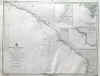
GALICIA:1558. Admiralty Charts. ĹFOZ TO CAMARIÑASĺ. Sea chart of the Galicia coast between Foz and Camariñas, with El Ferrol and La Coruna in the
centre, compiled from Spanish Government Charts of 1915 to 1920. Inset chart of Ria de Camariñas. First published at the Admiralty 1935 under the Superintendence of Rear-Admiral J. A.
Edgell, and now with small corrections by the Admiralty 1957 [26817] 66áxá99ácm.
Uncoloured. Excellent condition. £100
|
 |
BRETAGNE:1559. Admiralty Charts. ĹFRANCE NORTH COAST SHEET VIII / USHANT TO PLATEAU DES ROCHES DOUVRESĺ. Large sea chart of the French north coast between Ile dĺOuessant and Les Sept
Iles, compiled from the Pilote Français 1823 with additions and corrections to 1911. First published at the Admiralty 1902 under the Superintendence of Rear Admiral W. J. L. Wharton, and now with small corrections by the Admiralty 1957 [26818] 65áxá127ácm.
Uncoloured. Excellent condition. £100
|
 |
GALICIA - VIGO:1560. Admiralty Charts. ĹSPAIN - WEST COAST / VIGO BAYĺ. Sea chart of Vigo Bay on the Spanish West Coast, compiled from the Spanish Government Chart of 1912. First published at the Admiralty under the Superintendence of Captain J. F. Parry, and now with small corrections by the Admiralty 1957 [26820] 66áxá98ácm.
Uncoloured. Excellent condition. £100
|
 |
CAMARGUE:1561. Admiralty Charts. ĹSÈTE TO MARSEILLESĺ. Sea chart of the coast between Sète and Marseille
(Camargue) with a large inset chart of the Port of Sète, compiled from French Government Charts to 1912. First published at the Admiralty 1894 under the Superintendence of Captain W. J. L. Wharton, and now with small corrections by the Admiralty 1957 [26821] 66áxá98ácm.
Uncoloured. Excellent condition. £100
|
 |
LANGUEDOC:1562. Admiralty Charts. ĹCAPE ST. SEBASTIAN TO SÈTEĺ. Large sea chart of the coast of Languedoc in southern France and parts of the Spanish coast, compiled from the latest French and Spanish Government Charts. First published at the Admiralty 1894 under the Superintendence of Captain W. J. L. Wharton, and now with small corrections by the Admiralty 1957 [26824] 127áxá66ácm.
Uncoloured. Excellent condition. £100
|
 |
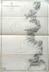
CORSICA:1563. Admiralty Charts. ĹCAPE FENO TO LAVA BAYĺ. Sea chart of the West coast of Corsica between Ajaccio and Bonifacio from French Government Surveys 1885-90. First published at the Admiralty 1895 under the Superintendence of Rear Admiral W. J. L. Wharton, and now with small corrections by the Admiralty 1957 [26827] 98áxá66ácm.
Uncoloured. Folded twice, otherwise excellent condition. £100
|
 |
CORSICA:1564. Admiralty Charts. ĹLAVA BAY TO CAPE MORSETTAĺ. Sea chart of the West coast of Corsica between Ajaccio and Calvi from French Government Surveys 1888-90. First published at the Admiralty 1895 under the Superintendence of Rear Admiral W. J. L. Wharton, and now with small corrections by the Admiralty 1957 [26828] 98áxá65ácm.
Uncoloured. Folded twice, otherwise excellent condition. £100
|
 |
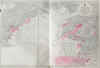
CORSICA:1565. Admiralty Charts. ĹPORTS AND ANCHORAGES IN CORSICAĺ. Sea chart of 14 ports on Corsica, from French Government Charts first published at the Admiralty 1874 under the Superintendence of Captain F. J. Evans, and now with small corrections by the Admiralty 1958 [26815] 61áxá92ácm.
Uncoloured. Folded twice, otherwise excellent condition. £180
Under the depicted ports are
Ajaccio, Bastia, Calvi, Ile Rousse, Porto Vecchio, Port Bonifacio. |
 |
|
BREST:1566. Admiralty Charts. ĹCAP DE LA CHÉVRE TO POINTE DE CORSEN INCLUDING RADE DE BRESTĺ. Sea chart of the western French coast around Brest, compiled from French Government Charts to 1921. First published at the Admiralty 1859 under the Superintendence of
Captn. Washington, and now with small corrections by the Admiralty 1958 [26819] 68áxá102 cm.
Uncoloured. Excellent condition. £100
|
 |
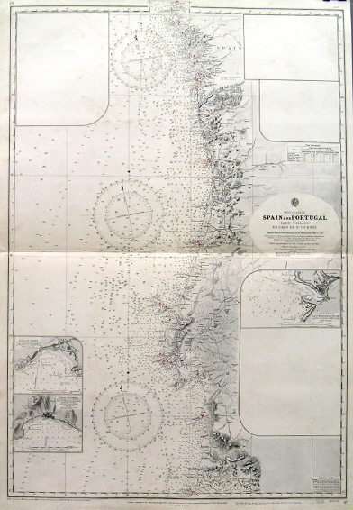
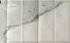
PORTUGAL:1567. Admiralty Charts. ĹSPAIN AND PORTUGAL - CABO VILLANO TO CABO DE SO. VICENTEĺ. Sea chart of the whole Portuguese coast between Cabo de S. Vicente and
Vigo/Spain. 2 inset charts of La Guardia, Baia de Sines and Baia de Sesimbra, four further inset spaces left blank. Compiled from the latest informaton in the Hydrographic Office to 1954. First published at the Admiralty 1873 under the Superintendence of Rear Admiral G. H. Richards, and now with small corrections by the Admiralty 1958 [26831] 97áxá66ácm.
Uncoloured. Excellent condition. £100
|
 |
MALTA:1571. Service Hydrographique de la Marine. ĹILES DE MALTE ET DE GOZOĺ. Large sea chart of Malta and
Gozo, first published by the Service Hydrographique de la Marine in Paris 1877 after a chart of 1863 by captains Graves and Spratt of the Birish Navy, now published with latest small corrections in Paris in 1973 [26847] 62áxá94ácm.
Uncoloured. Excellent condition. £250
|
 |