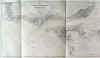
TERCEIRA / AZORES:1438. Merian, Matthaeus. ‘ANGRAE URBIS TERCERAE QUE INSULARUM QUAS AZORES
VOCANT...’. Half birds-eye view/plan of the port of Angra DO HEROISMO on Terceira in the Azores with sailing ships, two heraldic shields and title banner. Engraved by Merian and published by Johann Ludwig Gottfried in Frankfurt 1646 [20055] 21 x 33 cm. Excellent condition. £150
Uncoloured as originally published. |
 |
AZORES:1439. Montanus, A. / Ogilby, J. ‘ANGRA OP TERCERA’. View of the port of Angra on Terceira in the Azores with warships and boats in the foreground. Arias Montanus / John Ogilby 1671 [18832] 29 x 35 cm.
Uncoloured. Excellent condition. £175
|
 |
BURGOS:1440. Merian, Matthaeus. ‘BURGOS’. Panoramic view of Burgos in Spain. Engraved by Merian and published by Johann Ludwig Gottfried in Frankfurt 1646 [20054] 19 x 31 cm. Excellent condition. £150
Uncoloured as originally published. |
 |
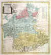
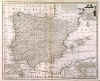
SPAIN and PORTUGAL:1441. Merian, Matthaeus. 'HISPANIA REGNUM'. Map of Spain and Portugal with heraldic shield and title cartouche. Engraved by Merian and published by Johann Ludwig Gottfried in Frankfurt 1646 [7611] 26 x 36 cm. Excellent condition. £150
Uncoloured as originally published. |
 |
LISBOA:1442. Merian, Matthaeus. ‘OLISIPPO. LISABONA’. Half birds-eye view of Lisbon with numerous sailing ships and two coats of arms in the sky and table of explanations below. Engraved by Merian and published by Johann Ludwig Gottfried in Frankfurt 1646 [20147] 28 x 36 cm. Very good condition. £250
Printer’s crease to lower right corner straightened. - Uncoloured as originally published. |
 |
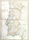
PORTUGAL:1443. Merian, Matthaeus. ‘PORTUGALLIA ET ALGARBIA QUAE OLIM LUSITANIA’. Map of Portugal, north orientated to the right. Engraved by Merian and published by M. Merian after V. A. Secco ca. 1646 [14833] 28 x 37 cm. Cartouche, coats of arms, sea monsters, sailing ships, compass roses and scale of miles. Excellent condition. £150
Uncoloured as originally published. |
 |
PORTUGAL - ALGARVE:1444. Schenk, P. ‘CORONA PORTUGALLIAE ET ALGARBIAE VETERIS HISPANIAE QOUNDAM PARS’. Map of Portugal with large uncoloured cartouche and table of explanations. Pieter Schenk 1703 [22881] 59 x 49 cm. The map in full original
colour. Very good condition. £175
|
 |
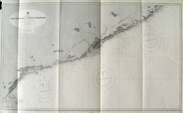
BARCELONA:1445. Admiralty Charts. ‘CAPE TORTOSA TO CAPE ST. SEBASTIAN’. Large sea chart of the Spanish Costa Dorada and Costa Brava between the mouth of the Ebro and
Palamos, Barcelona in the centre, compiled from Spanish Government Charts to 1890. First published at the Admiralty 1892 under the Superintendence of Captain W. J. L. Wharton, and now with small corrections by the Admiralty 1956 [26825] 66 x 110 cm.
Uncoloured. Folded twice, otherwise excellent condition. £100
|
 |
GALICIA:1446. Admiralty Charts. ‘FOZ TO CAMARIÑAS’. Sea chart of the Galicia coast between Foz and Camariñas, with El Ferrol and La Coruna in the
centre, compiled from Spanish Government Charts of 1915 to 1920. Inset chart of Ria de Camariñas. First published at the Admiralty 1935 under the Superintendence of Rear-Admiral J. A.
Edgell, and now with small corrections by the Admiralty 1957 [26817] 66 x 99 cm.
Uncoloured. Excellent condition. £100
|
 |
GALICIA - VIGO:1447. Admiralty Charts. ‘SPAIN - WEST COAST / VIGO BAY’. Sea chart of Vigo Bay on the Spanish West Coast, compiled from the Spanish Government Chart of 1912. First published at the Admiralty under the Superintendence of Captain J. F. Parry, and now with small corrections by the Admiralty 1957 [26820] 66 x 98 cm.
Uncoloured. Excellent condition. £100
|
 |
GIBRALTAR - ALICANTE:1450. Admiralty Charts. ‘GIBRALTAR TO ALICANTE / CAPE SPARTEL TO CAPE FERRAT’. Large sea chart from Spanish and French Government Charts to 1877. 15 small inset charts of Spanish
harbours. First published at the Admiralty 1878 under the Superintendence of Captain F. J. Evans, and now with latest corrections by the Admiralty 1957 [26813] 66 x 96 cm.
Uncoloured. Excellent condition. £100
|
 |
LISBON:1451. Admiralty Charts. ‘ENTRANCE OF THE RIVER TAGUS WITH THE HARBOUR OF LISBON’. Large sea chart compiled from various Portuguese Government Surveys to 1879. First published by the Admiralty under the Superintendence of Rear Admiral G. H. Richards 1871, and now with latest corrections by the Admiralty 1956 [26812] 64 x 124 cm.
Uncoloured. Excellent condition. £150
|
 |
MADRID - TOLEDO - LA MANCHA:1452. Homann Heirs. ‘CASTILIAE NOVAE PARS OCCIDENTALIS PROVINCIAS
MADRIT, TOLEDO ET MANCHA’. Antique map of the central Spanish povinces of Madrid, Toledo and La Mancha with pictorial cartouche and scale of miles. After designs by T. Lopez engraved by F. L. Güssefeld and published by Homann Heirs 1781 [22227] 50 x 45 cm. The map in full original
colour. Excellent condition. £150
Small insignificant brown spot, otherwise fine. |
 |
PORTUGAL:1458. Aa, P. v. d. ‘LE PORTUGAL, SUIVANT LES NOUVELLES OBSERVATIONS’. Antique map of Portugal with pictorial cartouche. Pieter van der Aa, Leiden 1714 [25122] 23 x 30 cm.
Uncoloured. Excellent condition. £120
Folio edition - no
centrefolds. |
 |
|
PORTUGAL:1459. Bowen, E. ‘A NEW AND ACCURATE MAP OF PORTUGAL...’. Antique map of Portugal. Emanuel Bowen ca. 1766 [26799] 32 x 22 cm.
Uncoloured. Excellent condition. £125
|
 |
|
PORTUGAL:1459A. Faden, W. ‘MAPPA COROGRAFICA DO REINO DE PORTUGAL / CHOROGRAPHICAL MAP OF THE KINGDOM OF PORTUGAL...’. Map of Portugal divided into its provinces. Published by William Faden 1797 [27828] 73 x 51 cm. Original outline
colour. Excellent condition. £125
|
 |
PORTUGAL:1460. Cary, J. ‘A NEW MAP OF THE KINGDOM OF PORTUGAL ...’. Antique map of Portugal. John Cary 1801 [26194] 45 x 51 cm. Full original
colour. Excellent condition. £125
|
 |
PORTUGAL:1461. Geograph. Institut Weimar. ‘CHARTE VON PORTUGAL...’. Antique map of Portugal after W. Faden’s map of 1797. Verlag des Geograph. Instituts Weimar 1817 [25822] 71 x 50 cm. Original outline
colour. Excellent condition. £150
|
 |
PORTUGAL:1462. Hall, S. ‘PORTUGAL’. Antique map of Portugal. Sidney Hall 1829 [19282] 51 x 41 cm. Original outline
colour. Excellent condition. £100
|
 |
SPAIN & PORTUGAL:1464. Aa, P. v. d. ‘L’ESPAGNE, SUIVANT LES NOUVELLES OBSERVATIONS’. Antique map of Spain and Portugal with pictorial cartouche. Pieter van der Aa, Leiden 1714 [25121] 23 x 30 cm.
Uncoloured. Very minor paper crease. £120
|
 |
SPAIN & PORTUGAL:1465. Bowen, E. ‘A NEW & ACCURATE MAP OF SPAIN AND PORTUGAL...’. Antique map of Spain and Portugal with two inset maps of the harbour of Port Mahon on Minorca and the straits of Gibraltar with the coast of Spain from Cadiz to Malaga. Pictorial cartouche. Emanuel Bowen ca. 1766 [26797] 36 x 43 cm.
Uncoloured. Excellent condition. £150
|
 |
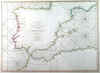
SPAIN & PORTUGAL:1466. Faden, W. / De la Rochette, Louis S. d’Arcy. ‘A CHART OF THE COASTS OF SPAIN AND PORTUGAL WITH THE BALEARIC ISLANDS...’. Sea chart of Spain and the Western Mediterranean with just the coast lines detailed. After
L.S. De la Rochette engraved and published by William Faden 1780 [27786] 51 x 70 cm. Original outline
colour. Excellent condition. £250
|
 |