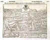
SWITZERLAND:1469. Merian, Matthaeus. ëDIE EYDTGNOSCHAFFT PÜNTEN UND WALLIS. HELVETIA CUM CONFINIISí. Map of Switzerland with large cartouche and three banners containing numerous small heraldic shields of various cantons. Engraved by Merian and published by Johann Ludwig Gottfried in Frankfurt 1646 [20063] 27†x†35†cm. Large cartouche. Excellent condition. £150
Uncoloured as originally published. |
 |
GENÈVE:1470. Merian, Matthaeus. ëGENEVE. GENFFí. Plan of Geneve in Switzerland with the fortifications. Engraved by Merian and published by Johann Ludwig Gottfried in Frankfurt 1646 [20015] 19†x†28†cm. Excellent condition. £150
Uncoloured as originally published. |
 |
BASEL:1471. Janssonius, J. 'TERRITORY BASILIENSIS NOVA
DESCRIPTIO'. Antique map of the area around Basel and southern Black Forest between
Freiburg, Waldshut, Delemont and les Vosges. Petrus Kaerius for Janssonius / Dutch Appendix 1644 [7748] 38†x†49†cm. Decorative cartouche.
Uncoloured. Very good condition. £175
|
 |
BASEL:1472. Mercator, J. / Schenk, P. & Valk, G. ëTERRITORY BASILIENSIS NOVA DESCRIPTIOí. Antique map of the area around Basel, covering the French Alsace region, the German Black Forest region, and the Swiss canton of Basel. Engraved by Peter Kaerius and now published by Pieter Schenk and Gerard Valk from the plate by Gerard Mercator ca. 1700 [22450] 38†x†48†cm. The map in full original
colour. Excellent condition. £100
|
 |
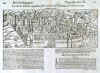
CHUR:1473. Münster, Seb. ëLA VILLE DE
CHOURES...í. View of Chur in Switzerland. Woodcut by Sebastian Münster ca. 1550 [24176] 14†x†35†cm.
Uncoloured. Excellent condition. £100
|
 |
CHUR:1474. Münster, Seb. ëDIE STATT CHUR...í. View of Chur in Switzerland. Woodcut by Sebastian Münster ca. 1550 [24177] 14†x†35†cm.
Uncoloured. Excellent condition. £80
|
 |
GENEVA:1475. Illustrated London News. ëVIEWS OF GENEVA, THE RHONE AND THE ALPS OF SAVOYí. Central view of Geneva taken from the lake. Six other views of the city above and below. Illustrated London News 1887 [26428] 32 x 46 cm.
Full hand colour. Excellent condition. £100
|
 |
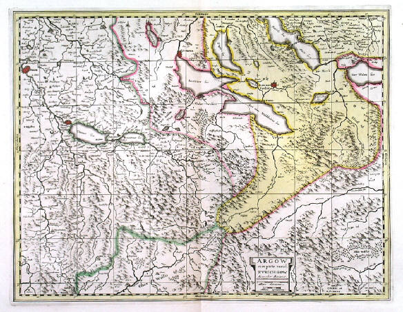
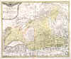
KANTON AARGAU:1476. Mercator, J. / Schenk, P. & Valk, G. ëARGOW CUM PARTE
MERID. ZURICHGOWí. Antique map of Kanton Aargau and part of Kanton Zürich in central Switzerland, reaching from Bern via Luzern to the Walensee and south to the Wallis Alps. Published by Pieter Schenk and Gerard Valk from the plate by Gerard Mercator ca. 1700 [22449] 38†x†49†cm. The map in full original
colour. Excellent condition. £100
|
 |
KANTON BASEL - ZÜRICH:1478. Janssonius, J. / Schenk, P. & Valk, G. ëZURICHGOW ET BASILIENSIS PROVINCIAí. Antique map of the area between Basel,
Schaffhausen, Luzern and Zürichsee in Switzerland with small cartouche. Published by Pieter Schenk and Gerard Valk from the plate by Joannes Janssonius ca. 1700 [22448] 38†x†49†cm. The map in full original
colour. Excellent condition. £175
|
 |
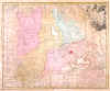
KANTON BERN:1479. Walser, G. / Homann Heirs. ëCANTON BERN SIVE ILLUSTRIS HELVETIORUM RESPUBLICA
BERNENSIS...í. Antique map of Kanton Bern and adjacent cantons in western Switzerland between Basel, Zürich, Rhone, Lac Leman / Genfer See and Lac de
Neuchatel. Large cartouche with coat of arms. After Gabriel Walser published by Homann Heirs 1766 [22451] 47†x†57†cm. The map in full original
colour. Excellent condition. £100
|
 |
KANTON GLARUS:1481. Walser, G. / Homann Heirs. ëCANTON GLARUS SIVE PAGUS HELVETIAE GLARONENSIS CUM SATRAPIA
WERDENBERG...í. Antique map of the Kanton Glarus in Switzerland between Walensee and Andermatt with cartouche, table of descriptions, vignette of a mountainous scene and inset map of
Werdenberg. After Gabriel Walser published by Homann Heirs 1768 [22455] 45†x†55†cm. The map in full original
colour. Excellent condition. £100
|
 |
KANTON LUZERN:1482. Walser, G. / Homann Heirs. ëCANTON LUCERN SIVE ILLUSTRIS HELVETIORUM RESPUBLICA LUCERNENSISí. Antique map of Kanton Luzern in Switzerland with pictorial cartouche, small table of explanations and inset map of
Giessenberg. Designed by Gabriel Walser and published by Homann Heirs 1763 [22454] 47†x†57†cm. The map in full original
colour. Slight overall browning, otherwise very good condition. £100
|
 |
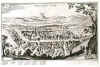
SOLOTHURN:1488. Münster, Seb. ëWARE ABCONTRAFHETUNG DER LOBLICHEN UND ALTEN STATT
SOLOTHURN...í. Half-birds-eye view/plan of Solothurn in Switzerland. Woodcut by Sebastian Münster ca. 1550 [24175] 23†x†30†cm.
Uncoloured. Excellent condition. £120
|
 |
SOLOTHURN:1489. Münster, Seb. ëLíEFFIGIE DE LA VILLE DE
SOLEURRE...í. Half-birds-eye view/plan of Solothurn in Switzerland. Woodcut by Sebastian Münster ca. 1552 [24174] 23†x†30†cm.
Uncoloured. Excellent condition. £120
|
 |
SWITZERLAND:1492. Visscher, N. ëEXACTISSIMA
HELVETIAE, RHAETIAE, VALESIAE....í. Antique map of Switzerland with title and dedication cartouche and scale of miles, all supported by cherubs. Nicolaas Visscher ca. 1685 [22445] 46†x†56†cm.
Uncoloured. Excellent condition. £100
|
 |
|
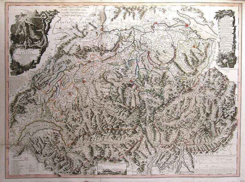
SWITZERLAND:1493. Faden, W. ëNOUVELLE CARTE DE LA SUISSE DANS LAQUELLE SONT EXACTEMENT DISTINGUES LES TREIZE CANTONS, LEURS ALLIES, ET LEURS SUJETSí. Large map of Switzerland with pictorial cartouche, table of observations, and a small vignette view of the Chamounix Valley. Printed in London for William Faden 1799 [27791] 62†x†84†cm. Original outline
colour. Excellent condition. £450
|
 |
ZÜRICH:1496. Münster, Seb. ëVON DER STATT ZÜRICH...í. View/plan of Zürich in Switzerland. Woodcut by Sebastian Münster ca. 1550 [24180] 12†x†17†cm.
Uncoloured. Excellent condition. £125
|
 |
ZURZACH:1497. Danckerts, C. ëFORUM TYBERII / ZURZACHí. Half-birds-eye view/plan of Zurzach in Switzerland. Engraved by Cornelis Danckerts after Matthias Merian ca. 1644 [24173] 19†x†32†cm.
Uncoloured. £100
|
 |