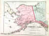
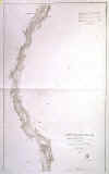
ALASKA:173. Gray, O. W. ĎMAP OF THE TERRITORY OF ALASKAí. Detailed map of Alaska. Anonymous, published by O. W. Gray in Philadelphia ca. 1881 [24587] 30†x†40†cm. Printed in full
colours. Occasional brown spotting in right margin, otherwise in very good condition. £70
|
 |
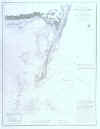
BALTIMORE:175. U.S. Coast Survey. ĎPATAPSCO RIVER AND THE APPROACHESí. Large detailed chart of the mouth of the Patapsco River with soundings. Baltimore showing in the top left corner. U.S. Coast Survey 1856 [22850] 44†x†69†cm.
Uncoloured. Previously folded, but very good condition. £125
Under the direction of Superintendent A. D.
Bache. |
 |
BOSTON:176. Sulman, T. ĎBIRDíS - EYE VIEW OF BOSTONí. A detailed view of Boston, United States, harbour and town. All the main roads and railroads into the town can be clearly seen together with Bunker Hill,Harvard University and the State House. Numerous ships are in the harbour in the foreground. A delightful piece of American history and developement in the 1870ís, engraved for the Illustrated London News after Thomas Sulman 1872 [21697] 31 x 49 cm. Full hand
colour. Excellent condition. £180
Thomas Sulman (c.1834-1900) was an English architectural
draftsman |
 |
|
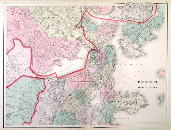
BOSTON:178. Gray, O. W. ĎBOSTON AND ADJACENT CITIESí. Detailed doublepage plan of Boston. Anonymous, but published by O. W. Gray in Philadelphia ca. 1881 [24592] 41†x†55†cm. Printed in full
colours. Excellent condition. £120
|
 |
BOSTON:180. Letts, Son & Co. ĎBOSTONí. Antique map of Boston and the harbour with list of public buildings. Lettsís Popular Atlas ca. 1884 [23757] 38†x†31†cm. Printed in
colours. Excellent condition. £100
Scale: 4 inches to the mile. |
 |
|
CALIFORNIA:182. U.S. Coast Survey. ĎRECONNAISSANCE OF THE
S. E. END OF SAN CLEMENTE ISLANDí. U.S. Coast Survey 1856 [26777] 30 x 43†cm.
Uncoloured. Very good condition. £100
|
 |
CALIFORNIA:183. U.S. Coast Survey. ĎPRELIMINARY SURVEY OF ANACAPA ISLAND AND EAST END OF SANTA CRUZ ISLANDí. U.S. Coast Survey 1856 [26778] 23 x 65†cm.
Uncoloured. Very good condition. £125
|
 |
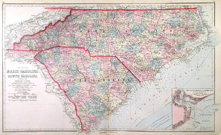
CAROLINA:185. Gray, O. W. ĎGRAYíS NEW MAP OF NORTH CAROLINA AND SOUTH CAROLINAí. Detailed doublepage map by counties with inset plan of Charleston
Harbour. Frank A. Gray for O. W. Gray in Philadelphia ca. 1881 [24601] 41†x†68†cm. Printed in full
colours. Excellent condition. £70
|
 |
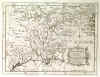
CAROLINA and GEORGIA:187. Kitchin, Th. ĎA NEW MAP OF NORTH & SOUTH CAROLINA, & GEORGIAí. Antique map of the three states between coast and Mississippi. Thomas Kitchin for London Magazine 1765 [19807] 17†x†23†cm. Cartouche, scale of miles and compass rose. Strong printing impression, excellent condition. £240
|
 |
|
EASTERN UNITED STATES:196. De Vaugondy, R. ĎNOUVELLE
ANGLETERRE, NLLE. YORK, NLLE. JERSEY, PENSILVANIE, MARILAND ET VIRGINIEí. Eastern States between New England and Carolina, incl. the Great Lakes. Robert de Vaugondy 1748 [18756] 19†x†16†cm. Original outline
colour. Excellent condition. £150
|
 |
FLORIDA:202. U.S. Coast Survey. [UNTITLED]. Coastal chart of the east and west coasts of Florida from Miami to St. Augustine and Gullivanís Bay to Apalachee Bay. Inset sketch of St. Johnís River off Jacksonville and another smaller coastal section above Jacksonville. U.S. Coast Survey 1856 [22841] 41†x†42†cm.
Uncoloured. Previously folded, but very good condition. £125
|
 |
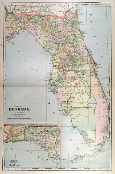
FLORIDA:205. Cram, G. F. ĎMAP OF FLORIDAí. Doublepage map with small inset map of the top northwest part of Florida. Cramís Atlas of the World 1901 [25556] 50†x†33†cm. Printed in
colours. Excellent condition. £120
|
 |
FLORIDA:206. Century Co. ĎFLORIDAí. Detailed map of Florida at the turn of the century, with inset maps of northwest Florida, Key West, and areas around Jacksonville, Tampa and St. Augustine. The Century Co. 1902 [18518] 38†x†27†cm. Printed in
colours. Excellent condition. £60
|
 |
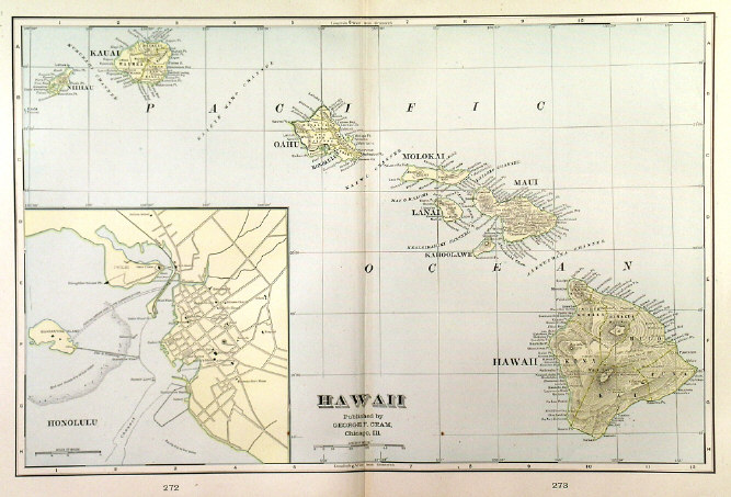
HAWAII:214. Cram, G. F. ĎHAWAIIí. Double
page map of Hawaii with large inset plan of Honolulu. Cramís Atlas of the World 1901 [25555] 29†x†44†cm. Printed in two-tone
colours. Excellent condition. £90
|
 |
LOUISIANA:216. Kitchin, Th. ĎLOUISIANA, AS FORMERLY CLAIMED BY FRANCE...í. Antique map of Southern Central States incl. all the Mississippi and Missouri area, reaching to the Colorado River in the West. Thomas Kitchin for London Magazine 1765 [19808] 18†x†23†cm. Cartouche, scale of miles and compass rose. Strong printing impression, excellent condition. £240
|
 |
MARYLAND, DELAWARE & WASHINGTON:224. Gray, O. W. ĎMARYLAND, DELAWARE AND THE DISTRICT OF COLUMBIAí. Detailed doublepage map by counties with large inset plan of WASHINGTON D.C. and 4 smaller inset plans of Wilmington, Annapolis, Annapolis Harbour and Dover. Verso two large plans of BALTIMORE (38†x†32†cm) and RICHMOND (35†x†43†cm). O. W. Gray in Philadelphia ca. 1875 [24599] 40†x†67†cm. Printed in full
colours. Excellent condition. £70
|


 |
|
MASSACHUSETTS - CAPE COD:226. U.S. Coast Survey. Ď...MONOMOY SHOALS MASSACHUSETTSí. Large detailed chart of the Monomoy Shoals between Cape Cod and Nantucket with soundings. U.S. Coast Survey 1856 [22851] 61†x†46†cm.
Uncoloured. Previously folded, but very good condition. £125
Under the direction of Superintendent A. D.
Bache. |
 |
NEBRASKA:238. Bromley, V. W. ĎDRIVING CATTLE INTO A CORRAL, NEBRASKAí. Cowboys driving cattle into a corral. Doublepage woodengraving by W. J. Palmer after V. W. Bromley 1875 [21493] 32†x†49†cm.
Full hand colour. Excellent condition. £120
|
 |
NEW YORK CITY:249. Illustrated London News. ĎOCCUPATION OF NEW YORK BY THE AMERICAN TROOPS, NOV 25TH 1783í. An historical scene in the streets of New York. Illustrated London News 1883 [23520] 35†x†48†cm.
Full hand colour. Excellent condition. 120
|
 |
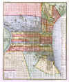
NEW YORK CITY:250. Cram, G. F. ĎNEW YORKí. Doublepage plan of Central New York (Manhattan). Cramís Atlas of the World 1901 [25551] 47†x†31†cm. Printed in
colours. Excellent condition. £75
Verso: Singlepage plans of Cincinnati and Toledo. |
 |
NEW YORK - NEW JERSEY:251. Sauthier, J. ĎMAPPA GEOGRAPHICA PROVINCIAE NOVAE EBORACI AB ANGLIS NEW-YORK
DICTAE...í. Detailed large scale map of New York and New Jersey, with parts of Connecticut, Rhode Island and Massachusetts. Printed on two sheets and joined. Large title cartouche. Claude Joseph Sauthier for Homann Heirs 1778 [18117] 72†x†56†cm. Original outline
colour, the title cartouche in later handcolour. Wide margins, excellent condition. £1200
This is a reduction of Fadenís six sheet map. Sauthier was an American surveyor and topographer. |
 |
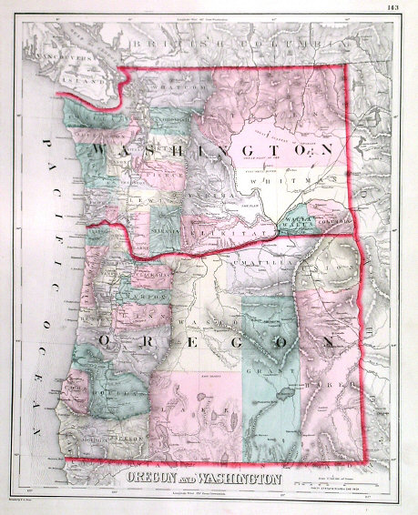
OREGON - WASHINGTON:256. Gray, O. W. ĎOREGON AND WASHINGTONí. Antique map of the States of Oregon and Washington. O. W. Gray in Philadelphia ca. 1881 [26569] 38†x†30†cm. Printed in full
colours. Excellent condition. £70
|
 |
|
PHILADELPHIA:259. S.D.U.K. 'PHILADELPHIA'. Town plan with 2 vignettes of Bank and Exchange. S.D.U.K. 1840 [7291] 37 x 42 cm. Original outline
Colour. £100
|
 |
PHILADELPHIA:260. Meyer, J. 'PHILADELPHIA'. Plan of Philadelphia. Meyer ca. 1845 [23985] 37†x†30†cm.
Full hand colour. Excellent condition. £125
|
 |
PHILADELPHIA:262. Gray, O. W. ĎPHILADELPHIAí. Detailed doublepage plan of Philadelphia. Anonymous, but published by O. W. Gray in Philadelphia ca. 1881 [24598] 42†x†62†cm. Printed in full
colours. Excellent condition. £120
|
 |
PHILADELPHIA:263. Letts, Son & Co. ĎCITY OF PHILADELPHIAí. Plan of Philadelphia. Lettsís Popular Atlas ca. 1884 [26322] 39†x†32†cm. Printed in
colours. Excellent condition. £100
|
 |
RICHMOND:263A. Ettling, T. ĎRICHMOND, VIRGINIA, THE CAPITOL OF THE CONFEDERATE STATES OF AMERICAí. A detailed town plan. London Illustrated News 1861 [28564] 17 x 24 cm. Recently coloured wood engraving. Excellent condition. £75
|
 |
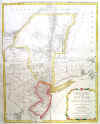
SALT LAKE CITY:264. Weller, E. ĎMAP OF THE GREAT SALT LAKE AND ADJACENT COUNTRY...í and ĎTHE GREAT SALT LAKE (MORMON) CITY AND SURROUNDING COUNTRY...í. 2†detailed maps on one sheet. Edward Weller for Weekly Dispatch Atlas ca. 1863 [17146] 43†x†31†cm overall. Original outline
colour. Excellent condition. £85
|
 |
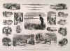
SARATOGA BOAT RACE:266. Lennox, W. ĎINCIDENTS OF PREPARATION FOR THE COLLEGE BOAT-RACES, ETC, AT SARATOGA, UNITED STATESí. Many scenes and sketches in and around the course. Sporting & Dramatic News 1875 [29797]
33 x 48 cm. Uncoloured wood engraving. £120
|
 |
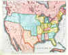
TEXAS:275. Anonymous. ĎMAP OF NORTH AMERICA, SHOWING THE RELATIVE POSITIONS OF TEXAS AND OREGON WITH THE UNITED STATESí. Map of the United States with Texas shown as an independent Republic. Published with the Illustrated London News October 11, 1845 [28584] 19 x 23 cm. Full recent hand
colour. Excellent condition. £100
|
 |
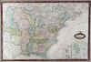
TEXAS - WESTERN TERRITORY:282. Swanston, G. H. ĎUNITED STATES NORTH AMERICA - THE SOUTH CENTRAL SECTION COMPRISING TEXAS, LOUISIANA, MISSISSIPPI, ARKANSAS, WESTERN TERRITORY AND PART OF MISSOURIí. Doublepage map, engraved by George H. Swanston and published by Archibald Fullarton ca. 1850 [25598] 51†x†40†cm. Original outline
colour. Excellent condition. £180
|
 |
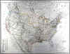
UNITED STATES:288. Garnier, F. A. ĎÉTATS-UNIS DE LíAMÉRIQUE DU
NORD. LIMITES EN 1835í. Antique map of the United States in 1835, re-published in 1860 by Jules Renouard in Paris with an amendment in the Texas area reading: ĎCe Territoire faisait partie du Mexique en 1837 et a été annexé aux États-Unis díAmérique en 1845í ( = This territory was part of Mexico in 1837 and was added to the United States in 1845). F. A. Garnier 1835 [20911] 34†x†49†cm. Cartouche. Inset maps of Florida with the Bahamas, and the islands of St. Pierre and
Miquelon. Full original colour. Excellent condition. £90
|
 |
UNITED STATES:289. Gellatly, J. ĎUNITED STATESí. States east of the Mississippi, also including Missouri, Arkansas and Louisiana. Inset map of Florida. J. Gellatly / H. Washbourne ca. 1836 [18577] 27 x†33†cm. Full original
colour. Excellent condition. £120
|
 |
|
UNITED STATES:295. Flemming, C. 'VEREINIGTE STAATEN VON
NORDAMERIKA'. Large map of the United States. Printed on four sheets, not joined. Handtke for Flemming ca. 1854 [22786] 52†x†69 cm when joined up. Original outline
colour. Excellent condition. £240
This map pre-dates the dividing of Oregon Territory into two States - Oregon and Washington. |

 |
UNITED STATES:296. Flemming, C. 'VEREINIGTE STAATEN VON
NORDAMERIKA'. Large map of the United States, joined from 4 sheets. Handtke for Flemming ca. 1855 [10546] 52†x†69 cm. Original outline
colour. This map pre-dates the dividing of Oregon Territory into two States - Oregon and Washington. £240
|
 |
UNITED STATES:298. Andriveau-Goujon, J. ĎCARTE GÉNÉRALE DES ÉTATS-UNIS ET DU MEXIQUE COMPRENANT LíAMÉRIQUE CENTRALE ET LES ANTILLESí. Large map of the United States, Mexico and West Indies, with inset maps of Central America, Lesser Antilles, New York and Long Island, and the Atlantic connections to Europe. The advancing and existing railway lines to the West are of great interest. Printed on two sheets. Eugene Andriveau-Goujon ca. 1875 [18531] 63†x†92†cm, when joined. Full original
colour. Excellent condition. £120
|
 |
|
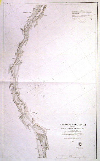
VIRGINIA - RAPPAHANNOCK RIVER:305. U.S. Coast Survey. ĎRAPPAHANNOCK RIVER VIRGINIA FROM FREDERICKSBURG TO MOSS NECKí. Detailed chart with soundings of the River Rappahannock between Moss Neck and Fredericksburg. U.S. Coast Survey 1856 [22854] 73†x†45†cm.
Uncoloured. Previously folded, but very good condition. £100
Under the direction of Superintendent A. D.
Bache. |
 |
WASHINGTON:308. Andrews, C. H. ĎBIRDSEYE VIEW OF THE CITY OF WASHINGTON WITH THE CAPITOL IN THE FOREGROUNDí. Double-page
woodengraving, showing the Capitol in its final stages of completion, by C. H. Andrews 1861 [21398] 35†x†51†cm.
Full hand colouring. Excellent condition. £280
|
 |
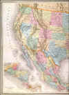
WEST COAST - CALIFORNIA:309. De Vaugondy, R. ĎCARTE DE LA CALIFORNIE ET DES PAYS NORD-OUEST SEPARÉS DE LíASIE PAR LE DÉTROIT DíANIAN...í. Detailed map of the West coast of North America as depicted in the large Visscher map of 1612, with a large inset map of western North America including
Anian, Quivira and California as shown in a large world map by Petrus Plantius of 1641. Robert de Vaugondy for Diderotís Encyclopaedia 1772 [23754] 29†x†32†cm. Recent outline
colour. Excellent condition. £350
Pedley 473. |
 |