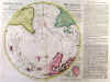
ARCTIC - ANTARCTIC:1. De L’Isle, G. / Ottens, R. & J.
‘HEMISPHERE
SEPTENTRIONAL POUR VOIR PLUS DISTINCTOMENT LES TERRES ARCTIQUES’ and
‘HEMISPHERE MERIDIONAL POUR VOIR PLUS DISTINCTOMENT LES TERRES AUSTRALES’.
Two separately published highly uncommon maps of the northern and southern
hemisphere, projected on the arctic and antarctic poles and reaching as
far as the equator. Published by Reinier & Josua Ottens from the
plates designed by
Guillaume
de L’Isle ca.
1740
.
Each
map 45 x 44 cm (image size), with further added unrecorded
printed text to the right of each map (not found anywhere else), in total
45 x 61 cm.
Full
original colour. Excellent condition.
Ł1,250
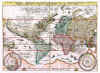
The
antarctic map shows the routes of Magellan, Tasman, Dampie
r,
Halley, etc. The additional text panel on the right side of the arctic map
gives an account of the voyage of Captain Spanberg in 1739. The maps wer
e
originally produced in 1714 and continued to be issued occasionally with
appropriate additions as late as 1770. - Highly uncommon. - The Dutch
Ottens firm of publishers assembled their atlases to order, the maps were
often published separately like this copy.
[
29857
]
|
|
ARCTIC:3. Bowen, E. ‘A CORRECT DRAUGHT OF THE NORTH POLE AND OF ALL THE COUNTRIES HITHERTO DISCOVERED...’. Antique map of the North Pole extending to northern Canada, northern Europe and northern Asia. Eman. Bowen ca. 1748 [19992] 39 x 44 cm.
Outline colour. Excellent condition. £450
|
 |
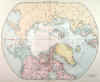
ARCTIC:4. Stanford, E. ‘MAP OF THE COUNTRIES ROUND THE NORTH POLE’. Showing the names of over 100 explorers
(Beechey, Nansen, Parry, Barents, Greely etc) and the land they discovered and points reached, including the probable drift of
Nansen, 1896. A fascinating map. Edward Stanford ca. 1896 [25243] 49 x 62 cm. Full original
colour. Excellent condition. £120
|
 |
ARCTIC:5. Stanford, E. ‘THE ARCTIC REGIONS’. Antique map of the North Pole and down to 50° latitude, showing in red the stages various explorers reached, commencing with John Cabot in 1497, Sebastian Cabot in 1498, Hudson in 1609, many others through to Duc D’Abruzzi in 1900, the probable drift of Amundsen in the ‘Fram’ 1894, Erichsen 1906-1908 and Peary in 1906. Edward Stanford ca. 1906 [25791] 49 x 61 cm. Full original
colour. Excellent condition. £120
|
 |
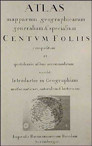
NORTHERN HEMISPHERE:13. Dorn, S. (NORTHERN HEMISPHERE ON A POLAR PROJECTION) on folio title page to Homann's 'Atlas mapparum geographicarum generalium &
specialium...'. Sebastian Dorn ca. 1730 [7262] 10 x 14 cm. North America with California as an island.
Uncoloured. Excellent condition. £100
|
 |
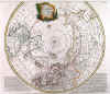
NORTHERN HEMISPHERE:14. Rhode, I. C. ‘TABULA GEOGRAPHICA HEMISPHAERII BOREALIS...’ Arctic hemisphere, showing large Bay of the West. I. C. Rhode for the Acad. Reg. Scient. et Eleg. Litt. Boruss. (Royal Prussian Academy of Sciences) ca. 1753 [17591] 31 cm diameter. Full
hand colour. Excellent condition. This map was included in Leonhard Euler’s atlas. Uncommon. £260
|
 |
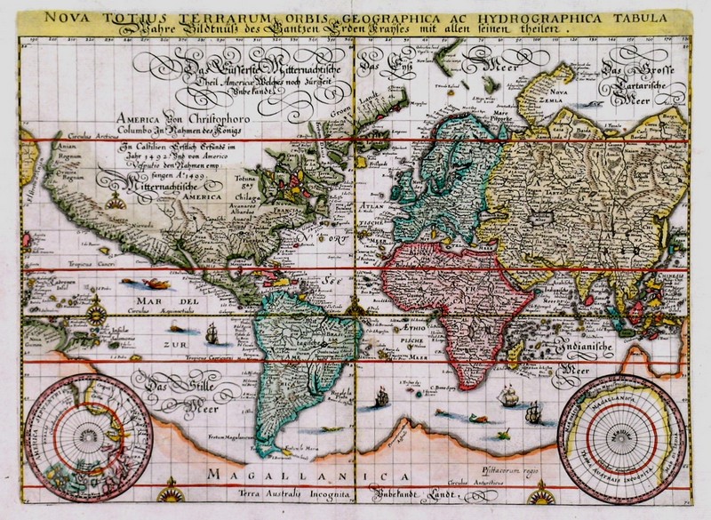
WORLD:15. Merian, Matthaeus. 'NOVA TOTIUS TERRARUM ORBIS GEOGRAPHICA AC HYDROGRAPHICA TABULA / WAHRE BILDTNÜSS DES GANTZEN ERDEN KRAYSES MIT ALLEN SEINEN
THEILEN'. Map of the world on Mercator’s projection with two small inset polar spheres. Engraved by Merian and published by Johann Ludwig Gottfried in Frankfurt 1638
[31073] 26 x 36 cm. Full recent colour. Excellent condition. £1250
Shirley 345. |
 |
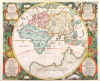
WORLD:16. Danckwerth, C. and J. Meyer. ‘ORBIS VETUS CUM ORIGINE MAGNARUM IN EO GENTIUM A FILIIS ET NEPOTIBUS NOE’. Classical representation of the Eastern Hemisphere, naming the continents of Japheth, Schem and
Cham. Border of cherubs, fruits, garlands, and garden scenes. Two cartouches in lower corners listing the descendants of Noah. Christian Rothgiesser for Caspar Danckwerth and Johann Meyer’s ‘Newe
Landesbeschreibung...’ of 1651 [19910] 43 x 53 cm. Shirley 388 (= “Scarce”).
Full recent colour. £900
|
 |
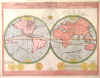
WORLD:17. Merian, M. ‘TYPUS ORBIS TERRARUM’. Double hemisphere world map, showing a large Terra Australis Incognita and California as an island. Symbols representing sun, moon and the four elements in corners and spandrels. Matthaeus Merian 1674 [23842] 17 x 25 cm. Full
hand colour. Excellent condition. £650
Uncommon. Shirley 356(A). |
 |
|
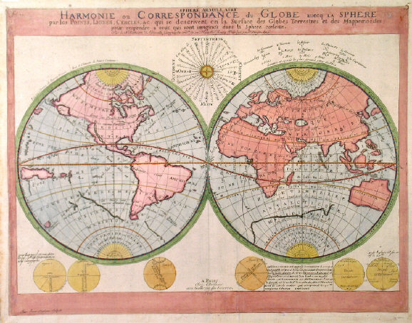
WORLD:24. Sanson, N. ‘SPHERE ARMILLAIRE - HARMONIE OU CORRESPONDANCE DU GLOBE AVECQ LA SPHERE...’. Double hemisphere world map with six small circular diagrams and
windrose, emphasizing the grid of parallels and meridians and other circles, and the climatic zones. California is shown as an island, the continents without political borders or place names. Engraved by Jean Somer Pruthenus and published by Nicolas Sanson 1705 [22814] 42 x 55 cm. Full original
colour. Excellent condition. £350
Unusual map of the world's climatic zones. As opposed to earlier versions, the Antarctic is now indicated in outline on both hemispheres, Alaska introduced, and Australia shown in a more realistic shape. |
 |
|
WORLD:36. Bellin, N. 'CARTE REDUITE DU GLOBE TERRESTRE'. World on Mercator's projection. Nicolas Bellin ca. 1764 [14515] 22 x 35 cm. Coloured copper engraving. £240
|
 |
|