WINE GRAPES:1744. Gerarde, J. ‘VITIS VINIFERA & VITIS VINIFERS HISPANICA’ etc. - Five
illustrations of vines, together with fourteen pages of text. John Gerarde 1597 [29750]
29 x 18 cm each page. Original 16th century woodcuts with original hand
colouring. Some waterstaining to white margins. £180
From Gerard’s ‘The Herball or Generall Historie of
Plantes...’, published in London 1597. Extremely detailed description of various vines and the grapes produced. |
 |
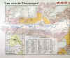
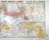
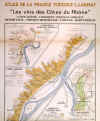
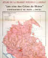
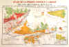
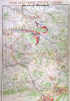
CHAMPAGNE:1800. Larmat, L. ‘LES VINS DE CHAMPAGNE - VALLÉE DE LA MARNE’. Large decorative map, showing in detail the main Champagne producing vineyards in the valley of the Marne around
Epernay. Louis Larmat ca. 1944 [24522] 37 x 92 cm. Printed in
colours, indicating the regions and quality of the wine produced. Excellent condition. £320
Vallée de la Marne is a sub-region of the Champagne wine region. It is south of Champagne and Montagne de
Reims, and north of Côte de Sézanne and Côte des Blancs. The sub-region is located on the riverbanks of the Marne. Its soils are more variable than in other Champagne sub-regions, and it contains only two Grands Crus villages: Ay and
Tours-sur-Marne. Pinot Meunier is the main grape variety. |
|
|
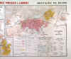
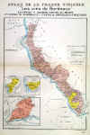
CHAMPAGNE:1801. Larmat, L. ‘LES VINS DE CHAMPAGNE - MONTAGNE DE REIMS’. Large decorative map, showing in detail the Champagne producing vineyards in the hills south of
Reims. Louis Larmat ca. 1944 [24523] 37 x 92 cm. Printed in colours, indicating the regions and quality of the wine produced. Excellent condition. £320
The Montagne de Reims lies between the Marne and the Vesle Rivers, forming a broad, undulating headland of forests and thickets that stretches east-west for about 30km and north-south for 6-10km.
The vineyards hug its western and northern flanks, planted in a huge semicircle that extends from Louvois to
Villers-Allerand. Vines carpet the limestone slopes and steep valleys of the famous Champagne villages of Bouzy and
Ambonnay, following the contours of the mountain from Trépail to
Villers-Marmery, before disappearing from view in the folds and creases of its northern flank, skirting the plain of Rheims and the famously picturesque villages of
Verzenay, Mailly and Verzy. The vineyards are predominantly planted to the Pinot Noir except in Trépail and Villers-Marmery where the Chardonnay is also cultivated. |

|
|
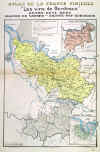
BORDEAUX:1802. Larmat, L. ‘LES VINS DE BORDEAUX - MEDOC /
HAUT-MEDOC’. Decorative map, showing in detail the famous Bordeaux vineyards to the north of Bordeaux along the
Gironde, producing Haut-Medoc, Listrac-Medoc, Moulis. Pauillac, Saint Julian,
Margaux, etc Louis Larmat ca. 1941 [24530] 56 x 37 cm. Printed in
colours. Excellent condition. £390
The Médoc district of Bordeaux is an area of coastal lagoons, sand dunes and pine forests located on the 45th parallel. It is also a global wine powerhouse, and home to four of the world's most prestigious wine villages:
Pauillac, Margaux, Saint-Estèphe and Saint-Julien. The estates located in these villages produce some of the world's most expensive bottles. |
 |
|
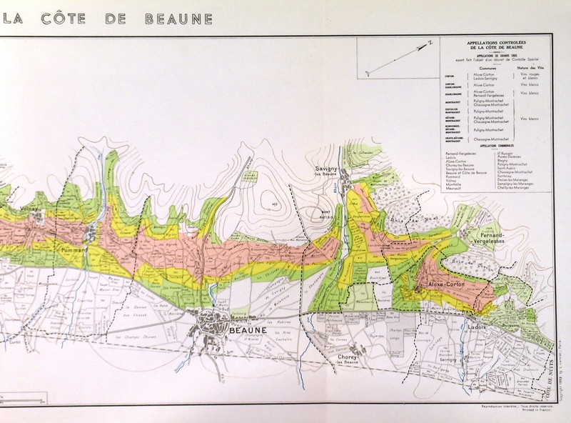
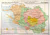
BOURGOGNE:1803. Larmat, L. ‘LES VINS DE BOURGOGNE - LA COTE DE BEAUNE’. Large decorative map, showing in detail the Côte de Beaune vineyards in the Burgundy area below Dijon around Beaune and
Puligny. Louis Larmat ca. 1942 [24535] 114 x 36 cm. Printed in
colours, indicating the regions and quality of the wine produced. Excellent condition. £890
Between Ladoix-Serrigny and the hillsides of the
Maranges, the Côte de Beaune winegrowing region covers 20km from north to south. Facing the morning sun, these vineyards are never more than a few hundred meters wide. Yet they produce red and white wines that are internationally renowned. Their reputation also extends to the town of
Beaune, an historical center where you can discover all the secrets of the Bourgogne winegrowing region. A little farther to the west, behind the Côte de
Beaune, the vines flourish on a gently concave plateau, 400m above sea level. This is the Hautes Côtes de
Beaune. On the sunniest slopes, around 20 communes produce lively and accessible wines from the Bourgogne Hautes Côtes de Beaune appellation. |


|
|
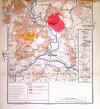
BOURGOGNE:1804. Larmat, L. ‘LES VINS DE BOURGOGNE - CHABLIS GRAND CRU’. Decorative map, showing in detail the Chablis producing vineyards near
Auxerre. Louis Larmat ca. 1942 [24536] 57 x 37 cm. Printed in colours, indicating the regions and quality of the wine produced. Excellent condition. £280
Chablis is one of the most well-known regions in France producing one of the most famous styles of Chardonnay that winemakers the world round try to imitate. The limestone clay and cool climate that is found in this area help to produce a fresh white wine packed with minerality that can age gracefully and is truly unique. |
 |
|
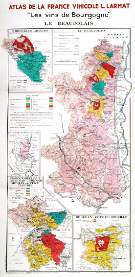
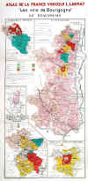
BOURGOGNE:1805. Larmat, L. ‘LES VINS DE BOURGOGNE - LE BEAUJOLAIS’. A most decorative map, showing in detail on four maps the main wine growing Burgundy wine areas. Louis Larmat ca. 1942 [24537] 56 x 37 cm. Printed in
colours, indicating the regions and quality of the wine produced. Excellent condition. £220
The wine takes its name from the historical Province of Beaujolais, a wine-producing region. It is located north of Lyon, and covers parts of the north of the Rhône département of the Rhône-Alpes region and southern areas of the Saône-et-Loire département of Burgundy. While administratively considered part of the Burgundy wine region, the climate is closer to the Rhône and the wine is sufficiently individual in character to be considered separately from Burgundy and Rhône. |
|
|
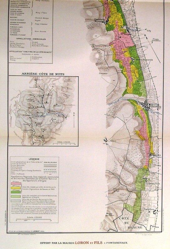
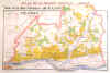
BOURGOGNE:1806. Larmat, L. ‘LES VINS DE BOURGOGNE - LA COTE DE NUITS’. Large decorative map, showing in detail the vine producing vineyards south of Dijon. Louis Larmat ca. 1942 [24539] 112 x 37 cm. Printed in
colours, indicating the regions and quality of the wine produced. Excellent condition. £890
The vines of the Côte de Nuits and Hautes Côtes de Nuits stretch over 20km from north to south. This area is the center for the region’s Grands
Crus. Mainly reputed for its red wines, it also produces a select few whites. As such, this winegrowing region is a paradise for Pinot Noir, which is used for the majority of the Bourgogne winegrowing region’s Grands
Crus. |


|
|
COTES DU RHONE:1807. Larmat, L. ‘LES VINS DES COTES DU RHONE (Septentrionale)’. Large decorative map, showing in detail the vine producing vineyards along the River Rhone from Condrieu to La
Voulte. Louis Larmat ca. 1943 [24709] 93 x 36 cm. Printed in colours, indicating the regions and quality of the wine produced. Excellent condition. £280
The Rhône wine region in Southern France is situated in the Rhône valley and produces numerous wines under various Appellation d'origine contrôlée
(AOC) designations. The region's major appellation in production volume is Côtes du Rhône
AOC. The northern sub-region produces red wines from the Syrah grape, sometimes blended with white wine grapes, and white wines from
Marsanne, Roussanne and Viognier grapes. |


|
|
COTES DU RHONE:1808. Larmat, L. ‘LES VINS DES COTES DU RHONE (Meridionale)’. Large decorative map, showing in detail the vine producing vineyards along the River Rhone from Viviers to
Avignon. Louis Larmat ca. 1943 [24710] 93 x 42 cm. Printed in colours, indicating the regions and quality of the wine produced. Excellent condition. £280
The Rhône wine region in Southern France is situated in the Rhône valley and produces numerous wines under various Appellation d'origine contrôlée
(AOC) designations. The region's major appellation in production volume is Côtes du Rhône
AOC. The southern sub-region produces an array of red, white and rosé wines, often blends of several grapes such as in Châteauneuf-du-Pape. |

|
|
COTES DU RHONE:1809. Larmat, L. ‘LES VINS DES COTES DU RHONE.
COTE-ROTIE, CONDRIEU, CHATEAU-GRILLET HERMITAGE, CROZES-HERMITAGE, CORNAS,
SAINT-PERAY’. Large decorative map, showing in detail these vine producing vineyards along the River Rhone. Louis Larmat ca. 1943 [24711] 93 x 37 cm. Printed in
colours, indicating the regions and quality of the wine produced. Excellent condition. £280
Côte Rôtie is a prestigious red-wine appellation at the northern tip of France's Rhône Valley wine region. The Syrah vines on its steep, south-east-facing slopes produce wines which are both powerful and elegant. Improvements in quality have led to increases in demand for the wines – a cycle which turned so consistently that Côte Rôtie wines are now some of France's most sought-after and most expensive.
Crozes-Hermitage is an appellation of the northern Rhone valley in France. It covers a relatively large area on the eastern bank of the Rhone river, to the north and south of Tain L'Hermitage town. Much larger than the prestigious Hermitage appellation which it surrounds,
Crozes-Hermitage is also much more prolific. In 2011 almost 70,000 hl of wine were produced and sold under the
Crozes-Hermitage title – more than the other seven northern Rhone appellations combined. |

|
|
COTES DU RHONE:1810. Larmat, L. ‘LES VINS DES COTES DU RHONE. CHATEAUNEUF DU PAPE-TAVEL’. Large decorative map, showing in detail these vine producing vineyards along the River Rhone. Louis Larmat ca. 1943 [24712] 93 x 38 cm. Printed in
colours, indicating the regions and quality of the wine produced. Excellent condition. £280
Tavel is a wine-growing Appellation d'Origine Contrôlée in the southern Rhône wine region of France, across the Rhône River from Châteauneuf-du-Pape AOC and just north of
Avignon. Tavel wines are all rosé wines and must have a minimum alcohol content of 11%. The 933 hectares produce an average yield of 42 hectolitres per hectare The vineyards are located in the commune of Tavel only. |

|
|
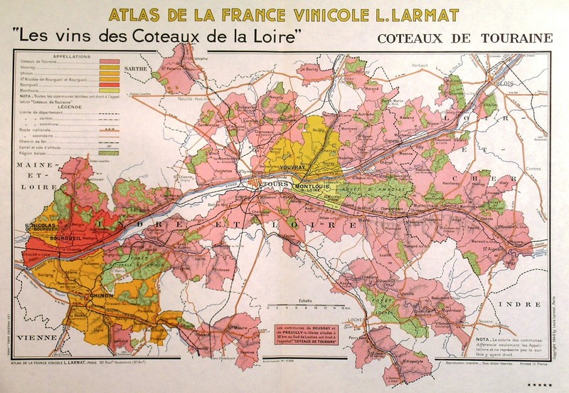
LOIRE:1811. Larmat, L. ‘LES VINS DES COTEAUX DE LA LOIRE, COTEAUX DE TOURAINE’. Decorative map, showing in detail this wine producing area along the Loire. Louis Larmat ca. 1946 [24718] 37 x 55 cm. Printed in
colours, indicating the regions and quality of the wine produced. Excellent condition. £220
Touraine is a wine district and AOC at the very heart of France's Loire Valley wine region. Its main commercial center, the city of Tours, sits precisely half-way between Sancerre and Nantes (the home of
Muscadet). Wines made under the Touraine regional appellation may be white, red, rosé or sparkling. |
 |
|
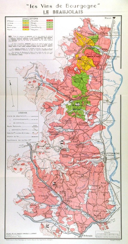
BOURGOGNE:1812. Larmat, L. ‘LES VINS DE BOURGOGNE - LE BEAUJOLAIS’. A very detailed map showing the wine areas along the River
Saone, from Macon in the North through Villefrance, down to Arbresle. Louis Larmat ca. 1952 [27026] 54 x 27 cm. Printed in
colours, indicating the regions and quality of the wine produced. Excellent condition. £280
The wine takes its name from the historical Province of Beaujolais, a wine-producing region. It is located north of Lyon, and covers parts of the north of the Rhône département of the Rhône-Alpes region and southern areas of the Saône-et-Loire département of Burgundy. While administratively considered part of the Burgundy wine region, the climate is closer to the Rhône and the wine is sufficiently individual in character to be considered separately from Burgundy and Rhône. |
 |
|
BOURGOGNE:1813. Larmat, L. ‘LES VINS DE BOURGOGNE - LA COTE DE BEAUNE’. A superb detailed map of the Cote de Beaune wine region. Louis Larmat ca. 1952 [27033] 28 x 79 cm. Printed in
colours, indicating the regions and quality of the wine produced. Excellent condition. £695
Between Ladoix-Serrigny and the hillsides of the
Maranges, the Côte de Beaune winegrowing region covers 20km from north to south. Facing the morning sun, these vineyards are never more than a few hundred meters wide. Yet they produce red and white wines that are internationally renowned. Their reputation also extends to the town of
Beaune, an historical center where you can discover all the secrets of the Bourgogne winegrowing region. A little farther to the west, behind the Côte de
Beaune, the vines flourish on a gently concave plateau, 400m above sea level. This is the Hautes Côtes de
Beaune. On the sunniest slopes, around 20 communes produce lively and accessible wines from the Bourgogne Hautes Côtes de Beaune appellation. |


|
|
BORDEAUX:1814. Larmat, L. ‘LES VINS DE BORDEAUX’. General Map of the Bordeaux wine region. Highly detailed. (Saint
Emilion, Medoc, Blayais, Cote de Blaye, Bourgeais, Graves, Sainte-Foy, Cerons, etc) Louis Larmat ca. 1946 [30343] 56 x 37 cm. Printed in
colours. Excellent condition. £420
The majority of Bordeaux wines (nearly 90 percent of production volume) are the dry, medium- and full-bodied red Bordeaux Blends that established its reputation. The finest (and most expensive) of these are the wines from the great châteaux of the
Haut-Médoc and the Right Bank appellations Saint-Émilion and
Pomerol. The former is focused (at the top level) on Cabernet Sauvignon, the latter pair on on Merlot. The official Bordeaux viticultural region stretches for 130 kilometers (80 miles) inland from the Atlantic coast. 111,000 hectares (274,000 acres) of vineyards were recorded in 2018, a figure which had remained largely consistent over the previous decade. |
 |
CHAMPAGNE:1745. Aubriet. ‘CHAMPAGNE BOTTLING, AT PIERRY, IN FRANCE’. Seven detailed images on one page, of the process of bottling Champagne. London 1855 [29835]
35 x 24 cm. Hand coloured wood engraving. £120
|
 |
|
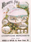
CHAMPAGNE:1746. Cornu, F. ‘MELNOTTE & FILS FOURNISSEURS DE
S.M. LA REINE D’ANGLETERRE, DE S.A. LE PRINCE DE GALLES, DE S.A.R. LE DUC D’EDINBURGH’. Melnotte &
Fils, a winery in Champagne, France. Central picture of the Establishment at
Epernay, surrounded by images of grapes, wine bottling, storage etc., designed by F. Cornu in
Epernay. Advertisement for Hedges & Butler Champagne Merchants in London, published in the Illustrated London News 1889 [29834]
35 x 24 cm. Hand coloured wood engraving. Excellent condition. £120 |
 |
BORDEAUX:1748. Larmat, L. ‘LES VINS DE BORDEAUX - LOUPIAC / SANTE-CROIX-DU-MONT / IERES COTES DE BORDEAUX’. Decorative map, showing in detail the Bordeaux producing vineyards along the
Garonne. Louis Larmat ca. 1941 [24528] 56 x 37 cm. Printed in colours. Excellent condition. £120
|
 |
BORDEAUX:1749. Larmat, L. ‘LES VINS DE BORDEAUX - GRAVES / GRAVES SUPERIEURES / CÉRONS’. Decorative map, showing in detail the Bordeaux producing vineyards to the south of Bordeaux. Louis Larmat ca. 1941 [24529] 56 x 37 cm. Printed in
colours. Excellent condition. £220
|
 |
BORDEAUX:1750. Larmat, L. ‘LES VINS DE BORDEAUX - REGION DE SAUTERNES ET BARSAC’. Decorative map, showing in detail the Bordeaux producing vineyards around Sauternes and
Barsac. Louis Larmat ca. 1941 [24531] 56 x 37 cm. Printed in colours. Excellent condition. £120
|
 |
BORDEAUX:1751. Larmat, L. ‘LES VINS DE BORDEAUX - ENTRE-DEUX-MERS / RAVES DE VAYRES / SAINTE-FOY-BORDEAUX’. Decorative map, showing in detail the Bordeaux producing vineyards between Garonne and Dordogne to the east of Bordeaux. Louis Larmat ca. 1941 [24533] 56 x 37 cm. Printed in
colours. Excellent condition. £120
|
 |
BORDEAUX:1752. Larmat, L. ‘LES VINS DE BORDEAUX - BLAYIS / COTES DE BLAYE / BOURGEAIS / COTES DE BOURG’. Decorative map, showing in detail the Bordeaux producing vineyards between Garonne and Dordogne to the northeast of Bordeaux. Louis Larmat ca. 1941 [24534] 56 x 37 cm. Printed in
colours. Excellent condition. £120
|
 |
CHAMPAGNE:1758. Larmat, L. ‘LES VINS DE CHAMPAGNE - VALLÉE DE LA MARNE ET L’AISNE’. Large decorative map, showing in detail the Champagne producing vineyards along the Marne around Chateau-Thierry. Louis Larmat ca. 1944 [24524] 37 x 88 cm. Printed in
colours, indicating the regions and quality of the wine produced. £200
|

 |
CHAMPAGNE:1759. Larmat, L. ‘LES VINS DE CHAMPAGNE - MONTAGNE DE REIMS & VALLÉE DE L’ARDRE’. Decorative map, showing in detail the Champagne producing vineyards around
Reims. Louis Larmat ca. 1944 [24525] 38 x 56 cm. Printed in colours, indicating the regions and quality of the wine produced. Excellent condition. £200
|
 |
CHAMPAGNE:1760. Larmat, L. ‘LES VINS DE CHAMPAGNE - VIGNOBLES DU
BAR-SÉQUANAIS ET DU BAR-SUR-AUBOIS’. Decorative map, showing in detail the Champagne producing vineyards in the area. Louis Larmat ca. 1944 [24526] 58 x 37 cm. Printed in
colours. Excellent condition. £150
|
 |
LOIRE:1763. Larmat, L. ‘LES VINS DES COTEAUX DE LA LOIRE’,
BOURGEIL, ST NICOLAS-DE-BOURGEIL, CHINON, MONTLOUIS, JASNIERES’. Decorative map, showing in detail these wine producing areas of the Loire. Louis Larmat ca. 1946 [24715] 37 x 55 cm. Printed in
colours, indicating the regions and quality of the wine produced. Excellent condition. £180
|
 |
LOIRE:1764. Larmat, L. ‘LES VINS DES COTEAUX DE LA LOIRE’, POUILLY SUR LOIRE, SANCERRE, QUINCY, REUILLY’. Decorative map, showing in detail these wine producing areas of the Loire. Louis Larmat ca. 1946 [24716] 37 x 55 cm. Printed in
colours, indicating the regions and quality of the wine produced. Excellent condition. £240
|
 |
LOIRE:1765. Larmat, L. ‘LES VINS DES COTEAUX DE LA LOIRE’, VOUVRAY
(Indre et Loire) Decorative map, showing in detail this wine producing area of the Loire. Louis Larmat ca. 1946 [24717] 37 x 55 cm. Printed in
colours, indicating the regions and quality of the wine produced. Excellent condition. £140
|
 |
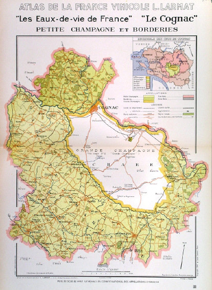
COGNAC:1767. Larmat, L. ‘LES EAUX DE VIE DE FRANCE - LE COGNAC. PETITE CHAMPAGNE ET BORDERIES’. Decorative detailed map of the area around Cognac, indicating the different areas of appellation. Louis Larmat ca. 1947 [25408] 50 x 40 cm. Printed in
colours. Excellent condition. £80
|
 |
COGNAC:1768. Larmat, L. ‘LES EAUX DE VIE DE FRANCE’ - LE COGNAC - BONS BOIS’. Louis Larmat ca. 1947 [25409] 50 x 40 cm. Printed in
colours, indicating the regions and quality of the wine produced. Excellent condition. £80
|
 |
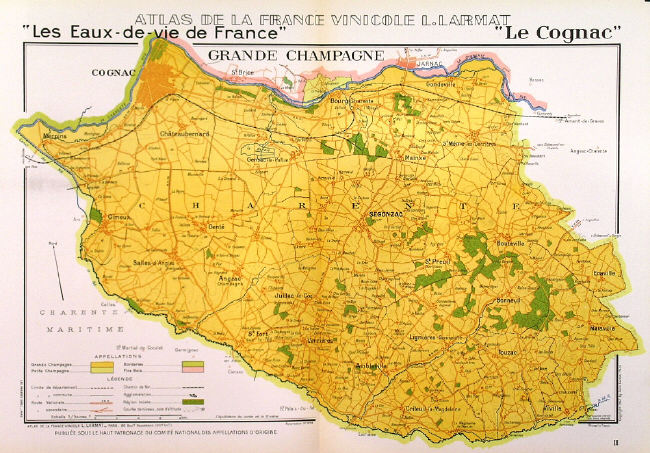
COGNAC:1769. Larmat, L. ‘LES EAUX DE VIE DE FRANCE - LE COGNAC’. Map of
Charente, the predominant region for the ‘Crus de Cognac’. Louis Larmat ca. 1947 [25410] 38 x 57 cm. Printed in
colours. Excellent condition. £100
|
 |
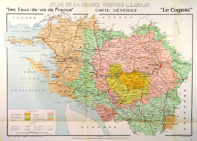
COGNAC:1770. Larmat, L. ‘LES EAUX DE VIE DE FRANCE - CARTE GENERALE - LE COGNAC’ Louis Larmat ca. 1947 [25411] 65 x 45 cm. Printed in
colours, indicating the regions and quality of the wine produced. Previously folded. Excellent condition. £180
|
 |
COGNAC - ILE DE RÉ:1771. Larmat, L. ‘LES EAUX DE VIE DE FRANCE - LE COGNAC’. Map of Charent Maritime, the French wine region around La Rochelle, reaching to Ile de Ré and Ile d’Oléron. Inset maps of Dordogne and the whole of the Cognac region. Louis Larmat ca. 1947 [25412] 36 x 55 cm. Printed in
colours. Excellent condition. £80
|
 |
COGNAC:1772. Larmat, L. ‘LES EAUX DE VIE DE FRANCE - LE COGNAC’. ‘FINS - BOIS’. Louis Larmat ca. 1947 [25413] 39 x 55 cm. Printed in
colours, indicating the regions and quality of the wine produced. Previously folded. Excellent condition. £100
|
 |
|
BORDEAUX:1774. Larmat, L. ‘LES VINS DE BORDEAUX - REGION DE SAUTERNES ET BARSAC’. Decorative map, showing in detail the Bordeaux producing vineyards around Sauternes and
Barsac. Louis Larmat ca. 1949 [24719] 40 x 27 cm. Printed in colours. Excellent condition. £120
|
 |
BORDEAUX:1775. Larmat, L. ‘LES VINS DE BORDEAUX - BLAYIS / COTES DE
BLAYE. A decorative map, showing in detail the Bordeaux producing vineyards between Garonne and Dordogne to the northeast of Bordeaux. Louis Larmat ca. 1949 [24720] 26 x 19 cm. Printed in
colours. Excellent condition. £90
|
 |
BORDEAUX:1779. Larmat, L. ‘LES VINS DE BORDEAUX - CERONS’A map of the wine area centred around Cerons and the Garonne River. Louis Larmat ca. 1949 [25400] 17 x 19 cm. Printed in
colours. Excellent condition. £90
|
 |
BORDEAUX:1780. Larmat, L. ‘LES VINS DE BORDEAUX - LOUPIAC - ST
CROIX-DU-MONT - COTES DE BORDEAUX-ST MACAIRE’. Three small maps of these wine areas along the Garonne River. Louis Larmat ca. 1949 [25401] 23 x 16 cm. Printed in
colours. Excellent condition. £90
|
 |
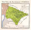
BORDEAUX:1782. Larmat, L. ‘LES VINS DE BORDEAUX - POMEROL’. Louis Larmat ca. 1949 [25403] 17 x 18 cm. Printed in
colours. Excellent condition. £90
|
 |
BORDEAUX:1783. Larmat, L. ‘LES VINS DE BORDEAUX - COTES
CANON-FRONSAC, COTES DE FRONSAC’. The wine area near to the Dordogne River. Louis Larmat ca. 1949 [25404] 17 x 19 cm. Printed in
colours. Excellent condition. £90
|
 |
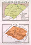
BORDEAUX:1787. Larmat, L. ‘LALANDE-DE-POMEROL’ & ‘NEAC’. Two small maps on one page. Louis Larmat ca. 1949 [26484] 11 x 15 cm each. Printed in
colours. Excellent condition. £120
|
 |
BORDEAUX:1788. Larmat, L. ‘LES VINS DE BORDEAUX - BOURGEAIS / COTES DE BOURG’. A decorative map, showing in detail the Bordeaux producing vineyards between Garonne and Dordogne to the northeast of Bordeaux. Louis Larmat ca. 1949 [27019] 25 x 19 cm. Printed in
colours. Excellent condition. £90
|
 |
BOURGOGNE:1792. Larmat, L. ‘LES VINS DE BOURGOGNE - MONTAGNY & GIVRY’. Two small maps on one page. Louis Larmat ca. 1952 [27029] 20 x 27 cm. Printed in
colours, indicating the regions and quality of the wine produced. Excellent condition. £75
|
 |
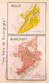
BOURGOGNE:1793. Larmat, L. ‘LES VINS DE BOURGOGNE - RULLY & MERCUREY’. Two small maps on one page. Louis Larmat ca. 1952 [27030] 28 x 17 cm. Printed in
colours, indicating the regions and quality of the wine produced. Excellent condition. £75
|
 |
CHAMPAGNE:1795. Larmat, L. ‘LES VINS DE CHAMPAGNE’. Large decorative map, showing in detail the whole Champagne producing vineyards in France. Louis Larmat ca. 1944 [24527] 92 x 58 cm. Printed in
colours. Previously folded as usual. Good condition. £450
|
 |
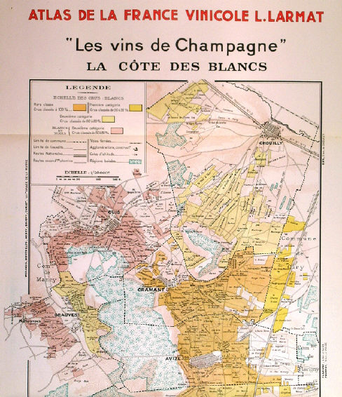
CHAMPAGNE:1796. Larmat, L. ‘LES VINS DE CHAMPAGNE - LA COTE DES BLANCS’. Large decorative map, showing in detail the main Champagne producing vineyards in the areas of
Chouilly, Cuis, Cramant, Avise, Oger, Le Mesnil -Sur Oger, & Vertus. Louis Larmat ca. 1944 [24714] 95 x 38 cm. Printed in
colours, indicating the regions and quality of the wine produced. Excellent condition. £460
|

 |
BOURGOGNE:1797. Larmat, L. ‘LES VINS DE BOURGOGNE - LE BEAUJOLAIS’. A large extremely decorative map of the whole wine region plus inset maps showing the four main areas in much detail. Louis Larmat ca. 1945 [27802] 82 x 37 cm. Printed in
colours, indicating the regions and quality of the wine produced. Excellent condition. £280
|
 |
BOURGOGNE:1798. Larmat, L. ‘LES VINS DE BOURGOGNE - LA COTE DE NUITS’. A superb detailed map of the Cote de Nuits wine region. Louis Larmat ca. 1952 [27034] 26 x 85 cm. Printed in
colours, indicating the regions and quality of the wine produced. Excellent condition. £695
|
 |
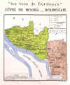
BORDEAUX:
101. Larmat, L. ‘LES VINS DE BORDEAUX -
SAINT-EMILION / POMEROL / NEAC / COTES DE FRONSAC Decorative map, showing in detail the famous Bordeaux producing vineyards around St. Emilion etc. along the Dordogne. Louis Larmat ca. 1941 [24532]
56 x 37 cm. Printed in
colours. Excellent condition. £390
Saint-Émilion is a key wine town in the Libournais district of Bordeaux, important in terms of both quality and quantity. ... Unlike the wines of the Médoc (which focus heavily on Cabernet Sauvignon), Saint-Émilion wines are predominantly made from Merlot and Cabernet Franc. |
 |
|
BORDEAUX:
102. Larmat, L. ‘LES VINS DE BORDEAUX - HAUT - MEDOC’. The wine area along the River Gironde centred around the towns of St
Estephe, Pauillac, St Julien-Beychevelle and Margaux. Louis Larmat ca. 1949 [25405]
50 x 24 cm. Printed in
colours. Excellent condition. £220
The Haut-Médoc zone is home to the "famous four" appellations of
Margaux, Pauillac, Saint-Estèphe and Saint-Julien, as well as the less famous Listrac and
Moulis. These actually account for the majority of the wines produced within the
Haut-Médoc. |
 |
|
|